- Home
- :
- All Communities
- :
- User Groups
- :
- Web AppBuilder Custom Widgets
- :
- Questions
- :
- setRenderer error getFieldsUsedInExpressions is no...
- Subscribe to RSS Feed
- Mark Topic as New
- Mark Topic as Read
- Float this Topic for Current User
- Bookmark
- Subscribe
- Mute
- Printer Friendly Page
setRenderer error getFieldsUsedInExpressions is not a function
- Mark as New
- Bookmark
- Subscribe
- Mute
- Subscribe to RSS Feed
- Permalink
Hey everyone, I am attempting to create a renderer where the user is able to select the field on which to render based off of. I need to use UniqueValueDefinition as my render which means that I cannot use RendererChooser class—Web AppBuilder for ArcGIS (Developer Edition) | ArcGIS for Developers. After selecting the field the chrome console shoots back the following error
Uncaught TypeError: a.getFieldsUsedInExpressions is not a functionMy feature layer is created like so:
var landusePolygonLayer = new FeatureLayer("https://services7.arcgis.com"),
id: "canada_Risk",//confirm works
mode: FeatureLayer.MODE_ONDEMAND,
outFields: ["*"]
});I then call getData() after the user chooses the field ( which sets currField to that field which is used in the code below.
function getData(){
classBreaks("#ffffcc", "#006837");
}
function classBreaks(c1, c2) {
var classDef = new UniqueValueDefinition();
//define ColorRamp
var colorRamp = new AlgorithmicColorRamp();
colorRamp.fromColor = new Color.fromHex(c1);
colorRamp.toColor = new Color.fromHex(c2);
colorRamp.algorithm = "hsv"; // options are: "cie-lab", "hsv", "lab-lch"
//var classField = this.get("value")
console.log("This.get(value)", currField);//confirm the field is correct in console
classDef.attributeField= currField;//set def field to the user selected field
classDef.type = "classBreaksDef";
classDef.baseSymbol = new SimpleFillSymbol("solid", null, null);
classDef.ColorRamp = colorRamp;
//var params = new GenerateRendererParameters();
//params.classificationDefinition = classDef;
console.log("here")
this.map.getLayer("canada_Risk").setRenderer(classDef);
console.log("here2")var currField
define(
['dojo/_base/declare',
"dijit/_WidgetsInTemplateMixin",
'jimu/BaseWidget',
"esri/toolbars/draw",
"esri/toolbars/edit",
"esri/graphic",
"esri/request",
"esri/config",
"esri/Color",
"esri/renderers/Renderer",
"esri/tasks/ClassBreaksDefinition",
"esri/tasks/UniqueValueDefinition",
"esri/tasks/ColorRamp",
"esri/tasks/AlgorithmicColorRamp",
"esri/tasks/GenerateRendererParameters",
"esri/tasks/GenerateRendererTask",
"esri/layers/LayerDrawingOptions",
"esri/layers/FeatureLayer",
"esri/layers/Field",
"esri/symbols/SimpleMarkerSymbol",
"esri/symbols/SimpleLineSymbol",
"esri/symbols/SimpleFillSymbol",
"esri/dijit/editing/TemplatePicker",
"esri/dijit/editing/Editor",
"dojo/_base/array",
"dojo/_base/event",
"dojo/_base/lang",
"dojo/parser",
"dijit/registry",
"dojo/data/ItemFileReadStore",
"dojox/grid/DataGrid",
"dijit/form/FilteringSelect",
"dijit/form/Select",
"dojo/on",
"dojo/data/ObjectStore",
"dojo/store/Memory",
"dojo/domReady!"],
function(declare,_WidgetsInTemplateMixin, BaseWidget, Draw, Edit, Graphic, esriRequest, esriConfig, Color,Renderer,
ClassBreaksDefinition, UniqueValueDefinition, ColorRamp, AlgorithmicColorRamp,
GenerateRendererParameters, GenerateRendererTask, LayerDrawingOptions,
FeatureLayer,Field,
SimpleMarkerSymbol, SimpleLineSymbol, SimpleFillSymbol,
TemplatePicker,Editor,
arrayUtils, event, lang, parser, registry, ItemFileReadStore, DataGrid, FilteringSelect,Select, On,ObjectStore, Memory) {Solved! Go to Solution.
- Mark as New
- Bookmark
- Subscribe
- Mute
- Subscribe to RSS Feed
- Permalink
Abhinav,
So like I said I tested this and it worked fine for me using my service url. So the next question is are you using the right symbol type? The code is setup to symbolize a Polygon feature.
- Mark as New
- Bookmark
- Subscribe
- Mute
- Subscribe to RSS Feed
- Permalink
This is great! Maybe a new thread, but the layer is not refreshing with the new symbology until I navigate or zoom.
I'm attempting to put a legend in too, but that is off topic.
- Mark as New
- Bookmark
- Subscribe
- Mute
- Subscribe to RSS Feed
- Permalink
David,
It that version I forgot to add a layer refresh (line 4):
generateRenderer.execute(params, lang.hitch(this, function(renderer){
console.info(renderer);
this.map.getLayer("canada_Risk").setRenderer(renderer);
this.map.getLayer("canada_Risk").refresh();
}), lang.hitch(this, function(err){
console.info(err);
}));- Mark as New
- Bookmark
- Subscribe
- Mute
- Subscribe to RSS Feed
- Permalink
Yeah i have a regular feature layer (not a dynamic layer or anything) that is a polygon feature. with full control over the polygon.
- Mark as New
- Bookmark
- Subscribe
- Mute
- Subscribe to RSS Feed
- Permalink
Is your layer publicly accessible? If so can you share the url for me to test?
- Mark as New
- Bookmark
- Subscribe
- Mute
- Subscribe to RSS Feed
- Permalink
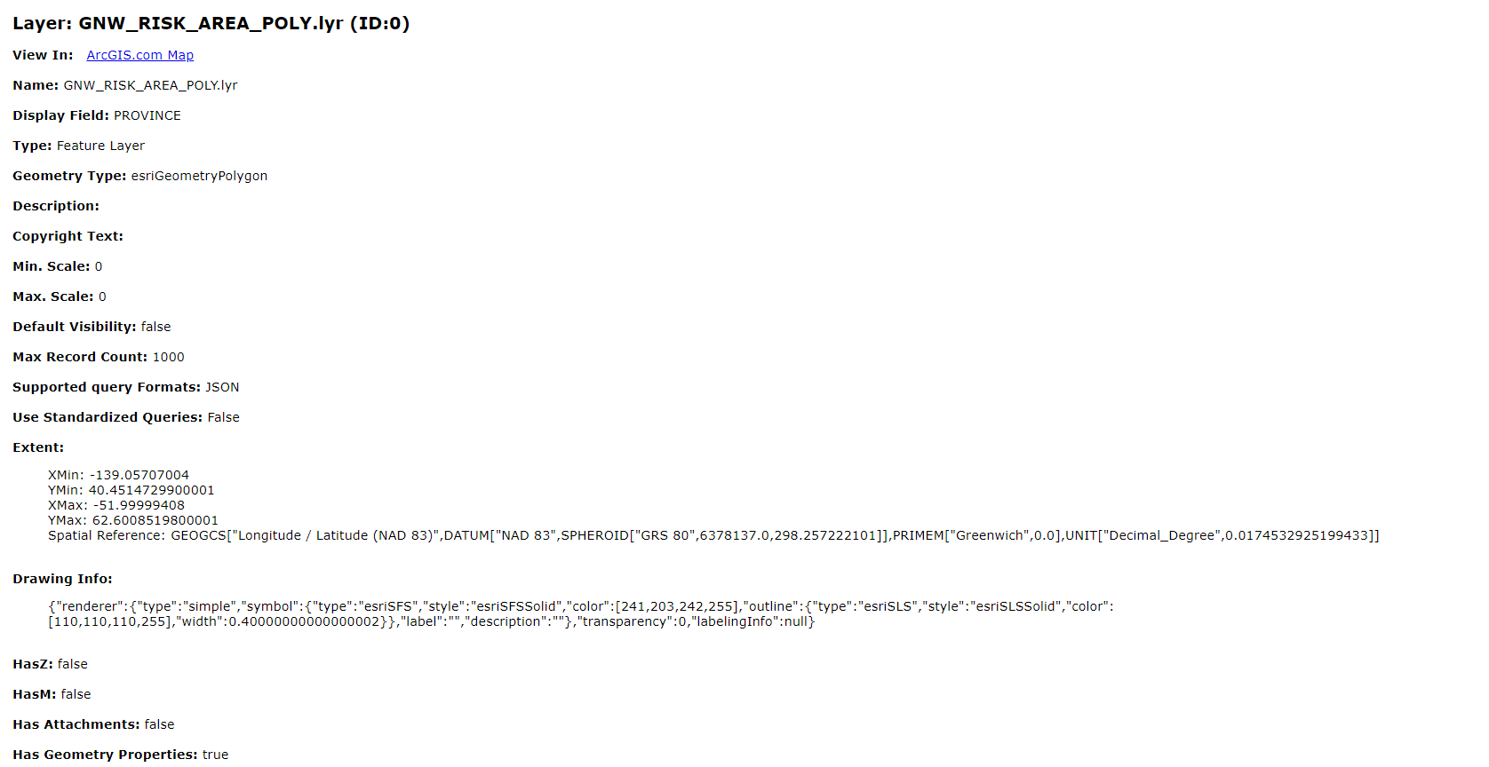
Im sorry Robert, it isn't publiv and I am unable to make it public. only thing I can think of that could be different is the fact that it has been optimized for layer drawing in the layer settings. But I do not believe that could cause an issue.
The layer does have a lot of polygons as well. I do not know if the screenshot below will help.
- Mark as New
- Bookmark
- Subscribe
- Mute
- Subscribe to RSS Feed
- Permalink
Not sure what to tell you then. I have provided code that I have tested on my end to work with data I use.
- Mark as New
- Bookmark
- Subscribe
- Mute
- Subscribe to RSS Feed
- Permalink
Yea, you have done everything you can and ill mark the zip file comment as correct. If I am able to fix my issue I will post an update in this thread.
Thanks for all the help Robert!
- Mark as New
- Bookmark
- Subscribe
- Mute
- Subscribe to RSS Feed
- Permalink
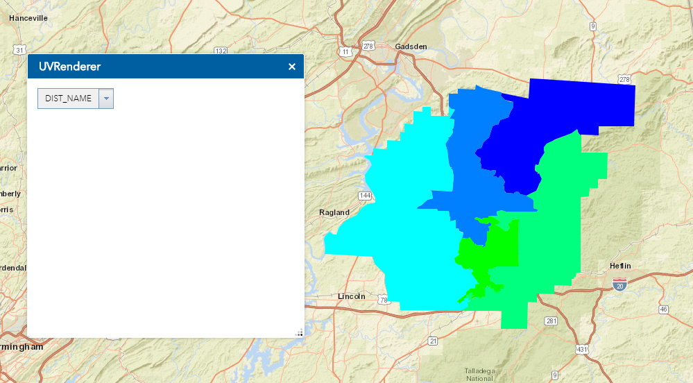
I think what is happening that the renderer is not attaching the symbols to the values (hopefully I worded that correctly)
here is an example of the legend after setting the renderer.
those are the correct values for the field i have chosen but they are given a null symbol. I don't see why it would do that for my feature layer but not for your feature layer.
- Mark as New
- Bookmark
- Subscribe
- Mute
- Subscribe to RSS Feed
- Permalink
I too downloaded @RobertScheitlin__GISP 's attached widget code and my results are similar to yours. The values for the field are shown but the symbols are not.
- « Previous
-
- 1
- 2
- Next »
- « Previous
-
- 1
- 2
- Next »