- Home
- :
- All Communities
- :
- User Groups
- :
- Web AppBuilder Custom Widgets
- :
- Questions
- :
- Re: eDraw widget
- Subscribe to RSS Feed
- Mark Topic as New
- Mark Topic as Read
- Float this Topic for Current User
- Bookmark
- Subscribe
- Mute
- Printer Friendly Page
- Mark as New
- Bookmark
- Subscribe
- Mute
- Subscribe to RSS Feed
- Permalink
Ehanced draw widget for WebApp Builder for Arcgis
UPDATE 2018/05/09 (new Release v2.8.1) :
- refactoring
- use esri/geometry/projection (available since esri js api 3.24) instead of proj4js (external libs)
- systematic use of geometry engine (no more mercator utils, geometry server...)
- for polyline, the user can now add an arrow (available since esri js api 3.23)
- live measure while drawing
- WARNING : this release needs Esri API >= 3.24
(Direct zip link : https://github.com/magis-nc/esri-webappbuilder-widget-eDraw/releases/download/v2.8.1/eDraw.zip )
Demo : https://apps.magis.nc/demo/eDraw/
Github :
https://github.com/magis-nc/esri-webappbuilder-widget-eDraw
Wigdet's Features (improvments of standard Draw widget) :
- add name and description fields on drawings
- enable infowindow on drawings (selection)
- on text drawing, no insert if no name.
- on modification : enable geometry update (with snapping if wanted : CTRL) and preview symbology changes on the fly
- list
- add list of all drawings
- actions on each drawing : modify / delete / [up / down] / zoom
- all drawings : zoom, copy, delete, export
- on drawing infowindow -> select drawing in list
- on zoom on a drawing -> select drawing on map (and show infoWindow)
- re-order graphics with drag&drop
- import/export : allow users to export or import drawings (json format)
- import can be done with file drag&drop in import popup
- localStorage
- dynamic saving on each drawing add/delete/update
- on widget load : load drawings saved in local Storage
- draws plus (initially from Larry Stout https://geonet.esri.com/people/Larry_Stout)
- preview under mouse when adding text or point
- for text, add font choice, font angle, bold, italic, placement and underline options.
- add arrow menu for polyline
- checkbox to hide drawing's layer (and therefore widget UI)
- add of Nautical unit
- measure's for points/polylines/polygons with automatic update on element's update (or delete). Measure's can be indidualy disabled/enabled on any graphic.
- "On the fly" measure when drawing
- defaults symbols can be specified in config's file
- use of builtin projection engine (available since esri js api 3.24) instead of proj4js library
This message was updated by Jeremie Cornet (New Release)
GIS enthousiast, python & javascript lover
Solved! Go to Solution.
- Mark as New
- Bookmark
- Subscribe
- Mute
- Subscribe to RSS Feed
- Permalink
Thanks Jeremie. This may not be exactly the goal of the widget as well, but when a user has several drawings in the drawings list, it would be nice for the user to export an individual drawing within the drawing list, not the entire list.
- Mark as New
- Bookmark
- Subscribe
- Mute
- Subscribe to RSS Feed
- Permalink
Zachary Schmitt Good idea. I will add it in a future release.
GIS enthousiast, python & javascript lover
- Mark as New
- Bookmark
- Subscribe
- Mute
- Subscribe to RSS Feed
- Permalink
Hi, Thanks for this widget. I wanted to ask if it is possible to publish the json file to ArcGIS online account as a GeoJSON?
- Mark as New
- Bookmark
- Subscribe
- Mute
- Subscribe to RSS Feed
- Permalink
Hello,
great widget! Works fine in WAB Dev Edition 1.1. I upgraded to WAB DEV Edition 1.2 but it seems that it will need a few tweaks to make it work in the latest edition?
"create widget error:
widgets/eDraw/Widget"
Have you experienced any issues with the latest edition yourself?
Thanks, Monika
- Mark as New
- Bookmark
- Subscribe
- Mute
- Subscribe to RSS Feed
- Permalink
Hello Monika,
Could you describe your context (browser(s), wab theme...) and, if possible, paste the whole error ?
I have some style's issues with new themes but the widget works for me.
GIS enthousiast, python & javascript lover
- Mark as New
- Bookmark
- Subscribe
- Mute
- Subscribe to RSS Feed
- Permalink
Hi Jeremie,
I'm using Firefox 38.0.5. I have tried IE10 as well (10.0.9200.17413). I tried every single theme which is available in WAB 1.2 - error message below:
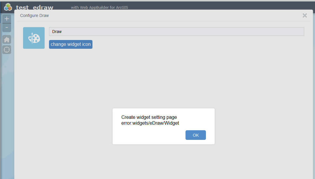
Thanks, Monika
- Mark as New
- Bookmark
- Subscribe
- Mute
- Subscribe to RSS Feed
- Permalink
Thanks,
I havn't understood it was in the builder and in the widget configuration.
In deployed apps, the widget still works well with wab dev 1.2.
I can reproduce the error so i will dig it.
GIS enthousiast, python & javascript lover
- Mark as New
- Bookmark
- Subscribe
- Mute
- Subscribe to RSS Feed
- Permalink
New release for WAB 1.2
Monika Honkova Issue corrected
GIS enthousiast, python & javascript lover
- Mark as New
- Bookmark
- Subscribe
- Mute
- Subscribe to RSS Feed
- Permalink
@Jeremie Cornet - is it possible to have the measurements update as the shapes are modified? Or is there a way to create a new measurement based on shape modifications?
- Mark as New
- Bookmark
- Subscribe
- Mute
- Subscribe to RSS Feed
- Permalink
Adam Gebhart It's not possible now.
You're not the only one who wants that functionnality 
I will add it in a future release but it's a big change in widget's architecture.
GIS enthousiast, python & javascript lover