- Home
- :
- All Communities
- :
- User Groups
- :
- Web AppBuilder Custom Widgets
- :
- Questions
- :
- Re: Edit Graphics Drawn with Draw Widget
- Subscribe to RSS Feed
- Mark Topic as New
- Mark Topic as Read
- Float this Topic for Current User
- Bookmark
- Subscribe
- Mute
- Printer Friendly Page
- Mark as New
- Bookmark
- Subscribe
- Mute
- Subscribe to RSS Feed
- Permalink
anyone have this done already?
I modified the Draw Widget, so that is it completely custom, and I have made it add the output to table of contents (Feature Layer),
anyways, my question is, does anyone know how to make the graphics editable? (I am aware of a context menu, but just wondering if anyone has done it yet, I have seen it in the eDraw widget, but not the Draw widget)?
Thanks,
Solved! Go to Solution.
Accepted Solutions
- Mark as New
- Bookmark
- Subscribe
- Mute
- Subscribe to RSS Feed
- Permalink
Hey All,
I solved it, I basically figured out an alternative to updating the operational layers
this was solved by creating an edit button and save button in the widget
- operational layer can't be edited therefore
- built edit button that calls function that removes operation layer, and clears graphics layer
- left over with a graphic, that user can now edit (editing graphics is stupid easy)
- when user hits save, it syncs the newly edited graphic to the operational layers of the map
- Mark as New
- Bookmark
- Subscribe
- Mute
- Subscribe to RSS Feed
- Permalink
Douglas,
The eDraw is based off of the otb draw widget so should be able to borrow code from it.
- Mark as New
- Bookmark
- Subscribe
- Mute
- Subscribe to RSS Feed
- Permalink
yup, I borrowed the code from it, but its doing something rather funny, perhaps you might know what it is,
I am able to edit the graphic (only able to edit vertices, the move, rotate, and scale options do not work),
I am using something along these lines (same as eDraw widget)
editorActivateGeometryEdit : function (graphic) {
if (!graphic)
this.editorActivateSnapping(false);
if (!graphic && this._editorConfig["editToolbar"]) {
this._editorConfig["editToolbar"].deactivate();
return;
}
var tool = 0 | Edit.MOVE;
if (graphic.geometry.type != "point")
tool = tool | Edit.EDIT_VERTICES | Edit.SCALE | Edit.ROTATE;
var options = {
allowAddVertices : true,
allowDeleteVertices : true,
uniformScaling : true
};
this._editorConfig["editToolbar"].activate(tool, graphic, options);
},
but I am not able to actually rotate, move or scale, only move vertices,
probably something stupidly simple.
thanks for the help, let me know
- Mark as New
- Bookmark
- Subscribe
- Mute
- Subscribe to RSS Feed
- Permalink
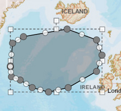
Douglas,
So you are not getting the extent box around the geometry with handles for re-sizing and rotating? Like in this image?
- Mark as New
- Bookmark
- Subscribe
- Mute
- Subscribe to RSS Feed
- Permalink
Exactly,I have been testing different things and I have only been able to edit vertices
- Mark as New
- Bookmark
- Subscribe
- Mute
- Subscribe to RSS Feed
- Permalink
Douglas,
do you mean something like this ArcGIS Web Application just right click the graphic you have created.
You can get the code here Enhanced Draw Widget
Tim
- Mark as New
- Bookmark
- Subscribe
- Mute
- Subscribe to RSS Feed
- Permalink
Hey Tim,
looks like your right, I originally had taken the code from the Draw Widget, and enhanced draw widget,
I am still somewhat puzzled why I can only use the Edit.MOVE_VERTICES handle in my code, but the move, rotate, and scale wont work,
perhaps its because you have the OnOpen method and you set
var map = this.map;
editToolbar = new Edit(map);
where I have my editToolbar initialization in the PostCreate Method.
I will keep posted with any updates, but I am assuming this will solve my issue based on the code.
- Mark as New
- Bookmark
- Subscribe
- Mute
- Subscribe to RSS Feed
- Permalink
or
have any if you guys had luck with enabling the edit toolbar for operational layers?? (created via draw widget)? I have modified AdvDraw widget and Draw Widget, but still no luck for editing operational layers (created from graphics), editing graphics are no issue, just operational layers
- Mark as New
- Bookmark
- Subscribe
- Mute
- Subscribe to RSS Feed
- Permalink
Douglas,
No I personally have not but I will do some testing when time permits and report back.
- Mark as New
- Bookmark
- Subscribe
- Mute
- Subscribe to RSS Feed
- Permalink
Hey All,
I solved it, I basically figured out an alternative to updating the operational layers
this was solved by creating an edit button and save button in the widget
- operational layer can't be edited therefore
- built edit button that calls function that removes operation layer, and clears graphics layer
- left over with a graphic, that user can now edit (editing graphics is stupid easy)
- when user hits save, it syncs the newly edited graphic to the operational layers of the map