- Home
- :
- All Communities
- :
- User Groups
- :
- Web AppBuilder Custom Widgets
- :
- Documents
- :
- Identify Widget Version 2.21 - 11/16/2021
- Subscribe to RSS Feed
- Mark as New
- Mark as Read
- Bookmark
- Subscribe
- Printer Friendly Page
Identify Widget Version 2.21 - 11/16/2021
Identify Widget Version 2.21 - 11/16/2021
Web AppBuilder for ArcGIS | Help - Identify Widget
List of the latest enhancements and changes:
- Added 10 max rows max display to widgets dropdowns.
- Fixed a mixed protocol issue in code
Previous enhancements and changes:
Check the "Older enhancements or changes.txt" in the download for a complete list.
Older Versions
ATTENTION:
- If you are hosting this widget on a https server, then make sure you change all your excludelayer urls to https. Failure to do so will result in widget failure.
Features:
- Specify which layers are to be identified
- Format the fields for identify layers
- Configure links and link icon
- Close result popups after a number of seconds of losing focus
- Choose which layer to identify in the widget UI using drop down list
- Specify layers to be excluded from identify operation
- Choose to only identify configured layers
- Replace null values with empty strings
- Configure default symbology for identify results
- Specify Visible, Top, or All layers to be identified.
- Option to Keep Identify Active
- All Identify geometry types are configurable
- Option to use map time
Raviteja,
I would have to say no currently to the identify result going to the attribute table. I just don't want to go there.
And also is there any configuration that helps to enforce Layers Visibility to the Identify layers.
Can you explain in detail what you are talking about here? Currently the widget only identifies the visible (either toggled on or scale dependent) layers if you have the widget configured that way.
Sure Robert here is the expectation
For example I have set a visibility range for Traffic Cameras to 1:1 to 1:30,000 , users should be able to identify only during this visibility range , I don't want user to be able to identify the Traffic Cameras at a scale 1:30,000 to Infinity where this layer will not be visible,
I love this widget Robert!
One thing that would be nice would be the ability to change the order of the results when you have "All Layers" in the Identify from in the widget.
The issue i have is if i have 5 layers turned on and i do an Identify it displays the results in a set random order, i would like to be able to set the most important layer results first, I currently have to scroll down a ways to look at the layer that has the highest importance. I see that i can select the layer from the "Identify from" but it would only show me just one layer.
Thanks.
Raviteja,
So you are saying that you have tested this and it is not working for you?.. I have not seen any issue with layer scale visible dependency.
Hi,
Thank you for your widget
I found a small problem,
If the configuration links to the layers begin with http:
"layers": { "layer": [ {"url": "http://...........
And the application is started on the link httpS://
Widget does not work
issues where there is a check
if(url.toUpperCase() === this.configIdentLayers.url.toUpperCase()){
url.toUpperCase() begin with https
but this.configIdentLayers.url.toUpperCase() begin with http
Andrew,
I can not say that, that makes any sense. The line of code you are referencing is in the isService2beIdentified function and if the layers url is https then you should have https in your configuration for that layer as well. I don't use https so I have not tested https though.
I did not want to duplicate the configuration separately for http and https
I'm a little rewrite your script added the function
isUrlsEqual it tests url's without sheme, and replaced all the places where there is a link checking
I Don't know how to attach the script here
Andrew,
Attaching code is not available in a documents comments on GeoNet. I am interested in what you did so if you would please start a new discussion where you can attach the code I would be grateful.
I put on dropbox
Thanks Andrew.
Robert
Does this widget work with relates created within published ArcMap map services, or relationship classes?
Nathan,
No relates are not supported at this time.
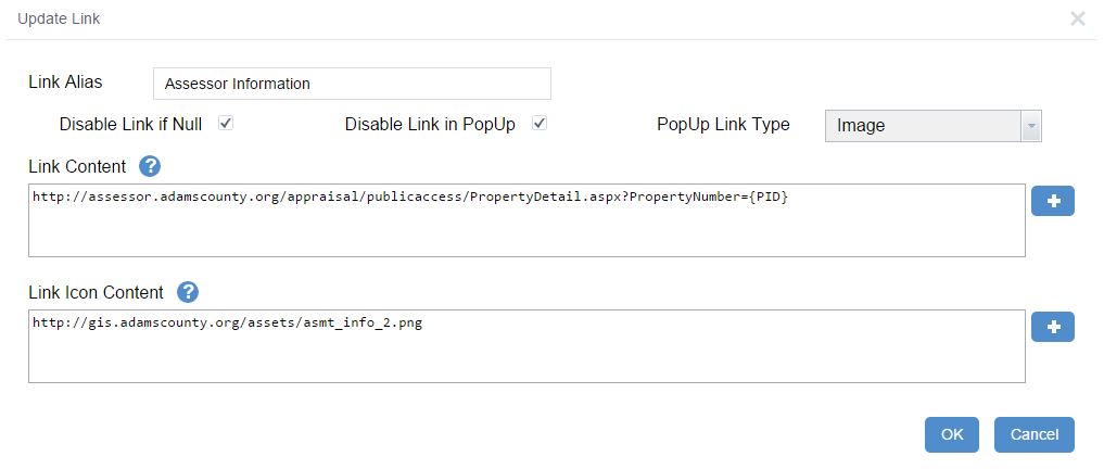
Robert,
I have your identify widget installed in my WAB. I am working with the links. I want icons to be my links in the results window, however I do not want the links to show up in my popup window. I have Disable Link PopUp selected. However, when the Link Type is set to Image it does not disable. If it is set to text, it disables but in the results window my links are Text. Am I able to have an link icon in the results window but not in the popup. Attached is what my current settings are. Also, I am trying to do the same thing in the Search widget and getting the same results.
Lindsey,
Looks like I currently ignore the disable link property if the link is an image. Something I will have to address in the next release.
Robert,
Thanks for the great work with the widgets, it's much appreciated. However, we've come across a bug with the Identify widget. In the Layer List widget, when you have a Parent layer turned on and a Child layer turned off, any sublayers of the Child layer that are turned on despite the Child layer being turned off will still appear in the results of the Identify widget.
I've attached some screengrabs of the Local Layer widget to clarify the Parent-Child-Sublayer relationship (in this case, Utilities-Water-BBoxes), and an Identify result when using a point selection on a Parcel layer which returns a BBox and Water Main feature despite the Water layer being turned off. I would assume the sublayers should be excluded from the results since the child layer is turned off.
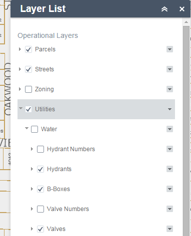
Currently we can work around this by turning off the parent layer, but this may be something to consider changing for future revisions to the Identify widget. If there's a toggle in the widget configuration that I'm missing regarding this, let me know.
Thanks.
This perhaps relates to the way in which the ESRI Layer List TOC does not seem to function correctly.
A TOC should behave like AGS JS TOC, i.e. where child layers sync with parent status. In other words, behaving hierarchically. It does not, currently. Unchecking a parent layer doesn't uncheck child layers. The 3.14 beta TOC widget has the issue as well.
John,
Thanks for the info I will look into this.
John,
What version of the LocalLayer widget are you using? I am not seeing this behavior.
Robert,
We are using version 1.5.1 of the Local Layer Widget.
I also tried it on the big 3 browsers (Chrome, Firefox, IE) and got the same issue on each.
John,
Hmm... maybe it has something to do with ArcGIS Server version then. What version of AGS are you on?
AGS 10.3, the service layers are dynamic. Here's the copypasta from the Water service description:
Layer: Water (ID: 0)
Sub Layers: [deleted]
Name: Water
Display Field:
Type: Group Layer
Geometry Type: null
Description:
Definition Expression: N/A
Copyright Text:
Default Visibility: false
MaxRecordCount: 0
Supported Query Formats: JSON, AMF
Min Scale: 0
Max Scale: 0
Supports Advanced Queries: false
Supports Statistics: false
Has Labels: false
Can Modify Layer: false
Can Scale Symbols: false
Use Standardized Queries: true
Extent:
- XMin: 1073885.7969295867
- YMin: 2062198.5672310963
- XMax: 1105551.4681781717
- YMax: 2090002.2645763457
- Spatial Reference: 102671 (3435)
Drawing Info:
- N/A
Advanced Query Capabilities:
- Supports Statistics: false
- Supports OrderBy: false
- Supports Distinct: false
- Supports Pagination: false
- Supports TrueCurve: true
HasZ: false
HasM: false
Has Attachments: false
HTML Popup Type: esriServerHTMLPopupTypeNone
Type ID Field: null
Fields: None
Supported Operations:
I had to delete the sublayer list to prevent automatic linking
Do you anticipate any changes to the Identify widget to conform to the WAB 1.2 release? Just curious as you said you have to make changes to the Enhanced Search widget.
Adam,
Yes there will be some needed code changes.
Hi Robert,
Many thanks for the new widget version for WD 1.2. 
If you Alt+click on widget header, you get this popup:
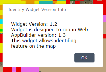
Shouldn't it say that the widget is designed for WAB 1.2, not 1.3? Also, there are some spelling errors..."This widget allows identifying features on the map."
Cheers,
Barnaby
Barnaby,
Actually no. The Real WAB version number is 1.3 even though it is called 1.2. It has always been one version number ahead of what it is called.
Ok, thanks for the info. That versioning is a little confusing for users, but once we know the deal, it's ok.
Robert,
I'm trying to use an identify on many of my map services that are dynamic, but it seems that the results are only showing the feature services, not any of the dynamic ones. Any idea on what might be causing this?
I've even tried placing the urls to the services in the identify layers configuration option and it still isn't working.
ID widget 1.2 is working properly on dynamic services for me (tiled and untiled)....
(using a WAB 1.2 app that is using an AGOL Web Map, not LocalLayer widget)
Daniel,
I have to echo what Barnaby says. I am not seeing any issue with identifying dynamic layers.
I'm trying to work with the services that I've added using the local layer widget, not ones that were on the webmap. Could this be the issue?
In another WAB 1.2 app using the LL widget 1.6 (broken in WAB 1.2  ), the current version of ID widget is still working perfectly....
I started a new web application using 1.2 and added the layer to LL widget 1.6 and it still isn't identifying the service.
However, when adding a feature service, it works only on the feature service.
Same is true if I add in the feature level of a dynamic service. It just doesn't work if I have it as a dynamic service.
Robert,
Can you think of a reason why the ID widget wouldn't work properly when a WAB app is hosted on a forced-https domain server? I have no problems when an app is hosted on http domains...
Cheers,
Barnaby
Barnay,
No I can not but I don't have access to https to test. Is your Server with https public?
Yes, but I don't want to post the links here. Can I PM you with the links?
-Barnaby
sure
I think you have to "follow" me before I can PM you. Let me know if there is another way I can shoot you the links.
done
PM sent. 
Hi Robert,
I have a very large service of point data loaded in a WAB viewer. If I use the ID widget rectangle select tool to select some points, they are highlighted (default in light blue color). If I then click on the ID results of one of those points in the ID widget display, it is impossible to see which of the points I just clicked on. The screen does center on the point I have highlighted.
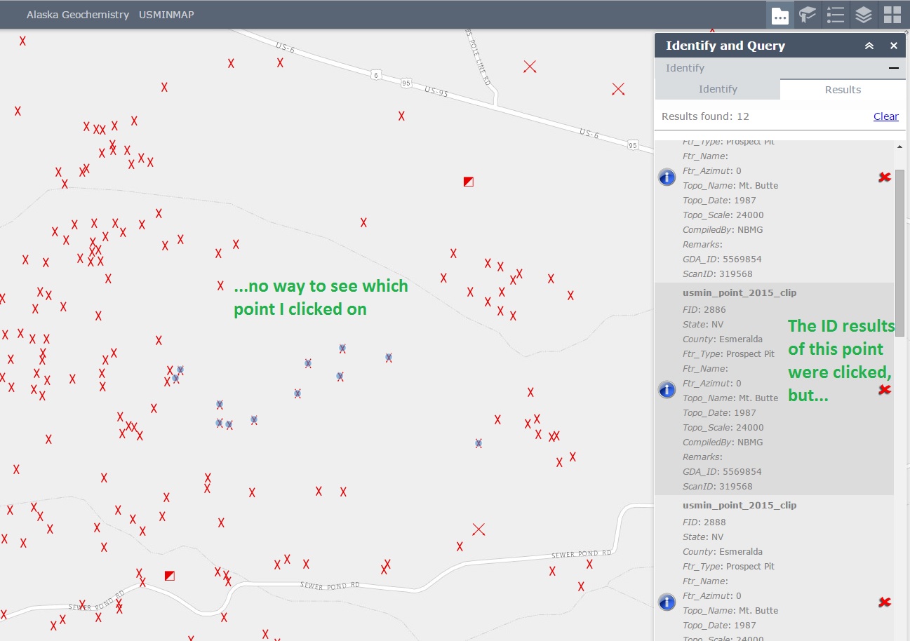
In Flex ID widget, the single point I have clicked on in the ID widget window gets a nice halo around it, showing which point I have highlighted:
Is there a way to configure the WAB ID widget so that I would get a halo or some such indicator when I click on a ID result? If not, is there a way you could enhance the WAB ID widget to get such an indicator?
Cheers,
Barnaby
Barnaby,
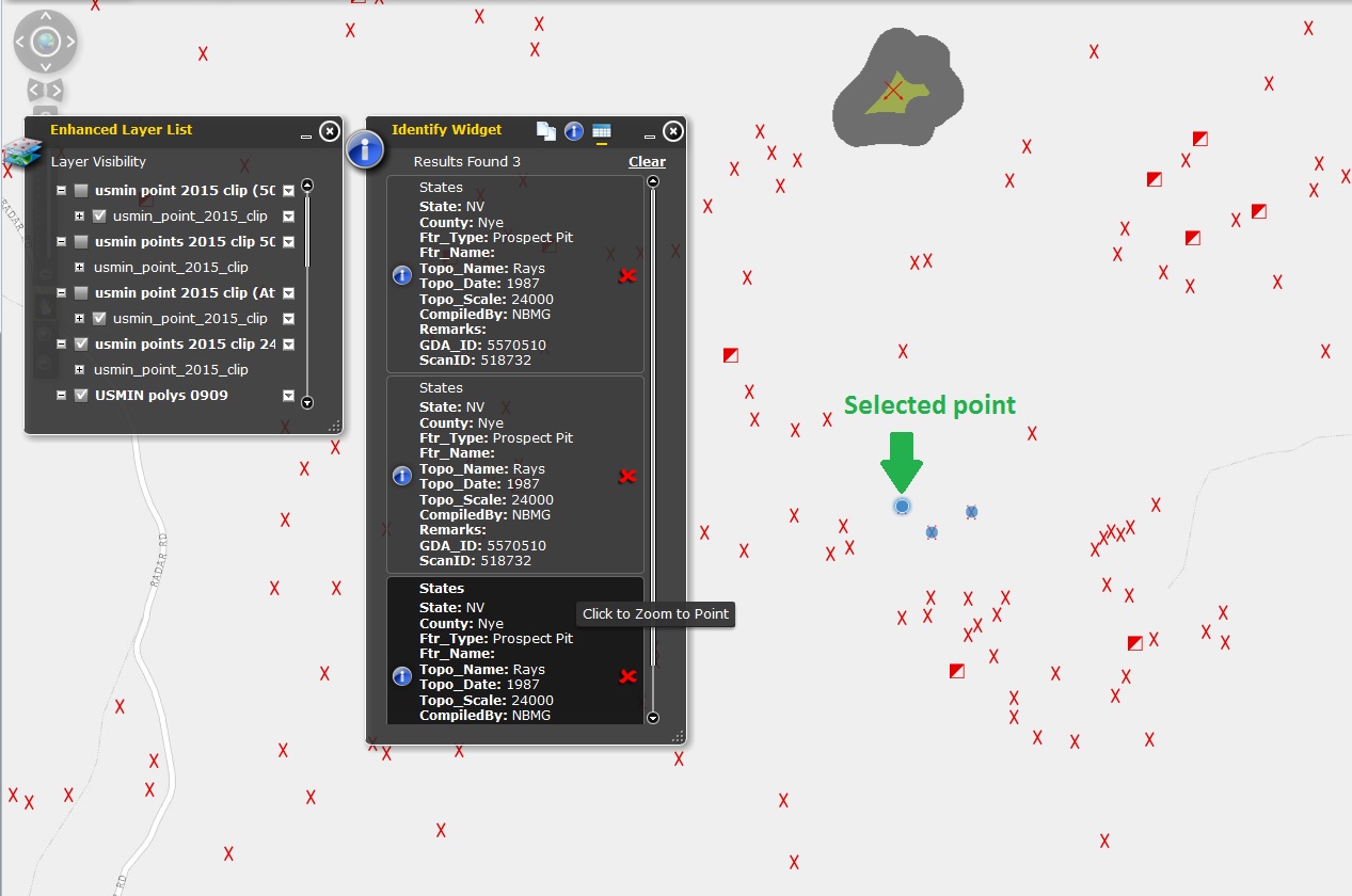
Sounds like you need to "Enable Mouse Over Result Info Windows" this highlights the feature and displays the info window.
Identify selection only returns all layers. I have my Parcel layer setup as an identify layer, however it doesn't return any results when selected individual. I do get results when I select "all layers", the parcel layer then returns with all the other layers. any tips?
Robert Scheitlin Leo Ladefian I'm also seeing this exact same thing, with the Identify widget from June for WAB 1.1. I will be posting a live site with a publicly accessible layer hopefully today or tomorrow for reference. All Layers works, specific ones like Address Points don't. Also it appears Identify 'unclicks' the selector, such as Point or Circle, for Identify area. Anyone else seeing these?
I am not clear on this
Also it appears Identify 'unclicks' the selector, such as Point or Circle, for Identify area. Anyone else seeing these?
Leo,
I can not duplicate this using my live preview site. I can choose any specific layer and that layer does return results.
Thanks for the reply, it does appear to function correctly on your live site. It just appears with my own app. Wondering if you had experienced this issue before and had a fix for it. It seems to be layer specifc so I've been tinkering with the publishing settings to no avail:
http://services5.arcgis.com/xfq44TYLhoTF2Raq/arcgis/rest/services/Parcels/FeatureServer/0
Hi Robert,
Yes, that will do the trick for my app. Thanks!
But I still like the subtle halo around selected points in Flex.
Cheers,
Barnaby
Branaby,
Yep the JS API does things differently for highlighting points
Leo,
I don't have any problem adding your layer to my map and identifying it as the selected layer in the drop down. Maybe you should start a discussion question so that you can post your config_Identify.json (you can not attach things in a documents comments section, which this is).
Here is a really interesting bug for you. (Using the newest versions of both eSearch and Identify.) When you complete an eSearch with the option to 'add results as an operational layer' and then attempt to use identify the identify app hangs indefinitely.
This is not unique to eSearch. This is true for any app that adds data as an operational layer (i.e. query).