- Home
- :
- All Communities
- :
- Industries
- :
- Water Resources
- :
- Water Resources Questions
- :
- Re: Trace downstream - returning errors today
- Subscribe to RSS Feed
- Mark Topic as New
- Mark Topic as Read
- Float this Topic for Current User
- Bookmark
- Subscribe
- Mute
- Printer Friendly Page
Trace downstream - returning errors today
- Mark as New
- Bookmark
- Subscribe
- Mute
- Subscribe to RSS Feed
- Permalink
- Report Inappropriate Content
I've found this to be a great tool and better than the standard toolbox downstream trace. Today, I'm getting errors I've never seen before from this tool. Any advice on what can be done to fix these server messages would be great. Any hint appreciated, thanks.
- Mark as New
- Bookmark
- Subscribe
- Mute
- Subscribe to RSS Feed
- Permalink
- Report Inappropriate Content
what are your inputs? since nothing is returned, is there an error there? check those in Results
- Mark as New
- Bookmark
- Subscribe
- Mute
- Subscribe to RSS Feed
- Permalink
- Report Inappropriate Content
Hello, I'm running the tool from the right hand tray in arcmap under ready to use services, and the input is a FC of points in arcmap, which is how I've run the tool before. There is no error in the input in geoprocessing results, just in the server messages, unfortunately.
- Mark as New
- Bookmark
- Subscribe
- Mute
- Subscribe to RSS Feed
- Permalink
- Report Inappropriate Content
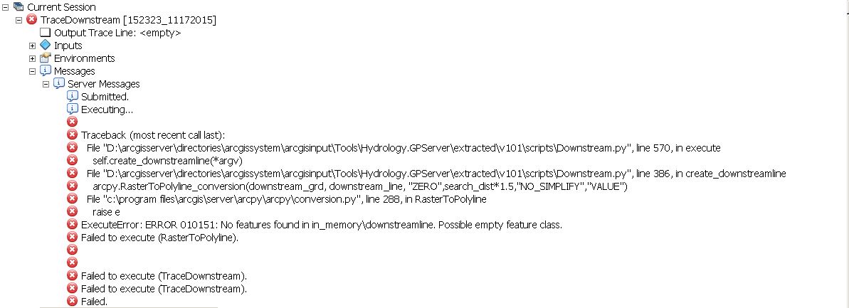
I'm referring to this hosted geoprocessing service - Trace Downstream—ArcGIS REST API: Elevation Analysis services | ArcGIS for Developers
used in ArcMap. I have normally accessed this via citrix arcmap, from the arccatalog drawer, ready to use services, and was getting the error messages in the first screenshot. We had some network issues on our end yesterday, so maybe that was it, but the same data with and without the optional parameters all worked correctly today. -?-
- Mark as New
- Bookmark
- Subscribe
- Mute
- Subscribe to RSS Feed
- Permalink
- Report Inappropriate Content
strange? no clue then...
- Mark as New
- Bookmark
- Subscribe
- Mute
- Subscribe to RSS Feed
- Permalink
- Report Inappropriate Content
It'd be easier if you just capture the screen and post to us so we know what you are talking about.