- Home
- :
- All Communities
- :
- Industries
- :
- Water Resources
- :
- Water Resources Questions
- :
- Stream Order (Strahler) and Flow Direction
- Subscribe to RSS Feed
- Mark Topic as New
- Mark Topic as Read
- Float this Topic for Current User
- Bookmark
- Subscribe
- Mute
- Printer Friendly Page
Stream Order (Strahler) and Flow Direction
- Mark as New
- Bookmark
- Subscribe
- Mute
- Subscribe to RSS Feed
- Permalink
The problem that I have is that I need to ensure that the flow direction of the existing river centerlines that I wish to use is correct and secondly need to assign a stream order (Strahler) to the river centerline segments.
I've attached a screen shot of the river centerlines to help explain the problem that I have with the currently available river centerline dataset. There are numerous segments that should be tributaries but do not extended enough to link up with the main river. I'm looking for advice in how I can make use of the available river centerlines to embed into my terrain. Do I eliminate the segments that are not connected to the main river centerlines.
What is the most efficient methodology to rectify the river centerlines to a point that they won't add additional error to my terrain dataset, which I then would like to use to generate a river centerline network to build up an hydro data model. Any assistance will be appreciated.
- Mark as New
- Bookmark
- Subscribe
- Mute
- Subscribe to RSS Feed
- Permalink
Is this what you meant by parallel streams? I did use a small buffer as you suggested, but I could make it wider. Within the stream order tool, I used a raster version of the stream polyline and the flow direction output.
Is there an easier way to perform this analysis within ArcHydro?
- Mark as New
- Bookmark
- Subscribe
- Mute
- Subscribe to RSS Feed
- Permalink
I am having the same issue when I use my own streams which have braids and loops. If I let ArcHydro define the streams for me then it works just fine. The jpg that you attached doesn't show any braided streams, but I am wondering if your data did contain braids. I think the Stream Order cannot handle braided networks. Can anyone confirm this?
- Mark as New
- Bookmark
- Subscribe
- Mute
- Subscribe to RSS Feed
- Permalink
StreamOrder uses flow direction as input, i.e. flow can only go one way so braided network are not supported.
If you have a braided network you can use the Assign River Order tool from the Arc Hydro toolbox or Arc Hydro Python toolbox. It is located in the Attribute tool toolset. This tool takes as optional input a flow split table that allows the tool to handle braids.
Coming in with your own streams feature class you will need to run the following tools:
· Assign HydroID
· Generate From/To Node for Lines (store connectivity)
· Find NextDownstream Line (to create the flow split table and NextDownIDs)
· Assign River Order.
Also the field OmitUp (0/1) if present is used to reset the order to 1 in a secondary braid segment.
Christine Dartiguenave
Esri Water Resources Team
- Mark as New
- Bookmark
- Subscribe
- Mute
- Subscribe to RSS Feed
- Permalink
Great! That works for the most part. I am using HND streams and am having trouble with all of the streams being assigned a river order. I am attaching a gdb with a sample. Here is also a clip of the message that I receive saying that 44 of the segments did not receive a stream order. If you could direct me to a solution I would greatly appreciate it.
- Mark as New
- Bookmark
- Subscribe
- Mute
- Subscribe to RSS Feed
- Permalink
Your problem is that you have a loop in your streams. The tool cannot figure out loops.
Look at your features with HydroID 1603 and 1699. You need to flip one of the segments, then rerun Generate From Node/To Node, Find Next Downstream Line and Assign River Order.
Chirstine
- Mark as New
- Bookmark
- Subscribe
- Mute
- Subscribe to RSS Feed
- Permalink
Great! Thanks for the help.
- Mark as New
- Bookmark
- Subscribe
- Mute
- Subscribe to RSS Feed
- Permalink
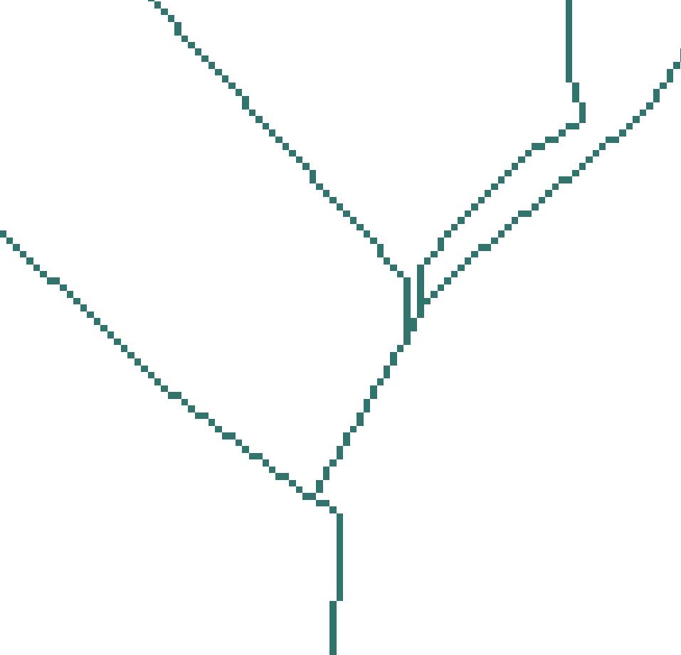
In my image, if you look at the confluence to the right of the center of the image, you will see parallel streams defined for a short distance (mine is a 10'x10' grid). They are only one cell apart. If I were to redo this one, I would add agreestream features to burn the DEM so the parallel streams merge (that is if I knew they should not be parallel and should come together sooner).
- Mark as New
- Bookmark
- Subscribe
- Mute
- Subscribe to RSS Feed
- Permalink
My workflow:
1) Polyline to Raster conversion (1 on a background of NoData)
2) Burn the polylines into the DEM.
2) Fill the burned DEM
3) Flow Direction
4) Use the stream raster and flow direction outputs in the Stream Order tool.
Could this problem be due to a high resolution DEM? Since I am using a buffer (-100) around the stream lines, I'd think that the flow path/direction would not be a problem.
- Mark as New
- Bookmark
- Subscribe
- Mute
- Subscribe to RSS Feed
- Permalink
For your stream raster, you may need a value of greater than 1 to make the burn work. Use the Con() function to create another stream raster where 1 is changed to -1000, then add the two rasters. This will definitely burn the streams deep.
- Mark as New
- Bookmark
- Subscribe
- Mute
- Subscribe to RSS Feed
- Permalink
When I burned the stream into the DEM, I made sure the stream value was -1000 with a buffer of -100. I used the stream raster of value 1 as the input into the stream order tool.
I think the stream raster sometimes looks like there are 2 cells because the polyline curves or runs along the edge of the raster cell. I'm not sure how to get around that.