- Home
- :
- All Communities
- :
- Industries
- :
- Water Resources
- :
- Water Resources Questions
- :
- how can I solve ERROR 010151 using Hec-GeoRAS?
- Subscribe to RSS Feed
- Mark Topic as New
- Mark Topic as Read
- Float this Topic for Current User
- Bookmark
- Subscribe
- Mute
- Printer Friendly Page
how can I solve ERROR 010151 using Hec-GeoRAS?
- Mark as New
- Bookmark
- Subscribe
- Mute
- Subscribe to RSS Feed
- Permalink
Hi everyone,
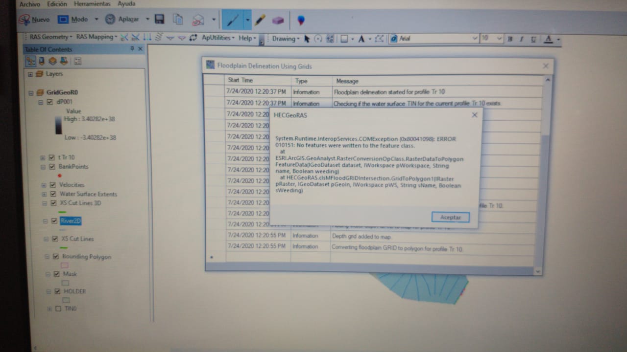
I am using ArcGIS 10.6 and HEC-GeoRas 10.6. I need to create a GIS project; first I run my steady simulation in HEC RAS, exported all data from HEC-RAS and then exit the program. Next, in ArcGIS with GeoRAS I convert SDF to XML file, set up my layer, create the new analysis and do a water surface generation, all good without problems. Finally, when I choose: "Floodplain delineation using rasters" I get this error:
System.Runtime.InteropServices.COMException(0x80041098):ERROR 010151: No features found in C:\........\Steady_PF\fdtemp.shp. Possible empty feature class.
at ESRI.ArcGIS.GeoAnalyst.RasterConversionOpClass.RasterDataToPolygonFeatureData(IGeoDataset dataset, IWorkspace pWorkspace, String name, Boolean weeding)
at HECGeoRAS.clsMFloodGRIDIntersection.GridToPolygon1(IRaster pRaster, IGeoDataset pGeoIn, IWorkspace pWS, String sName, Boolean sWeeding)
I can't solve it, can somebody help me please?
Thank you so much!
#hec ras #hec geo ras #geo hec-ras #hec-ras #hydro #flood mapping #HydroTools
- Mark as New
- Bookmark
- Subscribe
- Mute
- Subscribe to RSS Feed
- Permalink
Estefania,
Looks like you got your cross sections to come into ArcGIS. Make a TIN using your cross sections as a contour data type and the water surface elevation field as the elevation source. Convert the output TIN to a raster with the same cell size as your DEM. Looks like your DEM might also be a TIN. If so, convert this to a raster as well. Use the Minus tool in Spatial Analyst to get the difference, which will also be a raster. Create a contour using Contour List at an elevation of zero. This line indicates where the terrain elevation is equal to the water surface elevation. It also represents the floodplain boundary as a line. If you connect the endpoints of this line to make a closed polygon, you can then convert it to a floodplain polygon and edit it accordingly.
You can put this into Model Builder to help you automate the process for future iterations.
Hope this helps,
Kurt Baron
- Mark as New
- Bookmark
- Subscribe
- Mute
- Subscribe to RSS Feed
- Permalink
Hi Kurt, do you happen to know what exactly causes this error? What exactly is 'fdtemp.shp' and why does it show up empty? I tried running the same tool and had the same error, the process crashes at the step "Converting floodplain GRID to polygon for profile (name)" and then it says "Could not convert Grid to Polygon! for profile (name)". If the process crashed here, would it not imply that the process was successful up to the subtraction of the contour grid and water surface grid? And if this were the case, is it possible to take the data from the output grid of the subtraction and use the Raster to Polygon tool to create the polygon in the Arcmap? Thanks in advance.
Best regards,
Kevin