- Home
- :
- All Communities
- :
- Industries
- :
- Water Resources
- :
- Water Resources Questions
- :
- Longest Flow Path for Catchments error 010429
- Subscribe to RSS Feed
- Mark Topic as New
- Mark Topic as Read
- Float this Topic for Current User
- Bookmark
- Subscribe
- Mute
- Printer Friendly Page
Longest Flow Path for Catchments error 010429
- Mark as New
- Bookmark
- Subscribe
- Mute
- Subscribe to RSS Feed
- Permalink
I can't seem to get Longest Flow Path for Catchments in ArcHydro to successfully work, as I keep receiving 010429 and 010067 errors when I run it. Does anyone know how to prevent this from happening? I am using ArcGIS 10.6.1 on Windows 10 and the latest version of ArcHydro (10.6.0.13). Although I am new at using ArcHydro, there aren't many inputs for this tool, so I don't understand what I could be doing incorrectly. I've some of the suggestions here, to no avail. Attached is a screenshot of the error message I receive as well as the watersheds and flow lines I was able to delineate for the project I am currently working on.
- Mark as New
- Bookmark
- Subscribe
- Mute
- Subscribe to RSS Feed
- Permalink
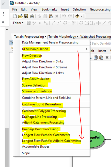
Looking at your watershed boundaries and points, it seems odd that there are two points in each watershed (polygon) as well as two drainage lines (blue polylines). If the points are centroids, then there is something wrong. The "two points inside each polygon" is so consistent, it makes me think that maybe you change the number of cells in the stream definition an didn't rerun some other part of the Basic Dendritic Terrain Processing functions
If the polygons are the catchment layer, then I'd check to make sure everything is correct at that step.
Flying in the blind here since I don't know everything about your project, but if you redo any step before the step you are one, you have to redo all the steps in between. There's a good chance you didn't do this, but maybe there is something is a process before the longest flow path routine that is not finishing.
I've inserted a screen capture and highlighted just the steps I use. They have to be done in order and if you re-do any step, you must redo all the following steps.
Heading out of town with limited ability to follow this. Hope you figure it out!
- Mark as New
- Bookmark
- Subscribe
- Mute
- Subscribe to RSS Feed
- Permalink
I went through all of those steps once again in order and still got stuck on Longest Flow Path for Catchments. In the image I posted I had the adjoint catchments turned by accident, which is why it looked like there were two centroids per catchment.
- Mark as New
- Bookmark
- Subscribe
- Mute
- Subscribe to RSS Feed
- Permalink
Try to use the Python version of the Longest Flow Path for Adjoint Catchments tool under the Arc Hydro Tools Python toolbox. It skips the Longest Flow Path for Catchments step which is problematic for large rasters (memory leak). To support LFP for Watershed, you do not need the LFP for Catchments, only the LFP for Adjoint Catchments.
Christine Dartiguenave
Esri Water Resources Team
- Mark as New
- Bookmark
- Subscribe
- Mute
- Subscribe to RSS Feed
- Permalink
That doesn't work either. Longest Flow Path for Adjoint Catchments requires the output from Longest
Flow Path for Catchments, as seen below. 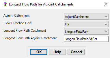
If I try to run Longest Flow Path for for Adjoint Catchments using the output I got from Longest Flow Path for Catchments or Drainage Lines, an error message pops up: "No corresponding flowpath found for catchments!". Is there a workaround I should be aware of to avoid this?
- Mark as New
- Bookmark
- Subscribe
- Mute
- Subscribe to RSS Feed
- Permalink
You need to use the geoprocessing tool from the Arc Hydro Tools Python toolbox (under Terrain Preprocessing Toolset).
:
- Mark as New
- Bookmark
- Subscribe
- Mute
- Subscribe to RSS Feed
- Permalink
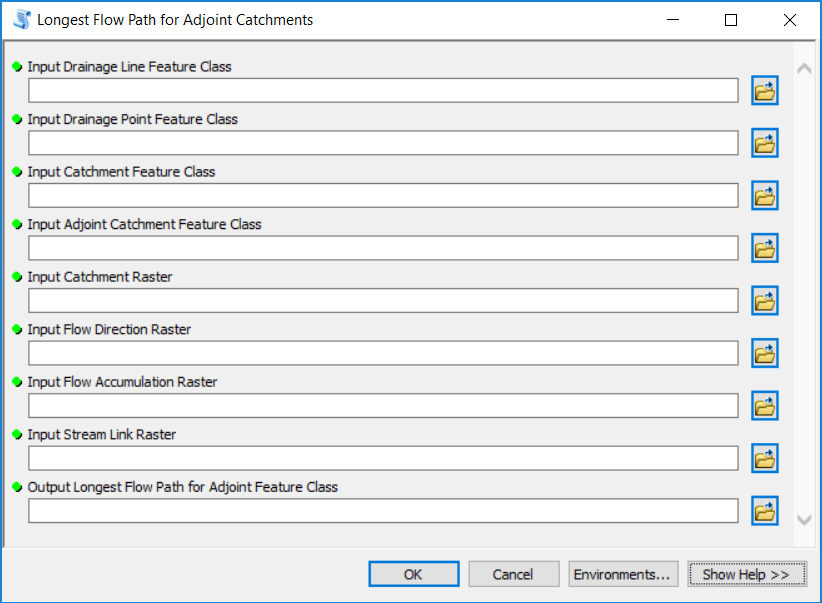
I see that the Python tool for LFP for Adjoint Catchments also requires LFP for Catchments as input. Was this with a different version? Has the memory leak been addressed? I'm still getting an error like this.
- Mark as New
- Bookmark
- Subscribe
- Mute
- Subscribe to RSS Feed
- Permalink
Were you able to solve this? I am getting the same error message repeatedly. Cannot get past this step.
Thanks