- Home
- :
- All Communities
- :
- Industries
- :
- Water Resources
- :
- Water Resources Questions
- :
- Hec-geoRas error
- Subscribe to RSS Feed
- Mark Topic as New
- Mark Topic as Read
- Float this Topic for Current User
- Bookmark
- Subscribe
- Mute
- Printer Friendly Page
- Mark as New
- Bookmark
- Subscribe
- Mute
- Subscribe to RSS Feed
- Permalink
I have a problem with the geometric data made with HEC-geoRAs and exported to HEC-RAS. Please help me, I do all the step with geoRAS, I assigned channel ID, left rght and center to Flowpath ecc... Any idea? Sorry for my english, I'm italian student.
ps: I understood that the Y and Z coordinates when I extract the sections are reversed
- Mark as New
- Bookmark
- Subscribe
- Mute
- Subscribe to RSS Feed
- Permalink
What does it look like in GeoRAS (ArcMap)?
- Mark as New
- Bookmark
- Subscribe
- Mute
- Subscribe to RSS Feed
- Permalink
I know this is an older post but I got a headache trying to figure out what was wrong so I wanna leave this here in case anyone is struggling with the same issue, I found a solution in this post:
Problem with import in HEC-GeoRAS / RAS - Floodplain Mapping
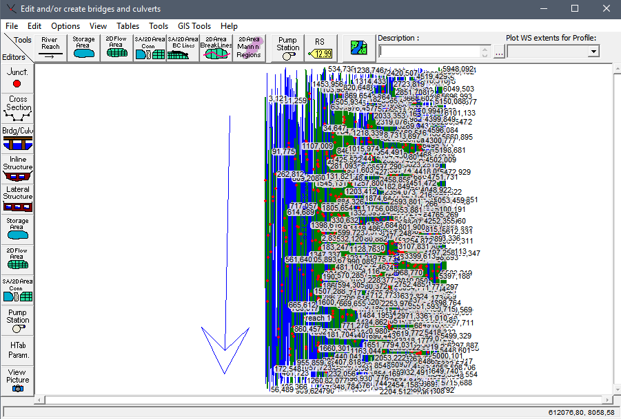
The problem is all the HEC GEO RAS files look fine in ArcGIS but when you export them and then import them as GIS data to HEC-RAS, the river displayed is completely wrong, it loses all form and shape. The core of the problem seems to be that HEC-RAS is somehow misreading the file's coordinates.
As said in the post I linked above, this may happen to some of us if our computer's regional settings use the character comma ',' as a decimal sparator, instead of the dot or period character '.' , as a result, the coordinates in our exported file will have their decimals separated by commas, but each coordinate (X, Y and Z) will also be separated by a comma, acompanied by a blank space.
Take the following set of coordinates:
X: 10.444
Y: 15.25
Z: 30
In arcmap, HEC GEO-RAS will export these coordinates as follows:
10'decimal separator'444 , 15'decimal separator'25 , 30
Normally, HEC-RAS should read these coordinates properly, however, if your decimal separator happens to be a comma, then HEC-RAS will read those coordinates the following way:
X: 10
Y:444
Z:15
So we know this is completely wrong, and it explains why the imported GIS data makes the river look like such a mess in the Geometric Data display.
The fix is to change those decimal separator commas to period characters, you can do this in a text editor, now, when you replace all commas with periods, you will also be changing the coordinate separating commas to periods as well, my fix for that problem was:
Right click your .sdf file and select 'Open with' --> Open the .sdf file with Microsoft Excel --> Select the column where the coordinates are placed (it was column B for me) and in the Start Menu, locate the Replace tool.
First, replace all commas in B column with the dot or period character '.'
Now all your commas have turned into periods, but you still need each coordinate (X, Y and Z) to be separated form each other by a comma and a blank space, so you need to select B column again, use the Replace tool, and replace all Periods followed by a blank space with commas followed by a blank space, that way, your periods acting as decimal separators will not be changed back into commas, but those periods that are followed by a blank space, therefore being the coordinate separators, will become commas and now HEC-RAS will be able to properly import your data.
Again, checking the decimal separator seems like an obvious thing to do but I honestly could not figure it out by myself, so I hope this can help someone out.
Cheers!
- Mark as New
- Bookmark
- Subscribe
- Mute
- Subscribe to RSS Feed
- Permalink
Very helpful your idea, thanks! I changed the regional settings as you suggested, then closed all the software, re-exported the geometry in ArcGIS to HECRAS format, opened it in HEC RAS and finally all worked.