- Home
- :
- All Communities
- :
- Industries
- :
- Water Resources
- :
- Water Resources Questions
- :
- Channel LongestFlowPath - True length?
- Subscribe to RSS Feed
- Mark Topic as New
- Mark Topic as Read
- Float this Topic for Current User
- Bookmark
- Subscribe
- Mute
- Printer Friendly Page
Channel LongestFlowPath - True length?
- Mark as New
- Bookmark
- Subscribe
- Mute
- Subscribe to RSS Feed
- Permalink
I'm looking for input or other's experience on an approach to smoothing the LongestFlowPath polylines so that the Shape_Length is more accurate. I am comparing a recent Arc Hydro analysis with a past manual effort. I'm finding that the LongestFlowPath as calculated by the Shape_Length is much greater than that measured by hand.
Supposedly something measured using GIS would be more accurate than measuring the same thing by hand: at least more precise and repeatable. In the past, an engineer's scale or wheel was used to measure the LongestFlowPath (L) on paper topo or a USGS quad map. However, when using GIS in my test case, L goes from 5.25 miles measured manually to 6.1 miles using Arc Hydro! A separate manual measurement was done by a third party and they recorded 5.6 miles.
This length L and the CentroidalLongestFlowPath (Lca), which is base on the L, are used in our lag equation. So, I am forced to study the GIS process to determine what's up.
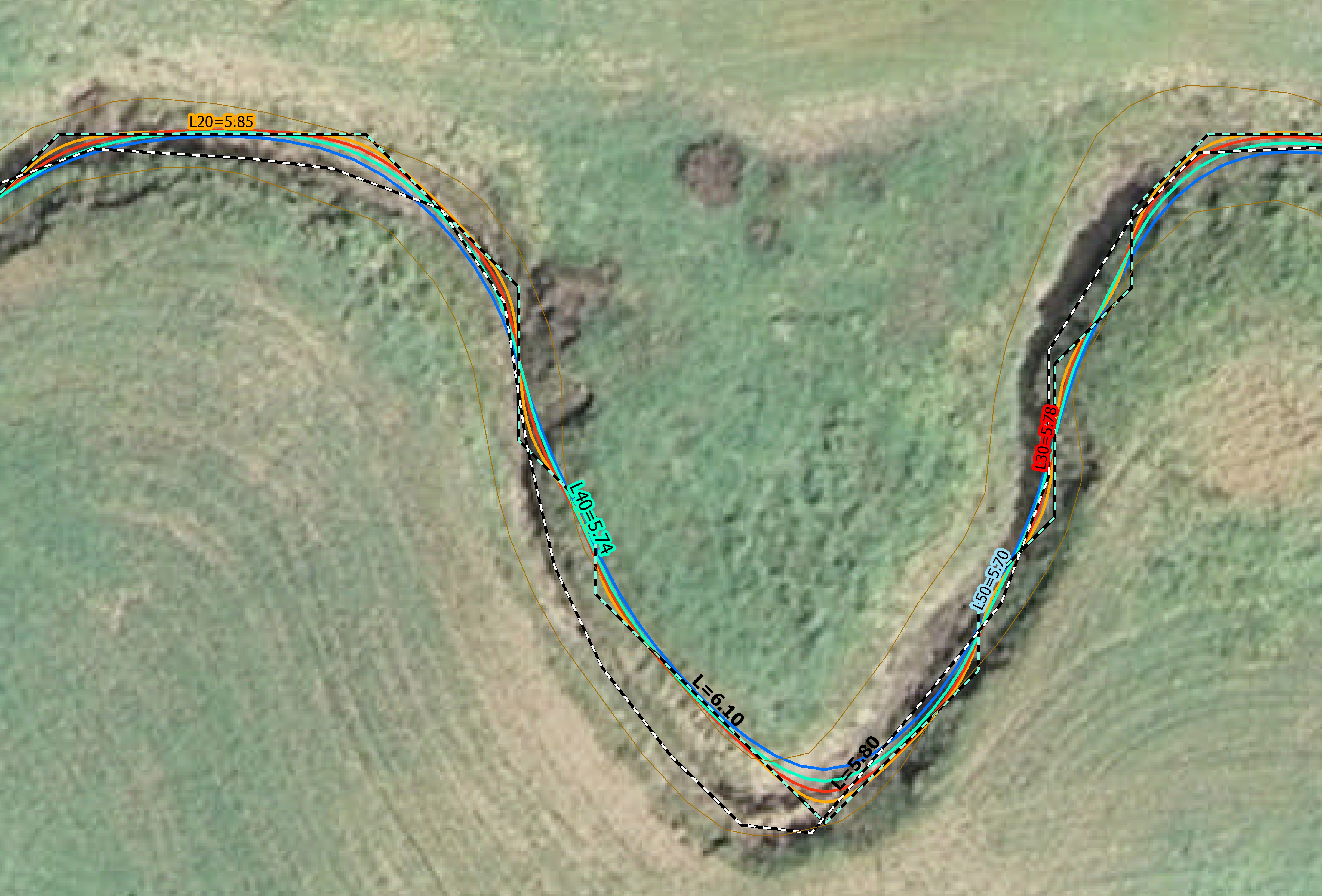
I reviewed the polyline visually and found that because the polyline "bounces" around from DEM grid center to grid center, it is longer. The bouncing is most notable when the bearing on the creek is at 45 deg. There are places where GIS more accurately follows the creek than hand measurement and that is good. A past effort totally cut across an oxbow. I want the GIS analysis to more closely follow the "hand" method because the equations were developed a long time ago when "human error" was a part of process.
I have used the Cartography Tools.tbx\Generalization\Smooth Line tool to see what level of smoothing could be acceptable. I want to establish a standard practice so that the results from GIS are more accurate than by hand, but that the precision doesn't get so good that it overestimates the L.
In the PAEK method under this tool there is a smoothing tolerance. I've run the PAEK method with various values to determine which value does what I want without overdoing it. The attached jpg shows the original L (dashed) compared to smoothed polylines using tolerances of 20ft, 30ft, and 50ft. I also ran it with 100ft just to see the far end of the spectrum of results. The DEM is 10' x 10'.
I am wondering if anyone else has dealt with this issue.
Thanks.
Mark
PS - In the attachment there are two dashed lines. The dashed line with light green is the original L from Arc Hydro with a length of 6.1 mi. The second one with white was done manually in GIS and has a length of 5.8 miles.