- Home
- :
- All Communities
- :
- Industries
- :
- Water Resources
- :
- Water Resources Questions
- :
- ArcHydro Problem Solvers
- Subscribe to RSS Feed
- Mark Topic as New
- Mark Topic as Read
- Float this Topic for Current User
- Bookmark
- Subscribe
- Mute
- Printer Friendly Page
ArcHydro Problem Solvers
- Mark as New
- Bookmark
- Subscribe
- Mute
- Subscribe to RSS Feed
- Permalink
- Make sure the Geoprocessing extents include the whole project: Go to the Geoprocessing menu>Environments...>Processing Extent. Under Processing Extent choose a layer that you know covers the full extent of the waters you are processing and click OK. This should ensure that the processing extent is large enough to do what you want.
- Delete everything you can in your temp folder: Mine is C:\Users\mboucher\AppData\Local\Temp. Get out of ArcMap first to clear temp files related to your project. You can do this without getting out of ArcMap through the ArcHydro Toolbar under ApUtilities>Additional Utilities>Clean User's Temp Folder.
- Make sure your Target Locations are correct: Under ApUtilities>Set Target Locations, make sure the HydroConfig and they GeoHMSConfig Targets make sense. The raster data should go to the project folder vector data to a geodatabase. The raster data will go to a folder in the project folder with the dataframe name and the vector data to a feature data set with the dataframe name. Through the ArcHydro Toolbar under there is a function to reset the target locations: ApUtilities>Additional Utilities>Reset Target Locations. I've not tested this to see if it corrects everything.
- When working on a complicated model, don't use the model mxd for your presentation map. It just adds baggage to an already "heavy" mxd.
Solved! Go to Solution.
- Mark as New
- Bookmark
- Subscribe
- Mute
- Subscribe to RSS Feed
- Permalink
I've started a practice that seems to make many errors/crashes go away.
Layers/rasters needed for Arc Hydro are:
- DEM PROCESSING:
- rawdem (Extracted by mask from county-wide dem for each project. Set processing extents using this or mask ploly)
- agreestream*
- innerwalls*
- outerwalls*
*I do work all over my County and so have county-wide "master" geodatabase for these that I use on all my Arc Hydro Projects.
- WATERSHED DELINEATION:
- BatchPoints
If I have these layers, I can recreate the hydrologically correct DEM (HC DEM) anytime I want and re-delineate the watersheds.
So my practice is this: As I'm developing my HC DEM, and have to modify the agreedem, innerwalls, outerwalls layers, I can save the BatchPoints to my project folder and then delete the geodatabase and folder with rasters in it (Target Locations). This starts everything fresh and new. Then I can use model builder to reprocess the watersheds. When I'm ready to re-delineate the watersheds, I copy the BatchPoints into the geodatabase and set the BatchDone value to "0".
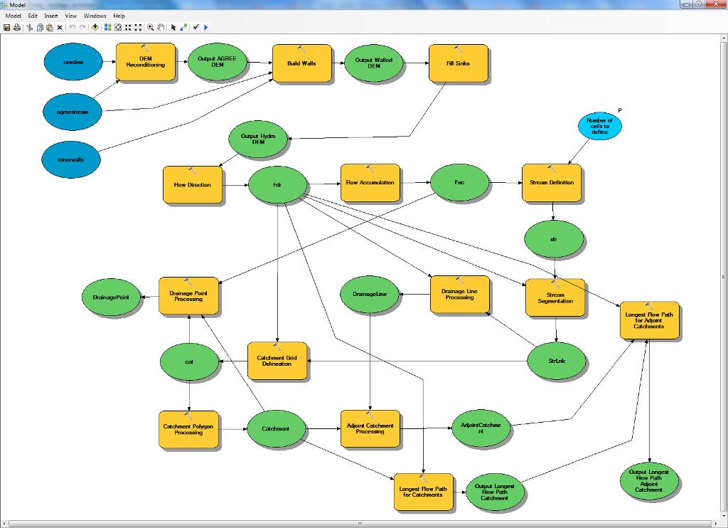
I run the watershed delineation, etc. via the Arc Hydro menus though I could possibly do this via Model Builder also. Since I've started doing this (and following solutions in the postings above on this thread), my crashes and errors have all gone away! Here is the ModelBuilder model for my latest project. I don't use outerwalls on this project, but that could be added.
[ATTACH=CONFIG]18585[/ATTACH]
- Mark as New
- Bookmark
- Subscribe
- Mute
- Subscribe to RSS Feed
- Permalink
http://forums.arcgis.com/threads/40476-Windows-Professional-64-bit-and-ArcHydro-Bugs-encountered?p=2...
- Mark as New
- Bookmark
- Subscribe
- Mute
- Subscribe to RSS Feed
- Permalink
my thanks for reply.
The matter is that befor I applyed the Forum I have read information there and deleleted all files from directory by using "Clean Usre's Temp Folder". But these actions didn't help. I simply don't know what to do.
Now I again clean this folder , but have got the same negative result.
Please, advise me what I have to do more.
Besty regards
Yury
- Mark as New
- Bookmark
- Subscribe
- Mute
- Subscribe to RSS Feed
- Permalink
http://forums.arcgis.com/threads/68360-Error-in-DEM-Reconditioning-in-Arc-hydro-10?p=245919#poststop
- Mark as New
- Bookmark
- Subscribe
- Mute
- Subscribe to RSS Feed
- Permalink
- Mark as New
- Bookmark
- Subscribe
- Mute
- Subscribe to RSS Feed
- Permalink
http://forums.arcgis.com/threads/76491-unable-to-recondition-or-burn-stream-into-raster?p=268404#pos...
- Mark as New
- Bookmark
- Subscribe
- Mute
- Subscribe to RSS Feed
- Permalink
http://help.arcgis.com/en/arcgisdesktop/10.0/help/index.html#/Understanding_drainage_systems/009z000...
However, I have to disagree with the flow chart in this link (part of the same series). I would always perform a fill before running the flow direction. There is something wrong with the flow chart. It should show the process going from the dimensionless DEM box to a flow direction step then to the flow accumulation. Sorry, I'm being a little picky here, but someone new to this could get frustrated by the flowchart. The steps I use are posted and/or linked elsewhere in this thread (see post #2 in the post right before this one).
http://help.arcgis.com/en/arcgisdesktop/10.0/help/index.html#/Deriving_runoff_characteristics/009z00....
The third paragraph in this link (part of the same series) points out that most DEMs have sinks. Mine always do, hence, why I always would run a fill sink process before I run the flow direction.
http://help.arcgis.com/en/arcgisdesktop/10.0/help/index.html#/How_Fill_works/009z00000061000000/
- Mark as New
- Bookmark
- Subscribe
- Mute
- Subscribe to RSS Feed
- Permalink
I've been teaching myself Arc Hydro Tools using this walkthrough from Purdue University, using the data provided in the zip file: http://web.ics.purdue.edu/~vmerwade/education/terrain_processing.pdf
Even after making the adjustments recommended in this thread, I would say 50% of the time I get an error message similar to the one seen in the top link. The other half of the time, I get a Flow Direction raster that has no attributes. Any ideas what the heck is going on or how to rectify this situation?
Thanks!
- Mark as New
- Bookmark
- Subscribe
- Mute
- Subscribe to RSS Feed
- Permalink
Getting a project started:
- For fastest processing, put the project directory on your local computer (C: drive). Processing over a network kills your speed.
- Keep the layer, file, and directory names short and with no spaces or non-alpha numeric characters. Use "_" if you must. I don't use "-". I suspect it causes problems.
- Make sure the HydroConfig Target Locations are correct. If you start the project and then move it to another folder, the Target Locations will not change on their own. The GeoHMSConfig Target Locations should be checked if using GeoHMS. Use the ApUtilities > Additional Utilities>Reset Target Locations menu command to reset them. I always check them under ApUtilities>Set Target Locations.
- Make sure the Spatial Analyst extension is selected under Customize>Extensions.
- Make sure your Geoprocessing Extents match the area you want to process. Use Geoprocessing>Environments>Processing Extent menu command. I make it match the DEM or the mask I used to extract the DEM for the project. In doing batch point delineation I've had this change to the batch point extent and produce puzzling results.
- Disable Background Processing via Geoprocessing>Options menu.
- Set the "Max number of unique values to render" to a high number (I use 30,000,000: Don't ask me why.) Adjust this setting under Customize>ArcMap Options>Raster tab>Raster Dataset tab.
- Putting the agreestream, innerwall and outerwall layers in a geodatabase is a good idea.
- If you are starting over on the process after getting much of the way through it, close Arc Map and via Windows Explorer delete the folders (would have the same name as your data frame) and the geodatabase (would have the same name as your mxd). This makes sure there are not locks on layers/rasters and no denials for overwriting files. The only layer I copy out of this is the Batch Point layer. I make a copy in the main directory so I don't have to create them again.
- Clear out the temp file directory. Do this as often as you think of it. There's a tool under ApUtilities that does this nicely.
- At times, a reboot of the PC does wonders. I'm not sure why this helps other than it might eliminate software conflicts if you are using more than one program.
Word Version Attached:
- Mark as New
- Bookmark
- Subscribe
- Mute
- Subscribe to RSS Feed
- Permalink
http://forums.arcgis.com/threads/71180-Error-when-DEM-reconditioning?p=255178&viewfull=1#post255178