- Home
- :
- All Communities
- :
- Industries
- :
- Water Resources
- :
- Water Resources Questions
- :
- Arc Hydro Watershed Delineation
- Subscribe to RSS Feed
- Mark Topic as New
- Mark Topic as Read
- Float this Topic for Current User
- Bookmark
- Subscribe
- Mute
- Printer Friendly Page
Arc Hydro Watershed Delineation
- Mark as New
- Bookmark
- Subscribe
- Mute
- Subscribe to RSS Feed
- Permalink
Any help would be greatly appreciated thanks, [email protected]
- Mark as New
- Bookmark
- Subscribe
- Mute
- Subscribe to RSS Feed
- Permalink
Check out the Arc Hydro forum sticky "Arc Hydro Problem Solvers Thread" for other helpful tips.
- Mark as New
- Bookmark
- Subscribe
- Mute
- Subscribe to RSS Feed
- Permalink
1. Local delineation within the extent of the Catchment in which your point is located (this is probably your current end result)
2. If your point is located on a DrainageLine/Str, the local delineation is merged with the related AdjointCatchment feature.
If you rerun Adjoint Catchment Processing you should be able to get the correct delineations.
Christine Dartiguenave
Esri Water Resources Team
- Mark as New
- Bookmark
- Subscribe
- Mute
- Subscribe to RSS Feed
- Permalink
I'm having what I think is a similar issue. I'm deliniating from batch points. They are all aligned with the Drainage Line and were snapped, but many of the watersheds are left off. I can trace flow and downstream/upstream with all the works fine. I've re-run all the steps and am still getting the problem. The attached image shows my watersheds. Blue points are the batch points. Notice that the red traces seem to be fine using the flow path tracing tool. But, when I tried to do a spot deliniation on top of one of my batch points it does the same thing as the batch points. The center watershed that is not included is interesting, why would it cut it in half life that?
I will reset the extents and see if it helps, but I'm not convinced that is the issue. Any other ideas?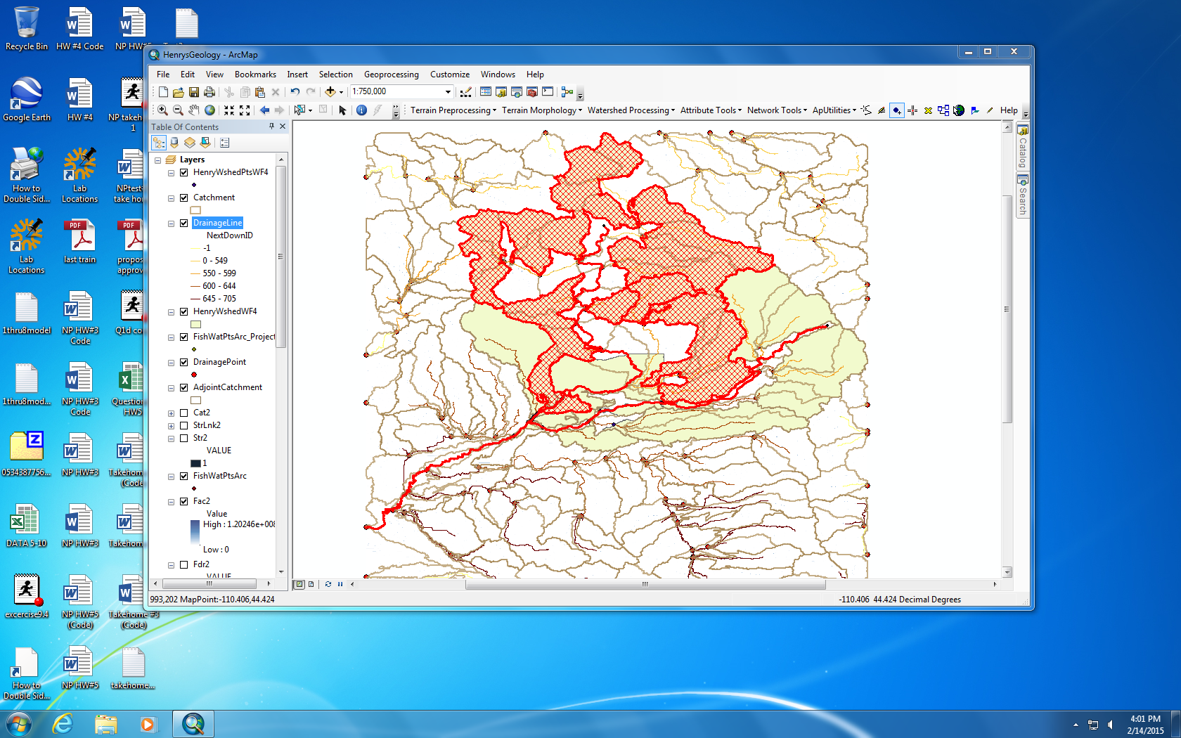
- Mark as New
- Bookmark
- Subscribe
- Mute
- Subscribe to RSS Feed
- Permalink
I now recall a big project I worked on a few years ago. It was a batch subwatershed delineation problem, not an adjoint catchment problem.
After finding the batch subwatershed delineation not working for some points, I started doing the batch subwatershed delineation in groups. I found when I did this I got acceptable results. It was frustrating since my work was somewhat iterative - I'd run the process, see a needed change, and run it again. I think I created a new field in the batch point table with 1, 2, 3, etc. in the field for the different batch point groups I wanted to run. Then, maybe using model builder (that's what I would do today), I selected a group based on that field, ran the batch subwatershed delineation, selected the next group, ran it again, etc. At some point I found how to group them to get a successful process.
This was a long time ago in Arc Hydro 9.x. I may not have been working off the local drive, and I've learned a bunch more since then. Point is, I don't know if it was a problem with that version or my approach to "managing the monster" that was causing the problem.
- Mark as New
- Bookmark
- Subscribe
- Mute
- Subscribe to RSS Feed
- Permalink
The problem here, though, is that none of the watersheds are working because the upstream catchments are full of holes where watersheds haven't been included in the adjoint catchments and thus aren't included in the final batch point watersheds either. I have done a single watershed in the above image (see the hatched, red area) and it doesn't help.
- Mark as New
- Bookmark
- Subscribe
- Mute
- Subscribe to RSS Feed
- Permalink
Can you post the catchment/drainage lines and adjoint catchments?
Christine
- Mark as New
- Bookmark
- Subscribe
- Mute
- Subscribe to RSS Feed
- Permalink
Here is a dropbox link to the files. Is there a better way to post them?
- Mark as New
- Bookmark
- Subscribe
- Mute
- Subscribe to RSS Feed
- Permalink
Ok, finally success!! I found access to a machine running 10.1 and had an admin install Arc Hydro. This solved the problem completely. Whether this had to do with the actual version, or the fact that the other one was on a networked lab computer, it is hard for me to say. Anyway, I've now got a layer full of watersheds that make sense.
Still, if you can find a reason why this happened it would be invaluable to know since I don't always have access to the computer I used today.
- Mark as New
- Bookmark
- Subscribe
- Mute
- Subscribe to RSS Feed
- Permalink
No love with changing the extents. I also went through all of the steps in your troubleshooting guide Mark Boucher, including remaking the geodatabase. This seems to be a similar problem to what is being talked about in this thread:
ArcGIS 10.0 Adjoint Catchment toolbox bug?
That one was solved by updating to a new version of Arc, but I am using 10.2.2 which is beyond the version in that thread. Also, I can't update versions as I'm using the software on lab computers.
Any ideas? This is becoming a very frustrating project that was supposed to only take a couple days and has ate up a week now of trying and failing, grrr...
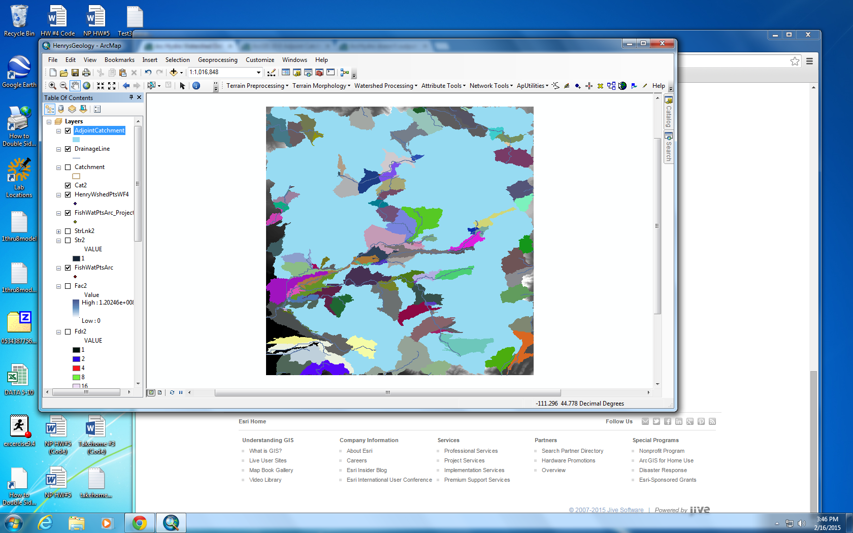
The pic below shows the adjiont catchments in blue and the catchment raster layer in multiple colors. It is definitely the Adjoint catchment step that is messing up. I have gone through the attribute tables for Drainage Lines and Catchment layers and at least the NextDown ID's appear to be correct. Also, if you look at this screenshot compared to the first one there is something different. First, it seems to be leaving out watersheds over the main rivers in the network and only creating Adjoint Catchments for minor tributaries to them, that seems like an interesting point, though I don't know what it would mean.