- Home
- :
- All Communities
- :
- Industries
- :
- State & Local Government
- :
- State & Local Government Questions
- :
- Re: Spatial Join - Poly->Poly - Overlapping
- Subscribe to RSS Feed
- Mark Topic as New
- Mark Topic as Read
- Float this Topic for Current User
- Bookmark
- Subscribe
- Mute
- Printer Friendly Page
- Mark as New
- Bookmark
- Subscribe
- Mute
- Subscribe to RSS Feed
- Permalink
The attached screenshot, shows two flood zones (AE-6 & AE-7). The numeral in the flood zone identifier represents the flood elevation level. Also shown are the building footprints.
Using spatial join with the match Option set to "Completely within" easily associated all these buildings with the proper flood elevation,
However, when buildings straddle the flood zone boundary line (see selected footprints in the attached graphic), I haven't figured-out how to get the spatial join to identify the proper flood elevation; in this case "7" feet as opposed to "6" feet. (When a flood zone boundary line touches a building to any degree, the entire building is considered in the higher regulated zone.)
Any suggestions?
Thanks,
Scott
Solved! Go to Solution.
Accepted Solutions
- Mark as New
- Bookmark
- Subscribe
- Mute
- Subscribe to RSS Feed
- Permalink
Try the following, using the Spatial Join Tool in ArcMap or Pro:
1) SetTarget Features - Buildings
2) Set Join Features - FloodZones
3) Set your output Feature Class
4) Join Operation - JOIN_ONE_TO_ONE
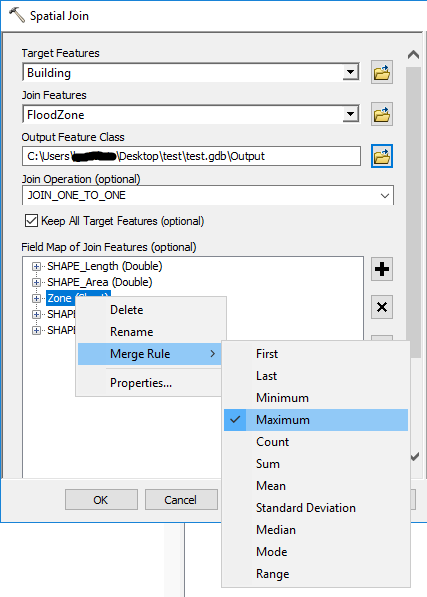
5) In the Field Map section
ArcMap
Right click on the name of your Zone attribute in your FloodZone feature
Select - Merge Rule > Maximum
You can also remove any fields that you do not need from the Field Map using the "X" button.
Pro
Select the name of your Zone attribute in your FloodZone feature
Set the Merge Rule to Maximum
You can also remove any fields that you do not need from the Field Map by right clicking.
Set the Match Option to Intersect
6) Run the Join
10.7 ArcMap

2.4 Pro
The resultant joined feature class will have the Maximum value assigned from the FloodZone to the Building.
- Mark as New
- Bookmark
- Subscribe
- Mute
- Subscribe to RSS Feed
- Permalink
Try the following, using the Spatial Join Tool in ArcMap or Pro:
1) SetTarget Features - Buildings
2) Set Join Features - FloodZones
3) Set your output Feature Class
4) Join Operation - JOIN_ONE_TO_ONE
5) In the Field Map section
ArcMap
Right click on the name of your Zone attribute in your FloodZone feature
Select - Merge Rule > Maximum
You can also remove any fields that you do not need from the Field Map using the "X" button.
Pro
Select the name of your Zone attribute in your FloodZone feature
Set the Merge Rule to Maximum
You can also remove any fields that you do not need from the Field Map by right clicking.
Set the Match Option to Intersect
6) Run the Join
10.7 ArcMap

2.4 Pro
The resultant joined feature class will have the Maximum value assigned from the FloodZone to the Building.
- Mark as New
- Bookmark
- Subscribe
- Mute
- Subscribe to RSS Feed
- Permalink
Oh Sweet!
That worked first time like a charm.
For you to include an instructive graphic (I am using Pro) was above and beyond.
Thank you,
Scott