- Home
- :
- All Communities
- :
- Industries
- :
- State & Local Government
- :
- State & Local Government Questions
- :
- Land Use Public Notification - selection changes a...
- Subscribe to RSS Feed
- Mark Topic as New
- Mark Topic as Read
- Float this Topic for Current User
- Bookmark
- Subscribe
- Mute
- Printer Friendly Page
Land Use Public Notification - selection changes after export.
- Mark as New
- Bookmark
- Subscribe
- Mute
- Subscribe to RSS Feed
- Permalink
Hello again.
In my quest to implement the Land Use Public Notification app I am seeing some weird behavior with the graphics that highlight the selected property.
I am able to select a property and click on the envelope to begin exporting the mailing labels. After I fill out the form and click "Download" the red buffer graphic comes up but the original selected parcel jumps to another parcel that the buffer intersects. See pic -
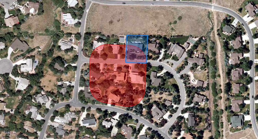
The original selection was the parcel in the middle of the buffer. It jumped to the one on the northeast corner after "Download" was clicked.
Is this a bug? Can I fix it? Jake Skinner
Thanks for any help.
Jeff
Summit County, Utah
- Mark as New
- Bookmark
- Subscribe
- Mute
- Subscribe to RSS Feed
- Permalink
Hi Jeff,
What is the projection of the map service you are using?
- Mark as New
- Bookmark
- Subscribe
- Mute
- Subscribe to RSS Feed
- Permalink
I have an imagery cache and the taxparcelquery service. Both are in Web Mercator.
Summit County, Utah
- Mark as New
- Bookmark
- Subscribe
- Mute
- Subscribe to RSS Feed
- Permalink
Any thoughts Jake Skinner?
Summit County, Utah
- Mark as New
- Bookmark
- Subscribe
- Mute
- Subscribe to RSS Feed
- Permalink
If the app is external, would you be able to share the link?
- Mark as New
- Bookmark
- Subscribe
- Mute
- Subscribe to RSS Feed
- Permalink
It is not external, but I could send you the app folder if that would help.
Summit County, Utah