- Home
- :
- All Communities
- :
- Products
- :
- Standards and Interoperability
- :
- Standards and Interoperability Questions
- :
- Generate Roof Features through First Return DWG
- Subscribe to RSS Feed
- Mark Topic as New
- Mark Topic as Read
- Float this Topic for Current User
- Bookmark
- Subscribe
- Mute
- Printer Friendly Page
Generate Roof Features through First Return DWG
- Mark as New
- Bookmark
- Subscribe
- Mute
- Subscribe to RSS Feed
- Permalink
I currently have two layers: building footprints and First Return lidar data. I was able to extract individual building parts through reclassification, but the output-polygon is too pixel-like because of the DWG resolution.
Any ideas on how I can simplify the output to create smooth vector features (i.e. w/ generalized lines and right angles)? I have tried using the 'Regularize Building Footprint' gdp tool, but it does not handle topological errors. I have also tried using the 'Simplify Polygon' tool, but i ends up creating wacky angles.

- Mark as New
- Bookmark
- Subscribe
- Mute
- Subscribe to RSS Feed
- Permalink
Hi Cyrus,
I've been working on this process a little bit. If you select the largest polygon inside the building footprint and run a regularize building footprint at right angles (or diagonal and right angles), then erase it from the original polygon and add them together to get separate polygons (multipart to singlepart). It's not perfect, then add heights to the polygons centroid, join back, divide by 5 and do a dissolve to get rid of small edges. It works fairly well on rectangles, but not as good on weird shaped buildings (circle,odd angles, etc).
You can also use the DSM clipped to the building footprint run through Segment Mean Shift and Raster to Polygon to get polygons like above.
Thanks,
Arthur Crawford - Esri
- Mark as New
- Bookmark
- Subscribe
- Mute
- Subscribe to RSS Feed
- Permalink
Hi Cyrus,
To add on to Art's response, we have identified the need for a regularization routine that honors shared polygon borders and maintains topology of the output, and are currently developing that functionality. This does add a significant amount of complexity to the algorithm, and is more computationally expensive, but we hope to include this ability soon.
In the meantime, I'll mention that the Integrate tool can be helpful to overcome topology errors introduced by the Regularize Building Footprint tool. Integrate—Data Management toolbox | ArcGIS for Desktop
Best of luck,
Dan Hedges
- Mark as New
- Bookmark
- Subscribe
- Mute
- Subscribe to RSS Feed
- Permalink
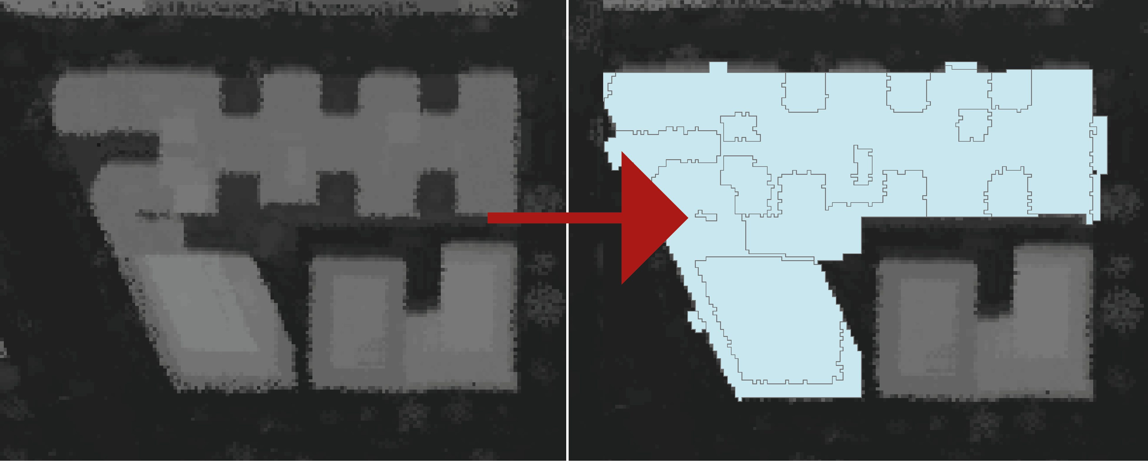
Here's an example of how far I got without the tool Dan references in development.
The tool should make this much easier to do.
Arthur Crawford - Esri