- Home
- :
- All Communities
- :
- Products
- :
- Spatial Data Science
- :
- Spatial Data Science Questions
- :
- Re: Raster/Vector Land use Analysis
- Subscribe to RSS Feed
- Mark Topic as New
- Mark Topic as Read
- Float this Topic for Current User
- Bookmark
- Subscribe
- Mute
- Printer Friendly Page
- Mark as New
- Bookmark
- Subscribe
- Mute
- Subscribe to RSS Feed
- Permalink
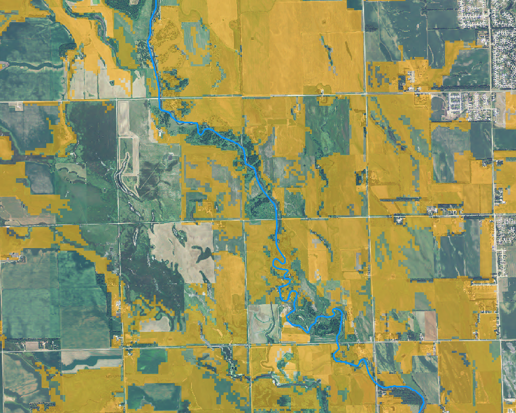
Hello all,
I'm trying to search for sites that are conducive to some of our land use objectives. I've been tasked with finding pastures (orange raster) that are on BOTH sides of the river (in blue). I know there's ways to extract areas that intersect the river, but I don't know how to make it so it queries locations that have it on both sides. Any suggestions?
Solved! Go to Solution.
Accepted Solutions
- Mark as New
- Bookmark
- Subscribe
- Mute
- Subscribe to RSS Feed
- Permalink
If you have access to an Advanced ArcGIS license and ET GeoWizards, here is a vector workflow that could be of use:
- If your data is raster, convert to vector.
- For your pasture polygons, create a new field in the attribute table for use as a unique ID. Populate it with unique ID's (Calculate equal to the FID field is the easiest
- Next, we will use the river lines to split the pasture polygons. Use ET Geowizards (third-party ArcGIS add-on) Split Polygons by Lines function. You can download their software and try it out - it is a free function. However, there may be a limit on how many features you can do. ArcGIS tools add-ons and extensions from ET SpatialTechniques
- Now that you have a split polygon result, run a Frequency based on the Unique ID field you created back in step #2. Frequency - ArcGIS Help (10.2, 10.2.1, and 10.2.2)
- Now do a query on all the Frequency count that are greater than one. These are the resulting polygons by Unique ID that have river on both sides. If there are only a few, you can manually correlate them to the pasture polygons you made. Otherwise, move on to the next step.
- One can do an Attribute Join to join of the Frequency result back to the pasture polygons feature class to then be able to query the result (Frequency Count greater than 1) and have the actual polygons select.
Edits - cleaned up the process order
Chris Donohue, GISP
- Mark as New
- Bookmark
- Subscribe
- Mute
- Subscribe to RSS Feed
- Permalink
Thanks Chris, looks like I have it well underway with your guidance!
- Mark as New
- Bookmark
- Subscribe
- Mute
- Subscribe to RSS Feed
- Permalink
Hi Matthew,
Case-1
If you want the pastures irrespective of how big they are.
1. Convert the Raster to vector (Unless you have Vectors of the same).
2. Export the pastures and river features to different layers.
3. Try Select by Location with Pastures as the target layer, and River as the source layer.
Spatial Selection Method = "Are within a Distance of"
Case-2
If you want the fraction of patches (say you want 500 meters on both sides of the river)
After step 1 and 2 of Case-1.
> Create a buffer using the river boundary for the required distance.
> Clip the Pastures layer using the above Buffer layer.
Hope it helps!!!
Think Location