Turn on suggestions
Auto-suggest helps you quickly narrow down your search results by suggesting possible matches as you type.
Cancel
- Home
- :
- All Communities
- :
- Products
- :
- Spatial Data Science
- :
- Spatial Data Science Questions
- :
- Re: Converting a raster to a polygon
Options
- Subscribe to RSS Feed
- Mark Topic as New
- Mark Topic as Read
- Float this Topic for Current User
- Bookmark
- Subscribe
- Mute
- Printer Friendly Page
Converting a raster to a polygon
Subscribe
3795
1
01-30-2014 01:34 PM
by
Anonymous User
Not applicable
01-30-2014
01:34 PM
- Mark as New
- Bookmark
- Subscribe
- Mute
- Subscribe to RSS Feed
- Permalink
Original User: Schack
I need to convert a raster into a polygon, and I ran into "Error 000863: Invalid GP Data Type"
After searching, I saw this solution online.
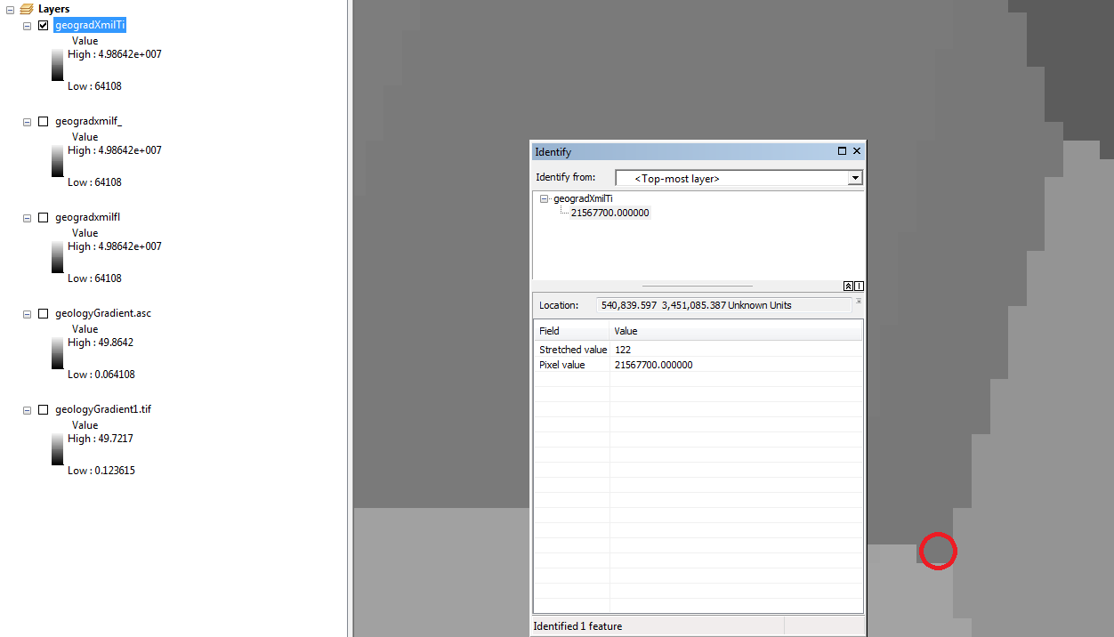
Basically I needed to convert the float raster to an integer raster. I used the times tool to multiply my raster by 1,000,000.0 to preserve all the decimal places. When I compare the resulting raster, it seems Arcgis has rounded the value for each pixel up by one (See the pixel values in the images below). I was hoping to preserve these exact values. Is there another approach I can try?
[ATTACH=CONFIG]31001[/ATTACH]
[ATTACH=CONFIG]31002[/ATTACH]
I need to convert a raster into a polygon, and I ran into "Error 000863: Invalid GP Data Type"
After searching, I saw this solution online.
Basically I needed to convert the float raster to an integer raster. I used the times tool to multiply my raster by 1,000,000.0 to preserve all the decimal places. When I compare the resulting raster, it seems Arcgis has rounded the value for each pixel up by one (See the pixel values in the images below). I was hoping to preserve these exact values. Is there another approach I can try?
[ATTACH=CONFIG]31001[/ATTACH]
[ATTACH=CONFIG]31002[/ATTACH]
1 Reply
by
Anonymous User
Not applicable
02-05-2014
12:19 AM
- Mark as New
- Bookmark
- Subscribe
- Mute
- Subscribe to RSS Feed
- Permalink
Original User: xander_bakker
Hi Aaron,
Sorry, but I have to ask; can you justify based on your data precision to be bothered by such a small difference (0.000001 is 0.00000464%)?
If so, what you could do is to determine the center point for the polygons (calculate geometry), convert these coords to a point featureclass, use the extract values by points on the original raster (before multiplying), join the result back to the polygons and overwrite the values.
Kind regards,
Xander