- Home
- :
- All Communities
- :
- Industries
- :
- Transportation
- :
- Roads and Highways
- :
- Roads and Highways Videos
- :
- ASSET EXTRACTION FROM MOBILE LIDAR: VIDEO 1
- Subscribe to RSS Feed
- Mark Topic as New
- Mark Topic as Read
- Float this Topic for Current User
- Bookmark
- Subscribe
- Mute
- Printer Friendly Page
ASSET EXTRACTION FROM MOBILE LIDAR: VIDEO 1
- Mark as New
- Bookmark
- Subscribe
- Mute
- Subscribe to RSS Feed
- Permalink
- Report Inappropriate Content
State DOT’s manage millions of valuable roadway assets, spread across hundreds of millions of acres. Inventorying assets in the field is costly and time-consuming, especially when accurate geolocation is included. Remote sensing may offer alternatives to field inventory, especially if the process can be automated through imagery classification. Unfortunately, many roadway assets—signage, signals, luminaires and guardrails, for example—present spectral profiles that are difficult or impossible to identify through automated classification of 2-dimensional photo imagery. Likewise, aerial lidar only captures an asset profile as seen from above. Mobile lidar captured from specially-equipped (often purpose-built) vehicles, on the other hand, captures rich, 3D representations of roadway assets, which may present new opportunities for identifying assets and their locations.
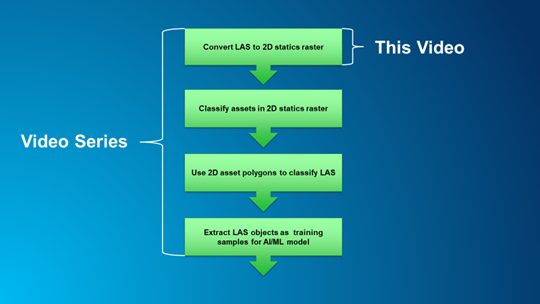
In this series of videos, I introduce a novel approach to extracting roadway assets from mobile lidar point clouds using the workflow pictured. This video will cover the first step in the workflow.
- Mark as New
- Bookmark
- Subscribe
- Mute
- Subscribe to RSS Feed
- Permalink
- Report Inappropriate Content
I just watched the first of what looked like four planned videos on feature extraction from mobile LIDAR (done in 2020), but I can't find the next three videos. I understand the whole process model is presented in the first video, but I would like to see the rest of the walk through. Were they done and where can I find them? Or were they removed as obsolete due to version updates since 2020?
- Mark as New
- Bookmark
- Subscribe
- Mute
- Subscribe to RSS Feed
- Permalink
- Report Inappropriate Content
Sorry, Elizabeth, but I was diverted from the project, and have since left Esri. I never got the chance to rigorously validate the technique. If you would like to speak to me about it, you can email me at pgiersjr@hotmail.com.