- Home
- :
- All Communities
- :
- User Groups
- :
- Roads and Highways User Group (RHUG)
- :
- Questions
- :
- Spur route start calibration
- Subscribe to RSS Feed
- Mark Topic as New
- Mark Topic as Read
- Float this Topic for Current User
- Bookmark
- Subscribe
- Mute
- Printer Friendly Page
- Mark as New
- Bookmark
- Subscribe
- Mute
- Subscribe to RSS Feed
- Permalink
Hi all,
I found some old discussion regarding this topic saying this was not supported and I believe that is still true but thought I would confirm.
I'm looking to see if it's possible to have the start calibration point of a route automatically update based on the measure of an intersecting route. Our specific use case is short divided highway sections. Currently they calibrate from measure 0, but it's far more useful to have the measure of the main upchain route. I do have an intersection feature class.

Solved! Go to Solution.
Accepted Solutions
- Mark as New
- Bookmark
- Subscribe
- Mute
- Subscribe to RSS Feed
- Permalink
Hello Colin
I've been following this thread and would like to provide some additional context. I understand you have main traversals (sometimes called trunk or inventory lines) which act conceptually as a measuring stick for certain other associated routes (in your case the partially divided opposite side routes) where you wish to derive the start measure as the measure of the main line where the two routes intersect. I'm assuming you then want to impart the end measure as the start measure plus the geometric length for the associated routes' centerlines.
We do have various rail and surface transportation customers who manage their calibration method in this way. I want to emphasize that Roads and Highways does support custom calibration and non-zero starting calibration for routes. However, the software does not specifically have configurable rules to apply calibration edits when the main line is edited. At time zero implementation, you absolutely could set up your LRS network with this type of custom calibration but then it would be up to the operational users to edit the calibration points of every intersecting associated route affected by any main line edit activity.
In ArcGIS Pro, you could minimize the amount of downstream derivative route calibration edits you need to complete by introducing a line network model which could act more like a control section LRM. Additionally, assuming you modeled some type of flag to deterministically associate non-mainline routes to a parent route you could also programmatically apply calibration update edits to those routes in ArcGIS Pro. For details on this capability (calibration point editing) please refer to the Enterprise Location Referencing (ArcGIS Pro) API: https://developers.arcgis.com/rest/services-reference/enterprise/apply-edits.htm
-amit@esri
- Mark as New
- Bookmark
- Subscribe
- Mute
- Subscribe to RSS Feed
- Permalink
Pro supports Branch routes but I think your suggesting something else.
https://pro.arcgis.com/en/pro-app/2.7/help/production/roads-highways/complex-shapes.htm
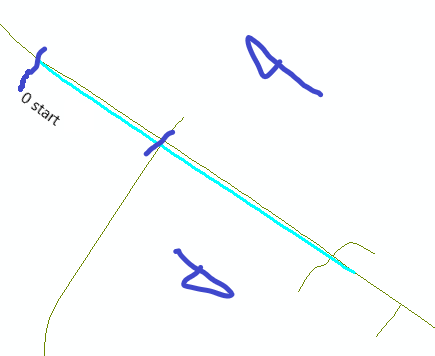
Sounds like your saying that if a known distance from an intersection, you want the routes zero point to start there and would it also stay that same distance if the intersection point moved or keep the same x,y? (colin.png)
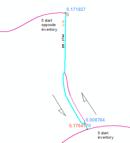
For us, if we have to represent the other side as shown above we would create the whole route starting at the end of the other route and ending at the beginning of the other route. (NC_divided_route.png)
- Mark as New
- Bookmark
- Subscribe
- Mute
- Subscribe to RSS Feed
- Permalink
Not quite. Because we only have a couple divided sections and they are very short, we are most interested in matching the measure of B1 to the A1 upchain route. NC's example makes a lot of sense, but measures calculated that way would have no practical meaning for us and would be a lot to manage for this tiny use case.
The idea would be to have B1's start calibration point, calibrate to the measure of A1 at the intersecting point.

Like I said I'm pretty sure this is not supported, just hoping someone can confirm.
- Mark as New
- Bookmark
- Subscribe
- Mute
- Subscribe to RSS Feed
- Permalink
Hello Colin
I've been following this thread and would like to provide some additional context. I understand you have main traversals (sometimes called trunk or inventory lines) which act conceptually as a measuring stick for certain other associated routes (in your case the partially divided opposite side routes) where you wish to derive the start measure as the measure of the main line where the two routes intersect. I'm assuming you then want to impart the end measure as the start measure plus the geometric length for the associated routes' centerlines.
We do have various rail and surface transportation customers who manage their calibration method in this way. I want to emphasize that Roads and Highways does support custom calibration and non-zero starting calibration for routes. However, the software does not specifically have configurable rules to apply calibration edits when the main line is edited. At time zero implementation, you absolutely could set up your LRS network with this type of custom calibration but then it would be up to the operational users to edit the calibration points of every intersecting associated route affected by any main line edit activity.
In ArcGIS Pro, you could minimize the amount of downstream derivative route calibration edits you need to complete by introducing a line network model which could act more like a control section LRM. Additionally, assuming you modeled some type of flag to deterministically associate non-mainline routes to a parent route you could also programmatically apply calibration update edits to those routes in ArcGIS Pro. For details on this capability (calibration point editing) please refer to the Enterprise Location Referencing (ArcGIS Pro) API: https://developers.arcgis.com/rest/services-reference/enterprise/apply-edits.htm
-amit@esri
- Mark as New
- Bookmark
- Subscribe
- Mute
- Subscribe to RSS Feed
- Permalink
We modeled the same direction in a previous system. I think you are correct that is not supported in any version. A workaround is to coroute the routes with the same beginning and ending points, that way any changes before the split both routes measures are updated with the same value.