- Home
- :
- All Communities
- :
- Industries
- :
- Natural Resources
- :
- Renewable Energy
- :
- Renewable Energy Questions
- :
- Calculating statistical correlation between featur...
- Subscribe to RSS Feed
- Mark Topic as New
- Mark Topic as Read
- Float this Topic for Current User
- Bookmark
- Subscribe
- Mute
- Printer Friendly Page
Calculating statistical correlation between features and upstream or downstream position on a river
- Mark as New
- Bookmark
- Subscribe
- Mute
- Subscribe to RSS Feed
- Permalink
Hello and thanks for not getting deterred by the aweful title - it's difficult to put the issue in one sentence.
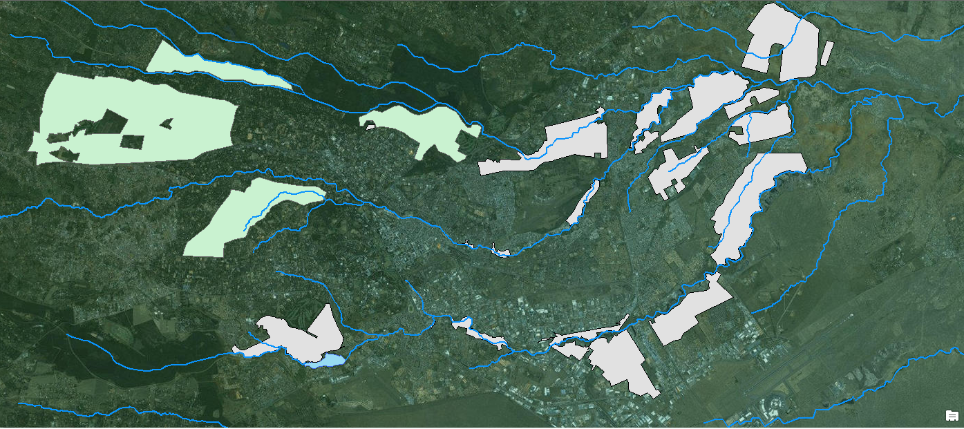
So this is what I want to do: I am working on aproject about the interaction of people and urban rivers in Nairobi. I want to show on a map how wealthy areas tend to be located upstream of the river, where they are still clean, while most slums are located downstream - and I want to have statistical proof for the correlation. I have traced the rivers (polylines), slums and wealthy areas (polygons). Now, is there any statistical analysis tool, which I can use to calculate a correlation between the "age" of the river (i.e. how many meters it has "spend" in the city area of Nairobi?
To make it easier to understand, here is a picture of the map so far. Green are welathy areas; gray are informal settlements; the rivers flow from West to East.

If this is not possible I would let the map speak for itself, I think I can make the point without statistical analysis, but it would be really neat "proof" it.
Any suggestions?
Thank you very much!
/Theo
Solved! Go to Solution.
- Mark as New
- Bookmark
- Subscribe
- Mute
- Subscribe to RSS Feed
- Permalink
We know that turbulent waters contain more dissolved oxygen (DO). Higher DO correlates to a greater ability of a river to purify itself.and is more beneficial for aquatic life. DO affects other water quality indicators such as clarity, taste and odor. We might ask where these varied residents obtain their drinking water from. Higher DO gives water a better taste than it would have otherwise, for example. DO is one water quality parameter which may assist your study. You might need to show whether the water quality (which can change --for better or worse --depending on one's location on a riverway) is in fact, better upstream. This is not always the case as already stated above.
The wealthy can most times avoid floods by locating upstream.
The residence times of rivers is short compared to glacerier and lakes, for examples. To reiterate, you might have to show how the water quality changes as the river water water flows downstream
Good Luck
- « Previous
-
- 1
- 2
- Next »
- « Previous
-
- 1
- 2
- Next »