- Home
- :
- All Communities
- :
- Developers
- :
- Native Maps SDKs
- :
- Qt Maps SDK Questions
- :
- fade map outside polygon geometry
- Subscribe to RSS Feed
- Mark Topic as New
- Mark Topic as Read
- Float this Topic for Current User
- Bookmark
- Subscribe
- Mute
- Printer Friendly Page
- Mark as New
- Bookmark
- Subscribe
- Mute
- Subscribe to RSS Feed
- Permalink
Hi i want fade my map outside its geometry like i have done javascript api like in the link.
Query : How to create the gray area over the extent expand to 10 so that i will perform difference between geometry and the extent
I want to do it same in qt sdkFade back map outside of polygon
Solved! Go to Solution.
Accepted Solutions
- Mark as New
- Bookmark
- Subscribe
- Mute
- Subscribe to RSS Feed
- Permalink
An simple solution might be to just buffer the geometry by whatever distance you want. https://developers.arcgis.com/qt/latest/qml/api-reference/qml-esri-arcgisruntime-geometryengine.html...
- Mark as New
- Bookmark
- Subscribe
- Mute
- Subscribe to RSS Feed
- Permalink
Hi guys can anyone help me in this task, as it is quite intricate for me to plot gray area outside polygons and then get difference of them
- Mark as New
- Bookmark
- Subscribe
- Mute
- Subscribe to RSS Feed
- Permalink
You can accomplish this by adding a Polygon graphic that has a hole in it.
Here is an example where I have a multipart polygon - one part has 4 points and the other has 4 as well. The interior part goes in counter clockwise order and is shown as a hole. This is described in the REST specs a bit for ArcGIS as a whole - Geometry objects—Common Data Types | ArcGIS for Developers
MapView {
id: mv
anchors.fill: parent
Map {
BasemapImagery{}
}
GraphicsOverlay {
Graphic {
symbol: SimpleFillSymbol {
color: Qt.rgba(0,0,0,.75);
}
geometry: Polygon {
json: {"rings":[[[-18684976.52965096,13174661.735383898],[11421379.755389877,11822129.922245625],[13775786.985667616,-9517816.462824922],[-18384413.904509123,-8215378.42054362],[-18684976.52965096,13174661.735383898]],[[-1202250.5005673468,3907314.1268438715],[601125.2502836883,4057595.4394147918],[651219.0211406611,5860971.190265823],[-1603000.667423129,5760783.648551878],[-1202250.5005673468,3907314.1268438715]]],"spatialReference":{"latestWkid":3857,"wkid":102100}}
}
}
}
}To keep this code concise, I just defined it in JSON, but you could use the PolygonBuilder class and add several parts to it. Each part should contain points. The order defined will be important for making it topologically sound and display as you desire
- Mark as New
- Bookmark
- Subscribe
- Mute
- Subscribe to RSS Feed
- Permalink
I am trying it this way and is succeed also and
want to expand graphics of overlayGray to some more km distance from my extent, can u help me how to expand it:my extent
Here in getExtentEnvelope() i counted the xmin xmax etc values manually, so the polygon appears on my whole screen. The pictures i attached below are some zoomed out images.
Component.onCompleted: {var overlaygeometry='';// add the polygonvar rings = userMap.getpolygon;//boundaries from dbgraphicsOverlay.graphics.append(createGraphic(createPolygon(rings), fillSymbol));overlaygeometry=GeometryEngine.difference(getExtentEnvelope(), createPolygon(rings));graphicsOverlay.graphics.append(createGraphic(overlaygeometry, overlayGray));}//End components.loaded
SimpleFillSymbol{
id:overlayGray
style: Enums.SimpleFillSymbolStyleSolid
color: Qt.rgba(1,1,0,0.2)
}function getExtentEnvelope(){const sr = ArcGISRuntimeEnvironment.createObject("SpatialReference", { "wkid": 4326});return ArcGISRuntimeEnvironment.createObject("Envelope", { xMin: xMinVal, yMin: yMinVal, xMax: xMaxVal, yMax: yMaxVal, spatialReference:sr});}function createGraphic(geometry, symbol) {var graphic = ArcGISRuntimeEnvironment.createObject("Graphic");graphic.geometry = geometry;graphic.symbol = symbol;return graphic;}//end createGraphicfunction createPolygon(ring) {// create polygon using jsonconst sr = { "wkid": 4326};var boundaryJson = {"rings":ring,"spatialReference":sr};var boundary= ArcGISRuntimeEnvironment.createObject("Polygon", {"json": boundaryJson});return boundary;}
- Mark as New
- Bookmark
- Subscribe
- Mute
- Subscribe to RSS Feed
- Permalink
Lucas Danzinger Is this task still on your list, i just want help with extent expamsion to some few kms, Can u. help me for it.
- Mark as New
- Bookmark
- Subscribe
- Mute
- Subscribe to RSS Feed
- Permalink
No, I don't understand what you are trying to accomplish.
- Mark as New
- Bookmark
- Subscribe
- Mute
- Subscribe to RSS Feed
- Permalink
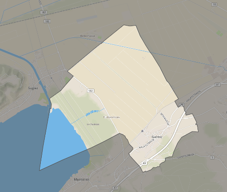
Hi I am trying to accomplish like this picture first make difference of 2 geometries then expand the extent of gray color to few kms
I have made geometry difference but does not know how to expand the gray color extent
function getExtentEnvelope(){const sr = ArcGISRuntimeEnvironment.createObject("SpatialReference", { "wkid": 4326});return ArcGISRuntimeEnvironment.createObject("Envelope", { xMin: xMinVal, yMin: yMinVal, xMax: xMaxVal, yMax: yMaxVal, spatialReference:sr});} with this the code gray color shows only to its extent limits. WHole code is in previous conversation of this thread

- Mark as New
- Bookmark
- Subscribe
- Mute
- Subscribe to RSS Feed
- Permalink
An simple solution might be to just buffer the geometry by whatever distance you want. https://developers.arcgis.com/qt/latest/qml/api-reference/qml-esri-arcgisruntime-geometryengine.html...
- Mark as New
- Bookmark
- Subscribe
- Mute
- Subscribe to RSS Feed
- Permalink
Thanks thats what i was looking for