- Home
- :
- All Communities
- :
- Developers
- :
- Native Maps SDKs
- :
- Qt Maps SDK Questions
- :
- Re: Creating Polyline Feature
- Subscribe to RSS Feed
- Mark Topic as New
- Mark Topic as Read
- Float this Topic for Current User
- Bookmark
- Subscribe
- Mute
- Printer Friendly Page
- Mark as New
- Bookmark
- Subscribe
- Mute
- Subscribe to RSS Feed
- Permalink
I drawed polyline in my application but I can't create a new one in line layer.
Here is my code beolow:
Here is my consol output below:
Thanks.
Solved! Go to Solution.
Accepted Solutions
- Mark as New
- Bookmark
- Subscribe
- Mute
- Subscribe to RSS Feed
- Permalink
Problem solved when I set symbolid value,line appeared on map.Because symbolid value was null.
var feature = ArcGISRuntime.createObject("Feature");
feature.geometry = userPolyline;
feature.setAttributeValue("symbolid",'19');
offLineLayer.featureTable.addFeature(feature);
Thanks Lucas .
- Mark as New
- Bookmark
- Subscribe
- Mute
- Subscribe to RSS Feed
- Permalink
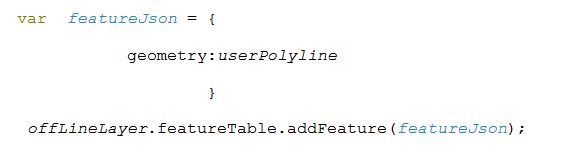
I suggest you try something like the following:
var feature = ArcGISRuntime.createObject("Feature");
feature.geometry = userPolyline;
offlineLayer.featureTable.addFeature(feature);
- Mark as New
- Bookmark
- Subscribe
- Mute
- Subscribe to RSS Feed
- Permalink
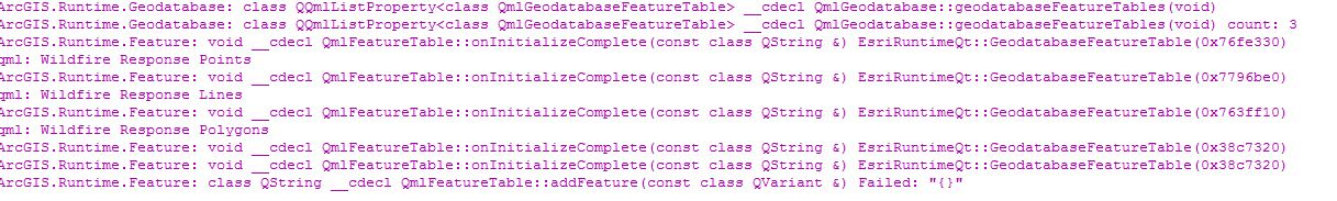
I changed my code like your code but polyline cannot created.Below is console output :
![]()
Thanks.
- Mark as New
- Bookmark
- Subscribe
- Mute
- Subscribe to RSS Feed
- Permalink
KK-
Can you please post your project, or a snippet that reproduces the issue?
Thanks,
Luke
- Mark as New
- Bookmark
- Subscribe
- Mute
- Subscribe to RSS Feed
- Permalink
Hi,
Here is the project below:
// Copyright 2015 ESRI
//
// All rights reserved under the copyright laws of the United States
// and applicable international laws, treaties, and conventions.
//
// You may freely redistribute and use this sample code, with or
// without modification, provided you include the original copyright
// notice and use restrictions.
//
// See the Sample code usage restrictions document for further information.
//
import QtQuick 2.0
import QtQuick.Dialogs 1.2
import QtQuick.Layouts 1.1
import QtQuick.Window 2.0
import ArcGIS.Runtime.Toolkit.Dialogs 1.0
import ArcGIS.Runtime.Toolkit.Controls 1.0
import QtQuick 2.3
import QtQuick.Controls 1.2
import QtQuick.Controls.Styles 1.2
import ArcGIS.Extras 1.0
import ArcGIS.Runtime 10.25
ApplicationWindow {
id: appWindow
width: 800
height: 600
title: "OfflinePolygonEditing"
property double scaleFactor: System.displayScaleFactor
property bool firstPoint: true
property bool firstLinePoint: true
property bool createPoint: false
property bool isDone: false
property int polyGraphicId
property int lineGraphicId
property int fontSize: 15 * scaleFactor
property bool isOnline: true
property string featuresUrl: "http://sampleserver6.arcgisonline.com/arcgis/rest/services/Sync/WildfireSync/FeatureServer"
property string gdbPath: "~/ArcGIS/Runtime/Data/Test/offlineSample.geodatabase"
property var selectedFeatureId: null
property var xProp: null
property var yProp: null
Envelope
{
id: sfExtent
xMin: 1930934.6938406308 //turkey
yMin: 3850498.260784086
xMax: 5912392.6567565575
yMax: 5564737.105928443
spatialReference: mainMap.spatialReference
}
Map {
id: mainMap
anchors.fill: parent
extent: sfExtent
focus: true
ArcGISTiledMapServiceLayer {
url: "http://services.arcgisonline.com/ArcGIS/rest/services/Canvas/World_Light_Gray_Base/MapServer"
}
FeatureLayer
{
id: offLineLayer
featureTable: appWindow.isOnline ? featureServiceTable : local
selectionColor: "cyan"
}
GraphicsLayer {
id: graphicsLayer
}
onStatusChanged: {
if (status === Enums.MapStatusReady) {
}
}
onMouseClicked: {
if (isDone)
{
return;
}
if(createPoint)
{
addLinePoint(mouse.mapPoint);
}
else
{
addPoint(mouse.mapPoint);
}
}
}
//END MAP
GeodatabaseFeatureTable {
id: local
geodatabase: gdb.valid ? gdb : null
featureServiceLayerId: 0
}
GeodatabaseFeatureServiceTable {
id: featureServiceTable
url: featuresUrl + "/1"
}
ServiceInfoTask {
id: serviceInfoTask
url: featuresUrl
onFeatureServiceInfoStatusChanged:{
if (featureServiceInfoStatus === Enums.FeatureServiceInfoStatusCompleted)
{
statusText.text = "Servis bilgisi alındı.Çalışma Alanı çizimini yapın";
}
else if (featureServiceInfoStatus === Enums.FeatureServiceInfoStatusErrored) {
statusText.text = "Error:";
generateButton.enabled = false;
cancelButton.text = "Start Over";
}
}
}
Feature {
id: featureToEdit
}
Rectangle {
anchors {
fill: controlsColumn
margins: -10 * scaleFactor
}
color: "lightgrey"
radius: 5 * scaleFactor
border.color: "black"
opacity: 0.77
MouseArea {
anchors.fill: parent
onClicked: (mouse.accepted = true)
}
}
Column {
id: controlsColumn
anchors {
left: parent.left
top: parent.top
margins: 20 * scaleFactor
}
spacing: 7
Row {
id: row
spacing: 10 * scaleFactor
}
Button {
id:silButton
text: "Çalışma Alanı Sil"
enabled: false
width: generateButton.width
style: ButtonStyle {
label: Text {
text: control.text
color: control.enabled ? "black" : "grey"
horizontalAlignment: Text.AlignHCenter
}
}
onClicked: {
if (userPolygon.pathCount > 0)
userPolygon.removePath(0);
isDone = false;
firstPoint = true;
graphicsLayer.removeAllGraphics();
generateButton.enabled=false;
}
}
Button {
id: generateButton
text: "Geodatabase Oluştur"
enabled: false
style: ButtonStyle {
label: Text {
text: control.text
color: control.enabled ? "black" : "grey"
horizontalAlignment: Text.AlignHCenter
}
}
onClicked: {
generateGeodatabaseParameters.initialize(serviceInfoTask.featureServiceInfo);
generateGeodatabaseParameters.extent = userPolygon;
generateGeodatabaseParameters.returnAttachments = false;
statusText.text = "Starting generate geodatabase task";
geodatabaseSyncTask.generateGeodatabase(generateGeodatabaseParameters, gdbPath);
}
}
Button {
id: syncButton
text: "Sync"
width: generateButton.width
enabled: false
style: generateButton.style
onClicked: {
enabled = false;
geodatabaseSyncTask.syncGeodatabase(gdb.syncGeodatabaseParameters, gdb);
statusText.text = "Starting sync task";
}
}
Button {
id: cancelButton
text: "İptal"
width: generateButton.width
enabled: false
style: generateButton.style
onClicked: {
geodatabaseSyncTask.cancelJob(syncStatusInfo);
enabled = false;
text = "İptal";
}
}
Row {
id: toggleOnlineOffline
spacing: 10
Text {
id: onlineStatus
text: appWindow.isOnline ? " Online " : " Offline "
color: "black"
}
Switch {
id: switchToggle
checked: appWindow.isOnline
enabled: false
onCheckedChanged: {
appWindow.isOnline = checked;
if (checked === true && Enums.GenerateStatusCompleted)
statusText.text = "Switch to Offline Mode to continue editing.";
else if (checked === false && Enums.GenerateStatusCompleted)
statusText.text = "Select a feature.";
}
}
}
}
Geodatabase {
id: gdb
path: geodatabaseSyncTask.geodatabasePath
onValidChanged: {
if (valid) {
var gdbtables = gdb.geodatabaseFeatureTables;
for(var i in gdbtables) {
console.log (gdbtables.featureServiceLayerName);
}
}
}
}
GeodatabaseSyncStatusInfo {
id: syncStatusInfo
}
GeodatabaseSyncTask {
id: geodatabaseSyncTask
url: featuresUrl
onGenerateStatusChanged: {
if (generateStatus === Enums.GenerateStatusCompleted)
{
statusText.text = geodatabasePath;
cancelButton.enabled = false;
generateButton.enabled = false;
appWindow.isOnline = false;
statusText.text = "Feature Oluştur";
createPoint= true;
}
else if (generateStatus === GeodatabaseSyncTask.GenerateError)
{
statusText.text = "Error: " + generateGeodatabaseError.message + " Code= " + generateGeodatabaseError.code.toString() + " " + generateGeodatabaseError.details;
generateButton.enabled = false;
cancelButton.text = "Start Over";
}
}
onGeodatabaseSyncStatusInfoChanged: {
if (geodatabaseSyncStatusInfo.status === Enums.GeodatabaseStatusUploadingDelta) {
var deltaProgress = geodatabaseSyncStatusInfo.deltaUploadProgress/1000;
var deltaSize = geodatabaseSyncStatusInfo.deltaSize/1000;
statusText.text = geodatabaseSyncStatusInfo.statusString + " " + String(deltaProgress) + " of " + String(deltaSize) + " KBs...";
} else
statusText.text = geodatabaseSyncStatusInfo.statusString + "...";
if (geodatabaseSyncStatusInfo.status !== GeodatabaseSyncStatusInfo.Cancelled)
cancelButton.enabled = true;
syncStatusInfo.json = geodatabaseSyncStatusInfo.json;
}
onSyncStatusChanged: {
featureServiceTable.refreshFeatures();
if (syncStatus === Enums.SyncStatusCompleted) {
cancelButton.enabled = false;
syncButton.enabled = false;
statusText.text = "Sync tamamlandı.Feature editlemeye devam edebilirsin.";
switchToggle.enabled = true;
}
if (syncStatus === Enums.SyncStatusErrored)
statusText.text = "Error: " + syncGeodatabaseError.message + " Code= " + syncGeodatabaseError.code.toString() + " " + syncGeodatabaseError.details;
}
}
GenerateGeodatabaseParameters {
id: generateGeodatabaseParameters
}
Rectangle {
id: textStatusRectangle
anchors {
fill: statusText
margins: -10 * scaleFactor
}
visible: statusText.text.length > 0
color: "lightgrey"
radius: 5
border.color: "black"
opacity: 0.77
}
Text {
id: statusText
anchors {
left: parent.left
right: parent.right
bottom: parent.bottom
margins: 20 * scaleFactor
}
wrapMode: Text.WordWrap
color: "black"
}
Component.onCompleted:
{
statusText.text = "Getting service info";
serviceInfoTask.fetchFeatureServiceInfo();
}
Polygon {
id: userPolygon
spatialReference: mainMap.spatialReference
}
Polyline {
id: userPolyline
spatialReference: mainMap.spatialReference
}
Graphic {
id: redPointGraphic
symbol: SimpleMarkerSymbol {
color: "red"
style: Enums.SimpleMarkerSymbolStyleCircle
size: 5
}
}
Graphic {
id: polygonGraphic
symbol: SimpleFillSymbol {
color: Qt.rgba(0.5, 0, 0.0, 0.25)
outline: SimpleLineSymbol {
color: "red"
style: Enums.SimpleLineSymbolStyleSolid
width: 2
}
}
}
Graphic {
id: blueLineGraphic
symbol: SimpleLineSymbol {
color: "blue"
style: Enums.SimpleLineSymbolStyleSolid
width: 5
}
}
Graphic {
id: bluePointGraphic
symbol: SimpleMarkerSymbol {
color: "blue"
style: Enums.SimpleMarkerSymbolStyleCircle
size: 5
}
}
function addPoint(mapPoint) {
var newPoint = redPointGraphic.clone();
newPoint.geometry = mapPoint;
graphicsLayer.addGraphic(newPoint);
var graphicClone = polygonGraphic.clone();
if (firstPoint) {
firstPoint = false;
userPolygon.startPath(mapPoint.x, mapPoint.y);
graphicClone.geometry = userPolygon;
polyGraphicId = graphicsLayer.addGraphic(graphicClone);
} else {
userPolygon.lineTo(mapPoint.x, mapPoint.y);
graphicClone.geometry = userPolygon;
graphicsLayer.updateGraphic(polyGraphicId, graphicClone);
if (userPolygon.pointCount > 2)
{
silButton.enabled = true
generateButton.enabled = true;//tener ekledi
statusText.text = "Geodatabase Oluştur Buttonuna basın";//eski
}
}
}
function addLinePoint(mapPoint)
{
var newPoint = bluePointGraphic.clone();
newPoint.geometry = mapPoint;
var graphicClone;
graphicsLayer.addGraphic(newPoint);
graphicClone = blueLineGraphic.clone();
if (firstLinePoint) {
firstLinePoint = false;
userPolyline.startPath(mapPoint.x, mapPoint.y);
graphicClone.geometry = userPolyline;
lineGraphicId = graphicsLayer.addGraphic(graphicClone);
} else {
userPolyline.lineTo(mapPoint.x, mapPoint.y);
graphicClone.geometry = userPolyline;
graphicsLayer.updateGraphic(lineGraphicId, graphicClone);
loadLayerColumn.visible = true;
}
}
Rectangle {
anchors.fill: parent
color: "transparent"
border {
width: 0.5 * scaleFactor
color: "black"
}
}
Rectangle {
color: "lightgrey"
radius: 5
border.color: "black"
opacity: 0.77
visible: loadLayerColumn.visible
anchors {
fill: loadLayerColumn
margins: -10 * scaleFactor
}
}
ColumnLayout {
id: loadLayerColumn
anchors {
left: parent.left
bottom: parent.bottom
right: parent.right
margins: 20 * scaleFactor
}
spacing: 10
visible: false
Text {
text: "Descrption özellik değerini gir"
}
TextField {
id: featureTextField
Layout.fillWidth: true
visible:true
text: "Özellik Değeri"
}
Row {
spacing: 10
Button {
id: okButton
text: "Ok"
onClicked: {
messageDialog.text = "";
loadLayerColumn.visible = false;
var feature = ArcGISRuntime.createObject("Feature");
feature.geometry = userPolyline;
offLineLayer.featureTable.addFeature(feature);
syncButton.enabled = true;
statusText.text = "Feature Servise düzenlemeleri kaydetme için Sync butonuna bas";
}
MessageDialog
{
id: messageDialog
title: "Error"
icon: StandardIcon.Warning
modality: Qt.WindowModal
standardButtons: StandardButton.Ok
}
}
Button {
text: "İptal"
onClicked: loadLayerColumn.visible = false
}
}
}
}
- Mark as New
- Bookmark
- Subscribe
- Mute
- Subscribe to RSS Feed
- Permalink
I didn't debug the whole thing, but I think the reason you are getting this failure debug message is because your feature table is for layer id "0" in the feature service, which is a point, and you are trying to add in a polyline to that feature table. It doesn't match the correct geometry, so it is rejecting the addFeature() call. I recommend switching the GeodatabaseFeatureTable and the GeodatabaseFeatureServiceTable both be 1.
-Luke
- Mark as New
- Bookmark
- Subscribe
- Mute
- Subscribe to RSS Feed
- Permalink
I updated the GeodatabaseFeatureTable and the GeodatabaseFeatureServiceTable both to 1, but can't create polyline.
Thanks.
- Mark as New
- Bookmark
- Subscribe
- Mute
- Subscribe to RSS Feed
- Permalink
Problem solved when I set symbolid value,line appeared on map.Because symbolid value was null.
var feature = ArcGISRuntime.createObject("Feature");
feature.geometry = userPolyline;
feature.setAttributeValue("symbolid",'19');
offLineLayer.featureTable.addFeature(feature);
Thanks Lucas .