- Home
- :
- All Communities
- :
- Developers
- :
- Python
- :
- Python Questions
- :
- Re: Volume Calculation using Cut/Fill Lowest Point...
- Subscribe to RSS Feed
- Mark Topic as New
- Mark Topic as Read
- Float this Topic for Current User
- Bookmark
- Subscribe
- Mute
- Printer Friendly Page
Volume Calculation using Cut/Fill Lowest Point base plane
- Mark as New
- Bookmark
- Subscribe
- Mute
- Subscribe to RSS Feed
- Permalink
Hi every one,
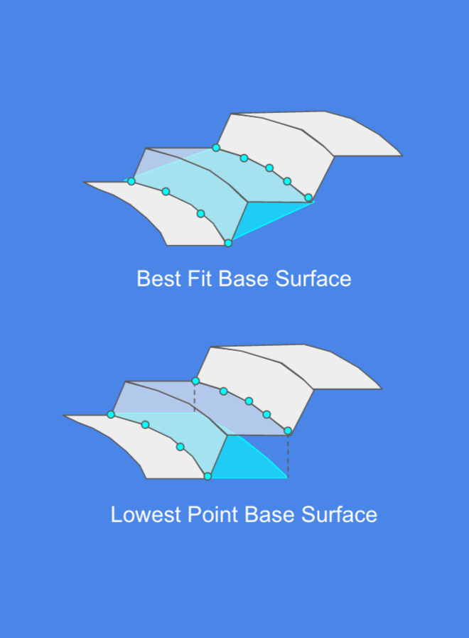
I'm writing a python script to calculate the volume of a polygon on raster using Cut/Fill tool and i see in some online service (for ex: DroneDeploy.com ...) for volume calculation there are 2 type of base plane: Best fit and lowest point:
Currently, i script seem to produce the result as same as DroneDeploy.com with their Best Fit base plane.
I want to writing another script to calculate volume with Lowest Point but don't know where to start with. You guys have any ideas about this problem?
Thanh you very much
- Mark as New
- Bookmark
- Subscribe
- Mute
- Subscribe to RSS Feed
- Permalink
are you looking for how to extend the base polyline parallel in the x,y direction and drop the z values of the upper polyline down to intersect with that plane? could be emulated with a 2d buffer of the lower step and a 3D intersect with the upper polyline. That would give you the back wall plane from which you could then determine the volume assuming you have the front and side planes
- Mark as New
- Bookmark
- Subscribe
- Mute
- Subscribe to RSS Feed
- Permalink
sorry sir, but can you show me some pseudo-code or something like that to achieve with arcpy because i don't understand your answer
- Mark as New
- Bookmark
- Subscribe
- Mute
- Subscribe to RSS Feed
- Permalink
Have you looked at the surface volume tool?
- Mark as New
- Bookmark
- Subscribe
- Mute
- Subscribe to RSS Feed
- Permalink
Thank you very much, but it's not what i want right now, i stuck with how to achieve the lowest point base plane.