- Home
- :
- All Communities
- :
- Developers
- :
- Python
- :
- Python Questions
- :
- Re: Updating Shape Field from Lat/Long Fields
- Subscribe to RSS Feed
- Mark Topic as New
- Mark Topic as Read
- Float this Topic for Current User
- Bookmark
- Subscribe
- Mute
- Printer Friendly Page
- Mark as New
- Bookmark
- Subscribe
- Mute
- Subscribe to RSS Feed
- Permalink
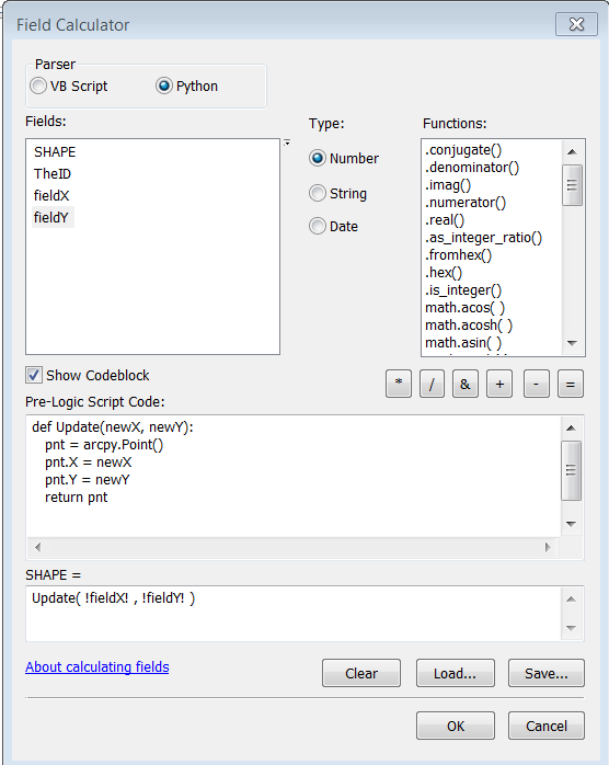
I'm trying to update the SHAPE field of some points by using field calculator to update the SHAPE field based on X, Y fields in the attribute table. Can this be done? I'm trying the below calculation, and the points are changing location, but not to a location that is near either the X, Y fields I'm asking it to. I'm not sure where I'm going wrong here.
Solved! Go to Solution.
Accepted Solutions
- Mark as New
- Bookmark
- Subscribe
- Mute
- Subscribe to RSS Feed
- Permalink
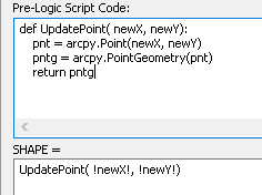
The actual reason why the calculation wasn't working is since you return a Point object when the geometry is in fact a PointGeometry.object. See the field calculator expression below:
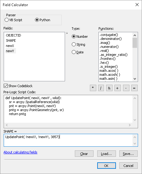
So you create a point object with the new X and Y and then use the point object to create the point geometry.. What you did in your second example is providing the point geometry to the function and modify the point X and Y properties using the first part, and returning the point geometry object again
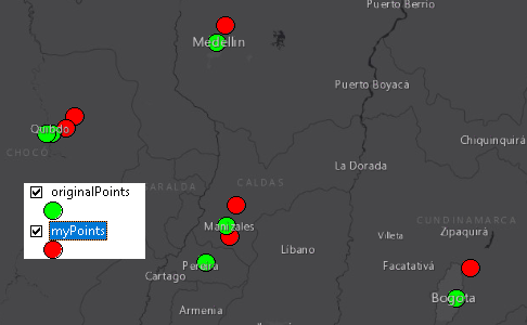
CC Jayanta Poddar , it is possible to modify the geometry using the field calculator as the result below shows. The red dots were moved with coordinates from my X and Y fields:
- Mark as New
- Bookmark
- Subscribe
- Mute
- Subscribe to RSS Feed
- Permalink
some sample values might help... if they are supposed to be in longitude and latitude, make sure longitude is the X and latitude is the Y (a common error) and in the western hemisphere, longitude is negative..
- Mark as New
- Bookmark
- Subscribe
- Mute
- Subscribe to RSS Feed
- Permalink
Dan,
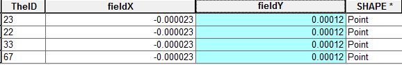
Here are my values I'm trying to put in the shape field.
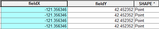
But after I run the calc, and then pull the values out of the shape field, they resemble nothing of the X, Y fields. It changes it to the following. I don't get it.
- Mark as New
- Bookmark
- Subscribe
- Mute
- Subscribe to RSS Feed
- Permalink
I would suggest adding the table to arcmap as an event layer then save/export it as a shapefile or featureclass in a geodatabase... there is no point messing with the shapefile since something is amiss. You will have all your attributes and the file will be clean. As shown the top field does have the correct X and Y values with Longitude in the -121 and lat at 42.
- Mark as New
- Bookmark
- Subscribe
- Mute
- Subscribe to RSS Feed
- Permalink
Shoot, I had the script wrong. I needed the Shape as a parameter. This works. Thanks Dan.
- Mark as New
- Bookmark
- Subscribe
- Mute
- Subscribe to RSS Feed
- Permalink
The actual reason why the calculation wasn't working is since you return a Point object when the geometry is in fact a PointGeometry.object. See the field calculator expression below:
So you create a point object with the new X and Y and then use the point object to create the point geometry.. What you did in your second example is providing the point geometry to the function and modify the point X and Y properties using the first part, and returning the point geometry object again
CC Jayanta Poddar , it is possible to modify the geometry using the field calculator as the result below shows. The red dots were moved with coordinates from my X and Y fields:
- Mark as New
- Bookmark
- Subscribe
- Mute
- Subscribe to RSS Feed
- Permalink
Rethinking it I realize that you don't have to specify the spatial reference, since the featureclass already has this defined. You could use this to make thing more simple:

- Mark as New
- Bookmark
- Subscribe
- Mute
- Subscribe to RSS Feed
- Permalink
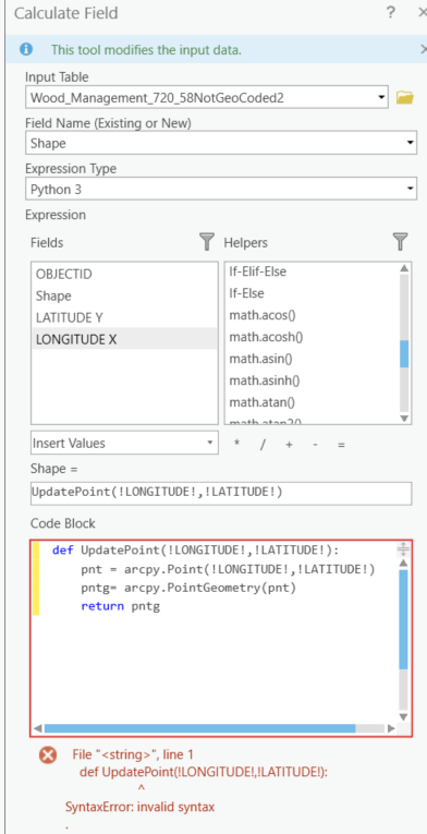
The function parameters in the code block should not have exclamation marks, that's only for the field names in the expression. Get rid of all ! characters in the code block.
- Mark as New
- Bookmark
- Subscribe
- Mute
- Subscribe to RSS Feed
- Permalink
In ArcGIS, Shape* is a system-managed field that is used to store the Geometry-type of the Features. It is Read-only, and you cannot edit it.
Think Location