- Home
- :
- All Communities
- :
- Developers
- :
- Python
- :
- Python Questions
- :
- Re: TypeError: value #1 - unsupported type: Polygo...
- Subscribe to RSS Feed
- Mark Topic as New
- Mark Topic as Read
- Float this Topic for Current User
- Bookmark
- Printer Friendly Page

- Mark as New
- Bookmark
- Subscribe to RSS Feed
- Permalink
Hey,
I'm trying to add new rows into empty polygon feature.
this is the code:
try:
cur = arcpy.da.InsertCursor(outshp, ["Id" , 'Floor_area'])
file = open(csvfile)
reader = csv.reader(file)
line = next(reader)
cnt = 0
for line in reader:
new_row = [line[0]]
points = []
for i in line[1:]:
p = i.split(',')
point = arcpy.Point(p[0], p[1])
points.append(point)
arr = arcpy.Array(points)
polygn = arcpy.Polygon(arr)
new_row.append(polygn)
cur.insertRow(new_row)
cnt += 1
del cur
except:
traceback.print_exc()
del cur
sadly, I'm getting this error:
Traceback (most recent call last):
  File "<ipython-input-8-44580ffd528c>", line 21, in <module>
    cur.insertRow(new_row)
TypeError: value #1 - unsupported type: Polygon
Solved! Go to Solution.
- Mark as New
- Bookmark
- Subscribe to RSS Feed
- Permalink
Thank to some of the advices here the error has been resolved, but the feature don't includes coordinates and doesn't appear on the map... i can't really understand why.
this is all of the code:
import csv
import arcpy
import traceback

#Create Polygon layer from csv table

csvfile = r'C:\Geography\Spatial Python\final\Final_Ex\Buildings_alternative_2.csv'
outpath = r'C:\geography\Spatial Python\final'
outshp =  'test.shp'

outshp = arcpy.CreateFeatureclass_management (
    outpath, outshp, geometry_type='POLYGON',
    spatial_reference=arcpy.SpatialReference(4326))

arcpy.AddField_management (outshp, 'Floor_area', "LONG")
arcpy.AddField_management (outshp, 'SHAPE@', "DOUBLE")

try:

    cur = arcpy.da.InsertCursor(outshp, ["Id" , 'Floor_area', 'SHAPE@'])
    file = open(csvfile)
    reader = csv.reader(file)
    line = next(reader)
    cnt = 1

    for line in reader:
        new_row = [cnt, line[0]]
        points = []


        for i in line[1:]:
            p = i.split(',')
            point = arcpy.Point(p[0], p[1])
            points.append(point)
        arr = arcpy.Array(points)
        polygon = arcpy.Polygon(arr)
        new_row.append(polygon)
        cur.insertRow(new_row)
        cnt += 1
    del cur


except:
    traceback.print_exc()
    del cur
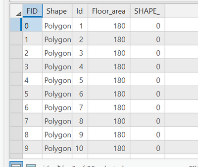
the table includes the 'floor area' field but not the spatial data.


- Mark as New
- Bookmark
- Subscribe to RSS Feed
- Permalink
Could you post some sample rows from the CSV?
- Mark as New
- Bookmark
- Subscribe to RSS Feed
- Permalink
- Mark as New
- Bookmark
- Subscribe to RSS Feed
- Permalink
It's hard to get the full picture of what's happening with this screenshot. It would help if you could post the raw text of a few rows (with header row).
From what I can see here, column A is your "Id" field? Is there a variable number of point coordinate columns? Also, I see you're creating a "SHAPE@" field in the shapefile. That's not how that's intended to work. It's what's called a field token. It's not a field name that actually exists.
InsertCursor—ArcMap | Documentation (arcgis.com)
Here's some updated code but I'm not certain it will solve your problem.
import csv
import arcpy
import traceback

#Create Polygon layer from csv table

csvfile = r'C:\Geography\Spatial Python\final\Final_Ex\Buildings_alternative_2.csv'
outpath = r'C:\geography\Spatial Python\final'
outshp =  'test.shp'

try:
    outshp = arcpy.CreateFeatureclass_management(
        outpath, outshp, geometry_type='POLYGON',
        spatial_reference=arcpy.SpatialReference(4326)
    )

    arcpy.AddField_management (outshp, 'Id', "TEXT")
    arcpy.AddField_management (outshp, 'Floor_area', "DOUBLE")

    with open(csvfile, "r") as csv_reader:
        with arcpy.da.InsertCursor(outshp, ["Id", "Floor_area", 'SHAPE@']) as cur:
            for csv_line in csv_reader:
                polygon_points = []
                for point in line[1:]:
                    x, y = point.split(",")
                    point_geometry = arcpy.Point(x, y)
                    polygon_points.append(point_geometry)
                polygon_geometry = arcpy.Polygon(arcpy.Array(polygon_points))
                polygon_geometry_sqft = polygon_geometry.getArea(units="SQUAREFEET")
                cur.insertRow((csv_line[0], polygon_geometry_sqft, polygon_geometry))
except:
    traceback.print_exc()
Try grabbing a single row of point coordinates from your CSV and hard coding them into your script (no CSV looping). Use those values to try inserting a single record into the shapefile. Start small to troubleshoot.
- Mark as New
- Bookmark
- Subscribe to RSS Feed
- Permalink
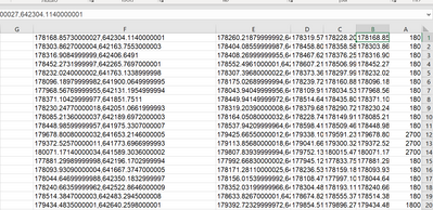
thease are the first 2 rows, the coloumns are from left to right:
| 180 | 178168.85730000027,642304.1140000001 | 178228.20880000014,642355.0789000001 | 178319.57019999996,642248.6835999992 | 178260.21879999992,642197.7185999993 | 178168.85730000027,642304.1140000001 |
| 180 | 178303.8627000004,642163.7553000003 | 178358.5828999998,642219.6634999998 | 178458.8058000002,642121.5704999994 | 178404.08559999987,642065.6622000001 | 178303.8627000004,642163.7553000003 |
Column A is Floor area and the rest are coodinates (x,y in every cell). the Id added automatically to the table, i'm not sure how but i can see that on arcGis pro. The variable for the id it "cnt".
there are varaibles for the coordinates and i'm looping on them here:
        for p in line[1:]: #looping the coordinates in every line
            pnt = p.split(',') #split x and y coordinates
            point = arcpy.Point(pnt[0], pnt[1]) #create a point feature
            points.append(point) #add to the point list
        arr = arcpy.Array(points)
        polygon = arcpy.Polygon(arr)
        new_row.append(polygon)
        cur.insertRow(new_row)
        cnt += 1
    del cur
I'm not familiar with the commands you wrote in the code, but the table i get is partial and i get this error:
  File "<ipython-input-26-e60a0c54162d>", line 17, in <module>
    arcpy.AddField_management (outshp, 'Id', "TEXT")
  File "C:\Program Files\ArcGIS\Pro\Resources\ArcPy\arcpy\management.py", line 4337, in AddField
    raise e
  File "C:\Program Files\ArcGIS\Pro\Resources\ArcPy\arcpy\management.py", line 4334, in AddField
    retval = convertArcObjectToPythonObject(gp.AddField_management(*gp_fixargs((in_table, field_name, field_type, field_precision, field_scale, field_length, field_alias, field_is_nullable, field_is_required, field_domain), True)))
  File "C:\Program Files\ArcGIS\Pro\Resources\ArcPy\arcpy\geoprocessing\_base.py", line 511, in <lambda>
    return lambda *args: val(*gp_fixargs(args, True))
arcgisscripting.ExecuteError: Failed to execute. Parameters are not valid.
ERROR 000012: Id already exists
Failed to execute (AddField).
- Mark as New
- Bookmark
- Subscribe to RSS Feed
- Permalink
Turns out that the problem was with the projection.
thanks for the help.
this is the code that works:
import csv
import arcpy
import traceback

#Create polygon feature from csv file

csvfile = r'C:\Geography\Spatial Python\final\Final_Ex\Buildings_alternative_2.csv'
outpath = r'C:\geography\Spatial Python\final'
outshp =  'build.shp'

outshp = arcpy.CreateFeatureclass_management (
    outpath, outshp, geometry_type='POLYGON',
    spatial_reference=arcpy.SpatialReference(2039))

arcpy.AddField_management (outshp, 'Floor_area', "LONG") #add field for Floor area

try:

    cur = arcpy.da.InsertCursor(outshp, ['Id', 'Floor_area', 'SHAPE@'])
    f = open(csvfile)
    reader = csv.reader(f)
    lne = next(reader)
    cnt = 1


    for line in reader: #looping lines in the csv file
        new_row = [cnt, line[0]] # index of the row and the floor area field
        points = []


        for p in line[1:]: #looping the coordinates in every line
            pnt = p.split(',') #split x and y coordinates
            point = arcpy.Point(float(pnt[0]), float(pnt[1])) #create a point feature
            points.append(point) #add to the point list
        arr = arcpy.Array(points)
        polygon = arcpy.Polygon(arr)
        new_row.append(polygon)
        cur.insertRow(new_row)
        cnt += 1

    del cur

- « Previous
-
- 1
- 2
- Next »
- « Previous
-
- 1
- 2
- Next »