- Home
- :
- All Communities
- :
- Developers
- :
- Python
- :
- Python Questions
- :
- Re: Shifting X coordinates using SHAPE@X
- Subscribe to RSS Feed
- Mark Topic as New
- Mark Topic as Read
- Float this Topic for Current User
- Bookmark
- Subscribe
- Mute
- Printer Friendly Page
- Mark as New
- Bookmark
- Subscribe
- Mute
- Subscribe to RSS Feed
- Permalink
Hi,
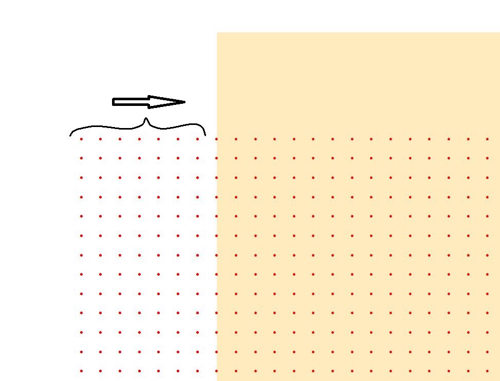
I need to shift by 360° points that are offset. It is just 7 columns of points in the West on the X axis that need to be shifted (see pictures and script below). I'm getting this error: TypeError: 'float' object has no attribute '__getitem__'
Also, I'm not sure if I'm selecting/identifying the 7 columns of points I want correctly on my script.
Any help will be much appreciated.

import arcpy
import string
import math
FC = r"H:\NETcdf_TEST\TEST.gdb\rast2point"
x_shift = float(360)
with arcpy.da.UpdateCursor(FC, ['SHAPE@X']) as cursor:
for row in cursor:
cursor.updateRow([[row[0][7] + x_shift]])
del cursor
Solved! Go to Solution.
Accepted Solutions
- Mark as New
- Bookmark
- Subscribe
- Mute
- Subscribe to RSS Feed
- Permalink
Thanks for all the suggestions. I did it selecting first the points I wanted to move. Maybe not very elegant but it works.
import arcpy
from arcpy import env
from arcpy.sa import *
FC1 = r"H:\NETcdf_TEST\TEST.gdb\rast2point" # This is the point FC after resampling (0.25/bilinear) and converting the shifted netcdf
FC2 = r"H:\NETcdf_TEST\TEST.gdb\rast2point2"
FC1new = r"H:\NETcdf_TEST\TEST.gdb\rast2point_new1"
FC2new = r"H:\NETcdf_TEST\TEST.gdb\rast2point2_new2"
FCfinal = r"H:\NETcdf_TEST\TEST.gdb\rast2pointFinal"
# Add XY coordinate fields and calculate field geometry
arcpy.AddXY_management(FC1)
# Make a copy of FC1
arcpy.Copy_management(FC1,FC2)
# Make layers from FCs
arcpy.MakeFeatureLayer_management(FC1, "FC1_lyr")
arcpy.MakeFeatureLayer_management(FC2, "FC2_lyr")
# Select point values <-180 (FC1) and point values >-180 (FC2)
arcpy.SelectLayerByAttribute_management("FC1_lyr", "NEW_SELECTION", '"POINT_X" <-180')
arcpy.SelectLayerByAttribute_management("FC2_lyr", "NEW_SELECTION", '"POINT_X" >-180')
# Write the selected features to a new featureclass
arcpy.CopyFeatures_management("FC1_lyr", FC1new)
arcpy.CopyFeatures_management("FC2_lyr", FC2new)
# Perform the move of FC1new
xOffset = 360.000
yOffset = 0.000
with arcpy.da.UpdateCursor(FC1new, ["SHAPE@XY"]) as cursor:
for row in cursor:
cursor.updateRow([[row[0][0] + xOffset,row[0][1] + yOffset]])
# Refresh GDB
arcpy.RefreshCatalog(r"H:\NETcdf_TEST\TEST.gdb")
# Merge FC1new and FC2new into FCfinal
arcpy.Merge_management([FC1new, FC2new], FCfinal)
- Mark as New
- Bookmark
- Subscribe
- Mute
- Subscribe to RSS Feed
- Permalink
try [:7] instead of [7]
- Mark as New
- Bookmark
- Subscribe
- Mute
- Subscribe to RSS Feed
- Permalink
Are you selecting first only the points you want to shift? If you have a feature class with lots of points and only want to shift some, you either have to understand how the points are ordered or only select those you want to shift; otherwise, you won't have any way to know whether a point needs to be shifted or not.
In your code above, row will be a list with a single X value, the X value of the "first" point, whatever that point is depending on the ordering of the cursor. Your code is failing because row[0] returned a float, and floats don't support indexing, slicing, or other similar functions that sequences support.
- Mark as New
- Bookmark
- Subscribe
- Mute
- Subscribe to RSS Feed
- Permalink
Your points look like a raster that has been converted to points.
Do you want to shift a raster? This can be done using the Shift tool in Desktop and Pro.
(Thought it was worth mentioning.)
- Mark as New
- Bookmark
- Subscribe
- Mute
- Subscribe to RSS Feed
- Permalink
Thanks for all the suggestions. I did it selecting first the points I wanted to move. Maybe not very elegant but it works.
import arcpy
from arcpy import env
from arcpy.sa import *
FC1 = r"H:\NETcdf_TEST\TEST.gdb\rast2point" # This is the point FC after resampling (0.25/bilinear) and converting the shifted netcdf
FC2 = r"H:\NETcdf_TEST\TEST.gdb\rast2point2"
FC1new = r"H:\NETcdf_TEST\TEST.gdb\rast2point_new1"
FC2new = r"H:\NETcdf_TEST\TEST.gdb\rast2point2_new2"
FCfinal = r"H:\NETcdf_TEST\TEST.gdb\rast2pointFinal"
# Add XY coordinate fields and calculate field geometry
arcpy.AddXY_management(FC1)
# Make a copy of FC1
arcpy.Copy_management(FC1,FC2)
# Make layers from FCs
arcpy.MakeFeatureLayer_management(FC1, "FC1_lyr")
arcpy.MakeFeatureLayer_management(FC2, "FC2_lyr")
# Select point values <-180 (FC1) and point values >-180 (FC2)
arcpy.SelectLayerByAttribute_management("FC1_lyr", "NEW_SELECTION", '"POINT_X" <-180')
arcpy.SelectLayerByAttribute_management("FC2_lyr", "NEW_SELECTION", '"POINT_X" >-180')
# Write the selected features to a new featureclass
arcpy.CopyFeatures_management("FC1_lyr", FC1new)
arcpy.CopyFeatures_management("FC2_lyr", FC2new)
# Perform the move of FC1new
xOffset = 360.000
yOffset = 0.000
with arcpy.da.UpdateCursor(FC1new, ["SHAPE@XY"]) as cursor:
for row in cursor:
cursor.updateRow([[row[0][0] + xOffset,row[0][1] + yOffset]])
# Refresh GDB
arcpy.RefreshCatalog(r"H:\NETcdf_TEST\TEST.gdb")
# Merge FC1new and FC2new into FCfinal
arcpy.Merge_management([FC1new, FC2new], FCfinal)