- Home
- :
- All Communities
- :
- Developers
- :
- Python
- :
- Python Questions
- :
- Re: Python script to find out if two layers are ov...
- Subscribe to RSS Feed
- Mark Topic as New
- Mark Topic as Read
- Float this Topic for Current User
- Bookmark
- Subscribe
- Mute
- Printer Friendly Page
Python script to find out if two layers are overlapping
- Mark as New
- Bookmark
- Subscribe
- Mute
- Subscribe to RSS Feed
- Permalink
As part of QAQC, I have to routinely check if all vector line data is buffered on the buffered layer. The layers are: vector line layer, buffer layer, and grid number layer. As of right now, I scan the entire county boundary to see if there is any vector line data that is not buffered on the buffer layer. If it is not buffered, I need to find out which grid number the problem resides.
I would like to make a python script that would check to see if all vector line data (layer 1) is overlaying the buffered layer (layer 2) and if not, which grid number (layer 3) is the problem.
Does anyone have any experience trying to write a python script that can tell if one layer is spatially overlaying another layer?
Code examples would be much appreciated.
- Mark as New
- Bookmark
- Subscribe
- Mute
- Subscribe to RSS Feed
- Permalink
I haven't done it specifically, but a spatial selection or a series of them ought to do the trick
- Mark as New
- Bookmark
- Subscribe
- Mute
- Subscribe to RSS Feed
- Permalink
Hi ggroshans_GreenvilleWater ,
Can you provide a screenshot showing the lines, buffers and grids or provide a sample of your data? There are a couple of things that might complicate this and I would like to see some specific situations to see what would be possible.
- Mark as New
- Bookmark
- Subscribe
- Mute
- Subscribe to RSS Feed
- Permalink
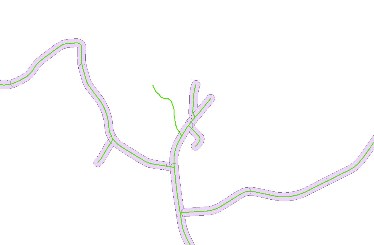
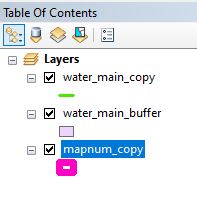
Hi Xander,
Thank you for your help. I have attached three screenshots. 1) A view of the vector line data, the buffer layer, and an example of how the vector line data may not correspond to the buffer layer, 2) A screenshot of my table of contents, and 3) A zoomed out view to show the grid layer (e.g., screenshot 1 is within grid 38).

- Mark as New
- Bookmark
- Subscribe
- Mute
- Subscribe to RSS Feed
- Permalink
What's the field name used in mapnum_copy for labelling?
- Mark as New
- Bookmark
- Subscribe
- Mute
- Subscribe to RSS Feed
- Permalink
Thanks for all your help so far. The field name used in mapnum_copy for labeling is called MapNum
- Mark as New
- Bookmark
- Subscribe
- Mute
- Subscribe to RSS Feed
- Permalink
import arcpy
arcpy.MakeFeatureLayer_management('water_main_copy', 'water_main_copy_lyr')
arcpy.SelectLayerByLocation_management('water_main_copy_lyr', "WITHIN", 'water_main_buffer')
arcpy.SelectLayerByLocation_management('water_main_copy', "", "", "", "SWITCH_SELECTION")
arcpy.SelectLayerByLocation_management('mapnum_copy', "INTERSECT", 'water_main_copy')
fc = 'mapnum_copy'
field = 'MapNum'
cursor = arcpy.SearchCursor(fc)
for row in cursor:
print(row.getValue(field))
This would be a way to make a feature layer. Give it a try and if it gives you errors just follow the similar naming convention for feature layers for water_main_buffer and mapnum_copy.
The text that comes will be the Map Numbers with unbuffered water mains.
Hope this helps!
- Mark as New
- Bookmark
- Subscribe
- Mute
- Subscribe to RSS Feed
- Permalink
Hi, I use a similar script from the Python window in ArcMap
##running from Python window in ArcMap with layers already MXD and using layer names as per your post
import arcpy
arcpy.SelectLayerByLocation_management('layer1', "WITHIN", 'layer2')
arcpy.SelectLayerByLocation_management('layer1', "", "", "", "SWITCH_SELECTION")
arcpy.SelectLayerByLocation_management('layer3', "INTERSECT", 'layer1')
fc = 'layer3'
field = 'layer3_field_that_contains_grid_name'
cursor = arcpy.SearchCursor(fc)
for row in cursor:
print(row.getValue(field))
- Mark as New
- Bookmark
- Subscribe
- Mute
- Subscribe to RSS Feed
- Permalink
What's the name of the labeling field in mapnum_copy?
- Mark as New
- Bookmark
- Subscribe
- Mute
- Subscribe to RSS Feed
- Permalink
Using the syntax highlighter makes code reading much easier:
##running from Python window in ArcMap with layers already MXD and using layer names as per your post
import arcpy
arcpy.SelectLayerByLocation_management('layer1', "WITHIN", 'layer2')
arcpy.SelectLayerByLocation_management('layer1', "", "", "", "SWITCH_SELECTION")
arcpy.SelectLayerByLocation_management('layer3', "INTERSECT", 'layer1')
fc = 'layer3'
field = 'layer3_field_that_contains_grid_name'
cursor = arcpy.SearchCursor(fc)
for row in cursor: