- Home
- :
- All Communities
- :
- Developers
- :
- Python
- :
- Python Questions
- :
- Re: Python- need help with a code
- Subscribe to RSS Feed
- Mark Topic as New
- Mark Topic as Read
- Float this Topic for Current User
- Bookmark
- Subscribe
- Mute
- Printer Friendly Page
Python- need help with a code
- Mark as New
- Bookmark
- Subscribe
- Mute
- Subscribe to RSS Feed
- Permalink
Hi all,
I am new at a company and I'm investigating a problem with a python script we have. The script basically extracts 1000s of rows of property data from a database (QL) and by using X Y data stored in this database, it creates a shapefile which we then use throughout the company.
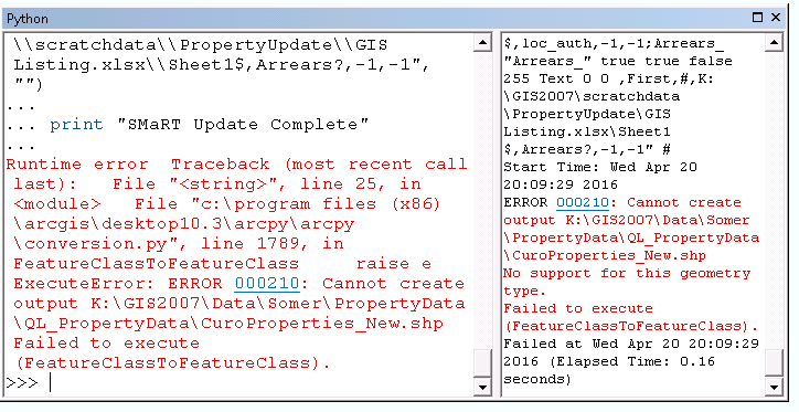
The script was authored by a python expert who doesn't work here anymore. The script worked fine for him, and all the software was on 10.0 at the time. After an upgrade to 10.3 and 10.4, the script doesn't work for us now and throws up an ERROR 000210: Cannot create output K:\ blah blah.. Failed to execute (FeatureClassToFeatureClass). As I'm not that experienced with python scripting and the author of the script isn't around to help, I thought I'd ask here.
Here is the original code that has returned an error, only after upgrading our software from 10.0.
# ---------------------------------------------------------------------------
# All_Curo_Properties.py
# Created on: 2013-03-19 09:26:01.00000
# (generated by ArcGIS/ModelBuilder)
# Description:
# ---------------------------------------------------------------------------
# Import arcpy module
import arcpy
# Overwrite pre-existing files
arcpy.geoprocessing.env.overwriteOutput = True
# Local variables:
Sheet1_ = "K:\\GIS2007\\scratchdata\\PropertyUpdate\\GIS Listing.xlsx\\Sheet1$"
QL_PropertyData = "K:\\GIS2007\\Data\\Somer\\PropertyData\\QL_PropertyData"
Sheet1___2_ = "K:\\GIS2007\\scratchdata\\PropertyUpdate\\GIS Listing.xlsx\\Sheet1$"
QL_PropertyData__2_ = "K:\\GIS2007\\Data\\Somer\\PropertyData\\QL_PropertyData"
Sheet1__Layer = "Sheet1$_Layer"
# Process: Make XY Event Layer
arcpy.MakeXYEventLayer_management(Sheet1___2_, "easting", "northing", Sheet1__Layer, "PROJCS['British_National_Grid',GEOGCS['GCS_OSGB_1936',DATUM['D_OSGB_1936',SPHEROID['Airy_1830',6377563.396,299.3249646]],PRIMEM['Greenwich',0.0],UNIT['Degree',0.0174532925199433]],PROJECTION['Transverse_Mercator'],PARAMETER['False_Easting',400000.0],PARAMETER['False_Northing',-100000.0],PARAMETER['Central_Meridian',-2.0],PARAMETER['Scale_Factor',0.9996012717],PARAMETER['Latitude_Of_Origin',49.0],UNIT['Meter',1.0]];-5220400 -15524400 10000;-100000 10000;-100000 10000;0.001;0.001;0.001;IsHighPrecision", "")
# Process: Feature Class to Feature Class
arcpy.FeatureClassToFeatureClass_conversion(Sheet1__Layer, QL_PropertyData__2_, "CuroProperties_All.shp", "", "prty_id \"prty_id\" true true false 255 Text 0 0 ,First,#,K:\\GIS2007\\scratchdata\\PropertyUpdate\\GIS Listing.xlsx\\Sheet1$,prty_id,-1,-1;alt_prty_i \"alt_prty_i\" true true false 255 Text 0 0 ,First,#,K:\\GIS2007\\scratchdata\\PropertyUpdate\\GIS Listing.xlsx\\Sheet1$,alt_prty_id,-1,-1;Title \"Title\" true true false 255 Text 0 0 ,First,#,K:\\GIS2007\\scratchdata\\PropertyUpdate\\GIS Listing.xlsx\\Sheet1$,Title,-1,-1;Forename \"Forename\" true true false 255 Text 0 0 ,First,#,K:\\GIS2007\\scratchdata\\PropertyUpdate\\GIS Listing.xlsx\\Sheet1$,Forename,-1,-1;Surname \"Surname\" true true false 255 Text 0 0 ,First,#,K:\\GIS2007\\scratchdata\\PropertyUpdate\\GIS Listing.xlsx\\Sheet1$,Surname,-1,-1;fmly_mems \"fmly_mems\" true true false 8 Double 6 15 ,First,#,K:\\GIS2007\\scratchdata\\PropertyUpdate\\GIS Listing.xlsx\\Sheet1$,fmly_mems,-1,-1;add_1 \"add_1\" true true false 255 Text 0 0 ,First,#,K:\\GIS2007\\scratchdata\\PropertyUpdate\\GIS Listing.xlsx\\Sheet1$,add_1,-1,-1;add_2 \"add_2\" true true false 255 Text 0 0 ,First,#,K:\\GIS2007\\scratchdata\\PropertyUpdate\\GIS Listing.xlsx\\Sheet1$,add_2,-1,-1;add_3 \"add_3\" true true false 255 Text 0 0 ,First,#,K:\\GIS2007\\scratchdata\\PropertyUpdate\\GIS Listing.xlsx\\Sheet1$,add_3,-1,-1;add_4 \"add_4\" true true false 255 Text 0 0 ,First,#,K:\\GIS2007\\scratchdata\\PropertyUpdate\\GIS Listing.xlsx\\Sheet1$,add_4,-1,-1;add_5 \"add_5\" true true false 255 Text 0 0 ,First,#,K:\\GIS2007\\scratchdata\\PropertyUpdate\\GIS Listing.xlsx\\Sheet1$,add_5,-1,-1;post_code \"post_code\" true true false 255 Text 0 0 ,First,#,K:\\GIS2007\\scratchdata\\PropertyUpdate\\GIS Listing.xlsx\\Sheet1$,post_code,-1,-1;fulladdr \"fulladdr\" true true false 255 Text 0 0 ,First,#,K:\\GIS2007\\scratchdata\\PropertyUpdate\\GIS Listing.xlsx\\Sheet1$,fulladdr,-1,-1;PropertyTy \"PropertyTy\" true true false 255 Text 0 0 ,First,#,K:\\GIS2007\\scratchdata\\PropertyUpdate\\GIS Listing.xlsx\\Sheet1$,PropertyType,-1,-1;sh_size_de \"sh_size_de\" true true false 255 Text 0 0 ,First,#,K:\\GIS2007\\scratchdata\\PropertyUpdate\\GIS Listing.xlsx\\Sheet1$,sh_size_desn,-1,-1;ShortSizeN \"ShortSizeN\" true true false 255 Text 0 0 ,First,#,K:\\GIS2007\\scratchdata\\PropertyUpdate\\GIS Listing.xlsx\\Sheet1$,ShortSizeName,-1,-1;bed_nos \"bed_nos\" true true false 8 Double 6 15 ,First,#,K:\\GIS2007\\scratchdata\\PropertyUpdate\\GIS Listing.xlsx\\Sheet1$,bed_nos,-1,-1;OwnershipT \"OwnershipT\" true true false 255 Text 0 0 ,First,#,K:\\GIS2007\\scratchdata\\PropertyUpdate\\GIS Listing.xlsx\\Sheet1$,OwnershipType,-1,-1;Landlord \"Landlord\" true true false 255 Text 0 0 ,First,#,K:\\GIS2007\\scratchdata\\PropertyUpdate\\GIS Listing.xlsx\\Sheet1$,Landlord,-1,-1;Landlord1 \"Landlord1\" true true false 255 Text 0 0 ,First,#,K:\\GIS2007\\scratchdata\\PropertyUpdate\\GIS Listing.xlsx\\Sheet1$,Landlord1,-1,-1;landlord3 \"landlord3\" true true false 255 Text 0 0 ,First,#,K:\\GIS2007\\scratchdata\\PropertyUpdate\\GIS Listing.xlsx\\Sheet1$,landlord3,-1,-1;cur_tse_no \"cur_tse_no\" true true false 8 Double 6 15 ,First,#,K:\\GIS2007\\scratchdata\\PropertyUpdate\\GIS Listing.xlsx\\Sheet1$,cur_tse_no,-1,-1;tency_st_d \"tency_st_d\" true true false 8 Date 0 0 ,First,#,K:\\GIS2007\\scratchdata\\PropertyUpdate\\GIS Listing.xlsx\\Sheet1$,tency_st_dt,-1,-1;NeedsDesc \"NeedsDesc\" true true false 255 Text 0 0 ,First,#,K:\\GIS2007\\scratchdata\\PropertyUpdate\\GIS Listing.xlsx\\Sheet1$,NeedsDesc,-1,-1;Source \"Source\" true true false 255 Text 0 0 ,First,#,K:\\GIS2007\\scratchdata\\PropertyUpdate\\GIS Listing.xlsx\\Sheet1$,Source,-1,-1;easting \"easting\" true true false 8 Double 6 15 ,First,#,K:\\GIS2007\\scratchdata\\PropertyUpdate\\GIS Listing.xlsx\\Sheet1$,easting,-1,-1;northing \"northing\" true true false 8 Double 6 15 ,First,#,K:\\GIS2007\\scratchdata\\PropertyUpdate\\GIS Listing.xlsx\\Sheet1$,northing,-1,-1;status \"status\" true true false 255 Text 0 0 ,First,#,K:\\GIS2007\\scratchdata\\PropertyUpdate\\GIS Listing.xlsx\\Sheet1$,status,-1,-1;let_yn \"let_yn\" true true false 2 Short 0 0 ,First,#,K:\\GIS2007\\scratchdata\\PropertyUpdate\\GIS Listing.xlsx\\Sheet1$,let_yn,-1,-1;hb_ref \"hb_ref\" true true false 255 Text 0 0 ,First,#,K:\\GIS2007\\scratchdata\\PropertyUpdate\\GIS Listing.xlsx\\Sheet1$,hb_ref,-1,-1;rent_acc_n \"rent_acc_n\" true true false 8 Double 6 15 ,First,#,K:\\GIS2007\\scratchdata\\PropertyUpdate\\GIS Listing.xlsx\\Sheet1$,rent_acc_no,-1,-1;loc_auth \"loc_auth\" true true false 255 Text 0 0 ,First,#,K:\\GIS2007\\scratchdata\\PropertyUpdate\\GIS Listing.xlsx\\Sheet1$,loc_auth,-1,-1;Arrears_ \"Arrears_\" true true false 255 Text 0 0 ,First,#,K:\\GIS2007\\scratchdata\\PropertyUpdate\\GIS Listing.xlsx\\Sheet1$,Arrears?,-1,-1", "")
print "SMaRT Update Complete"
And this is the error:
We can't experiment and run modified scripts until the evening when no one is working in the office and using the data. So in the meantime, I'd love some of your expert tips!
Thanks.
- Mark as New
- Bookmark
- Subscribe
- Mute
- Subscribe to RSS Feed
- Permalink
moved to Python (use the 'share' option rather than double-posting)
Digesting that output could be assisted by looking for keywords that aren't allowed in sql queries, that error message is associated with it and the inability to create an output. If the script worked in the past and doesn't work now, then trackdown internally what the difference in inputs or outputs might have been between runs.
- Mark as New
- Bookmark
- Subscribe
- Mute
- Subscribe to RSS Feed
- Permalink
Thanks for moving it. I tried the share option but I got an error!: 'Error sharing content to a place. Could not create share of content in the specified place.'
Anyway, so the python error message only relates to dodgy keywords? From some basic research on the ESRI help site, I wondered whether I needed to define an outLocation and an outFeatureClass under the # Local variables section of the script?
I'll investigate changes between runs too...
- Mark as New
- Bookmark
- Subscribe
- Mute
- Subscribe to RSS Feed
- Permalink
you have to specify a path to the outputs and inputs or set your working environment arcpy.env = .....
Current Workspace (Environment setting)—Help | ArcGIS for Desktop
- Mark as New
- Bookmark
- Subscribe
- Mute
- Subscribe to RSS Feed
- Permalink
Which the code has neither of?
- Mark as New
- Bookmark
- Subscribe
- Mute
- Subscribe to RSS Feed
- Permalink
Make XY Event Layer—Help | ArcGIS for Desktop perhaps...I haven't looked at the mess in detail
the output is just a name... did you try adding and it shouldn't have a $ in it to be on the safe side
arcpy.env.workspace = "specify your workspace here"
into the code
and you have confirmed that the field names are indeed lower case etc etc.
The list of potential sources of error is far from complete
especially the output filename in this doesn't have a workspace path to go to since it is going to a shapefile and not into a geodatabase
Feature Class to Feature Class—Help | ArcGIS for Desktop , so
arcpy.FeatureClassToFeatureClass_conversion(Sheet1__Layer, QL_PropertyData__2_, "CuroProperties_All.shp
- Mark as New
- Bookmark
- Subscribe
- Mute
- Subscribe to RSS Feed
- Permalink
thanks for the tips Dan. We actually managed to run the script today and although the error still appeared, the data still popped up in our ArcMap session. As an XY layer, not a shapefile. So we simply right click the layer, Data>Export Data... choose shapefile. And we have what we were after.
- Mark as New
- Bookmark
- Subscribe
- Mute
- Subscribe to RSS Feed
- Permalink
Ok that is probably the quickest, but you can finish it off with the featureclasstofeatureclass, but it probably isn't worth the extra effort if you are going to be monitoring the outputs in the first place.
- Mark as New
- Bookmark
- Subscribe
- Mute
- Subscribe to RSS Feed
- Permalink
The script was created in model builder, with the two tools below. It would not be difficult to recreate in model builder and export again. You would be able to validate all the variables in model builder before you exported.