- Home
- :
- All Communities
- :
- Developers
- :
- Python
- :
- Python Questions
- :
- Re: Numpy Array Gets Reshaped when Assigning Dtype
- Subscribe to RSS Feed
- Mark Topic as New
- Mark Topic as Read
- Float this Topic for Current User
- Bookmark
- Subscribe
- Mute
- Printer Friendly Page
Numpy Array Gets Reshaped when Assigning Dtype
- Mark as New
- Bookmark
- Subscribe
- Mute
- Subscribe to RSS Feed
- Permalink
Essentially, I need to get a Numpy array (rows = x, cols = 3) to a geodatabase table. What is happening is when I specify the dtype of the array to get the field names / types for the table, the array gets reshaped.
Any ideas?
#format array to create table from
#array of nearest values... reshaped to: rows=(inXY * toReturn), columns=3
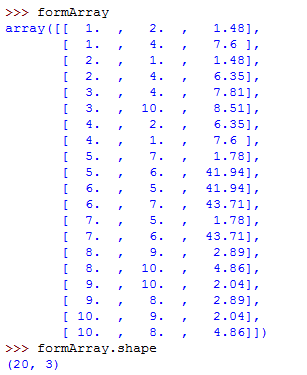
formArray = numpy.array(listArray).reshape(-1,3)
dts = [('IN_OID', '<i4'),('NEAR_OID', '<i4'),('NEAR_DIST', '<f8')]
finalArray = numpy.rec.fromrecords(formArray, dtype = dts)
#export to geodatabase table
arcpy.da.NumPyArrayToTable(finalArray, r'...\ArcGIS\Default.gdb\out_table')How the array structure should look: How the array looks after specifying dtype
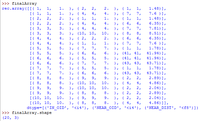
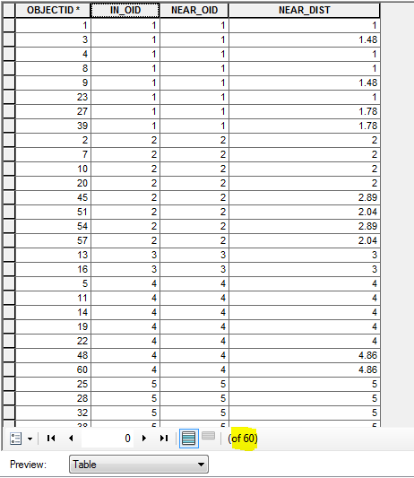
And this is what the output table looks like (notice it has 60 rows... it should only contain 20)
- Mark as New
- Bookmark
- Subscribe
- Mute
- Subscribe to RSS Feed
- Permalink
Don't respecify the dtype. your structured array (and recarrays) will have a dtype with a shape of (N, ) where N is the number of records. You don't reshape a structured array to make it 'look' pretty, because adding that extra dimension will foul up your conversion to a table. My Blog has dozens of posts on the use of numpy including some of the basics etc. So what you had was fine until you reshaped it and added the extra dimension turning each row into 3
- Mark as New
- Bookmark
- Subscribe
- Mute
- Subscribe to RSS Feed
- Permalink
Thanks Dan! I need to somehow convert the first two columns of the array into integer types before converting to a table. If not, the output table has 'Double' type in the ID fields. Which is not ideal. So that's why I tried to specify a dtype. I guess I need to head to your blog and study arrays more. Thanks again!
- Mark as New
- Bookmark
- Subscribe
- Mute
- Subscribe to RSS Feed
- Permalink
Mitch....
Observe (table and properties in Pro)
b
array([(1, 300015.0, 5000005.0, 1, 40.0, 100.0, 1, 4, 1.0, 100.0, 'A 10 chars'),
(2, 300005.0, 5000015.0, 2, 64.0, 64.0, 2, 5, 2.0, 200.0, 'None'),
(3, 300010.4945054945, 5000010.593406593, 3, 99.41640786499875, 182.0, 3, 6, 3.0, 300.0, 'C not null')],
dtype=[('IDs', '<i4'), ('Xc', '<f8'), ('Yc', '<f8'), ('Id', '<i4'),
('Shape_Length', '<f8'), ('Shape_Area', '<f8'), ('Long_1', '<i4'),
('Short_1', '<i4'), ('Float_1', '<f4'), ('Double_1', '<f8'),
('Text_1', '<U10')])
arcpy.da.NumPyArrayToTable(b, r"C:\Git_Dan\a_Data\testdata.gdb\numpy_table")and in Pro
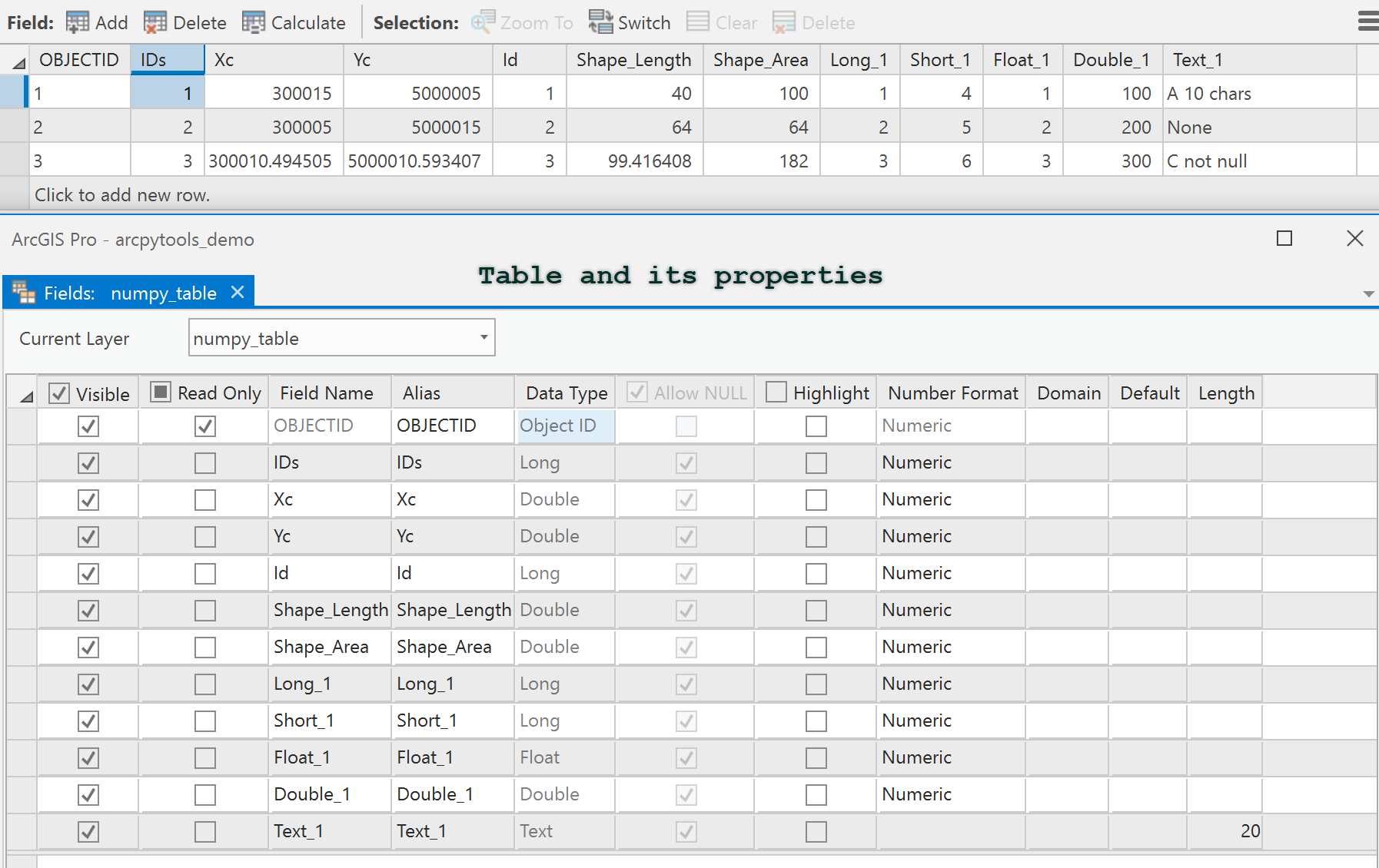
You were working too hard, conversions and dtypes are converted to esri equivalents from numpy