- Home
- :
- All Communities
- :
- Developers
- :
- Python
- :
- Python Questions
- :
- Re: Help modifiying getExtent to get data from onl...
- Subscribe to RSS Feed
- Mark Topic as New
- Mark Topic as Read
- Float this Topic for Current User
- Bookmark
- Subscribe
- Mute
- Printer Friendly Page
Help modifiying getExtent to get data from only 1 layer
- Mark as New
- Bookmark
- Subscribe
- Mute
- Subscribe to RSS Feed
- Permalink
I have the following code:
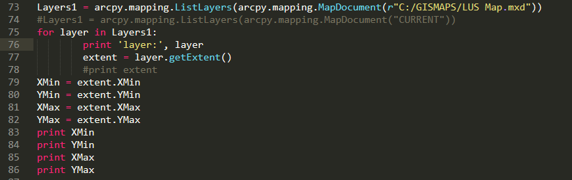
The way it is written it shows all of the layers in my mxd file. I want to change the code so that i only gets the data for 1 layer: Primary OH
How would i change the script to do this?
Thanks
Solved! Go to Solution.
Accepted Solutions
- Mark as New
- Bookmark
- Subscribe
- Mute
- Subscribe to RSS Feed
- Permalink
The Extent—Help | ArcGIS Desktop documentation covers it, albeit maybe not direct enough.
Summary
An extent is a rectangle specified by providing the coordinate of the lower left corner and the coordinate of the upper right corner in map units.
The key is "in map units," which means in the units of the spatial reference for the layer. From looking at the values in your screenshot below, it is obvious the coordinates aren't geographic, so you are working with some projection.
- Mark as New
- Bookmark
- Subscribe
- Mute
- Subscribe to RSS Feed
- Permalink
There are multiple ways to do this, and the ListLayers—Help | ArcGIS Desktop documentation covers this
Syntax
ListLayers (map_document_or_layer, {wildcard}, {data_frame})
Parameter Explanation Data Type A variable that references a MapDocument or Layer object.
Object A combination of asterisks (*) and characters can be used to help limit the results.
(The default value is None)
String A variable that references a DataFrame object.
(The default value is None)
DataFrame
and shows a couple examples:
- Mark as New
- Bookmark
- Subscribe
- Mute
- Subscribe to RSS Feed
- Permalink
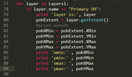
Joshua, Thanks for pointing me in he right direction. This code works. It get floating numbers for the min/max values.
Can you tell me what the number mean - x/y coordinates, feet, etc?
- Mark as New
- Bookmark
- Subscribe
- Mute
- Subscribe to RSS Feed
- Permalink
The Extent—Help | ArcGIS Desktop documentation covers it, albeit maybe not direct enough.
Summary
An extent is a rectangle specified by providing the coordinate of the lower left corner and the coordinate of the upper right corner in map units.
The key is "in map units," which means in the units of the spatial reference for the layer. From looking at the values in your screenshot below, it is obvious the coordinates aren't geographic, so you are working with some projection.
- Mark as New
- Bookmark
- Subscribe
- Mute
- Subscribe to RSS Feed
- Permalink
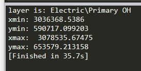
Sorry, i meant to show the numbers that i am getting:
Also, would you know how to make ArcGIS zoom to these coordinates?
Thanks
- Mark as New
- Bookmark
- Subscribe
- Mute
- Subscribe to RSS Feed
- Permalink
Joshua,
Thanks for the help