- Home
- :
- All Communities
- :
- Developers
- :
- Python
- :
- Python Questions
- :
- Re: geometry help w/ da.InsertCursor
- Subscribe to RSS Feed
- Mark Topic as New
- Mark Topic as Read
- Float this Topic for Current User
- Bookmark
- Subscribe
- Mute
- Printer Friendly Page
- Mark as New
- Bookmark
- Subscribe
- Mute
- Subscribe to RSS Feed
- Permalink
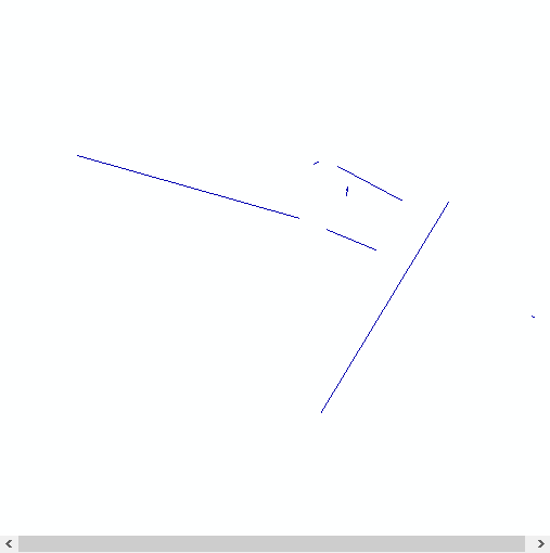
Ok, I'm stumped! I have a list "xys" that if I do this:
xys.sort()
for i in xys:
print i
I get this: (id, xFrom, yFrom, xTo, yTo)
[225351, 1858897, 889223, 1883031, 882436]
[225396, 1908393, 871758, 1908090, 871791]
[225405, 1899127, 884235, 1885213, 861191]
[225423, 1891186, 878961, 1885811, 881262]
[225435, 1887101, 888042, 1894165, 884325]
[225438, 1888139, 885803, 1888050, 885319]
[225438, 1888139, 885803, 1888081, 884837]
[225441, 1885023, 888542, 1884356, 888364]
[225351, 1858897, 889223, 1883031, 882436]
and then i do this:
for j in xys:
print j
myList = []
myList.append(arcpy.Point(j[1], j[2]))
myList.append(arcpy.Point(j[3], j[4]))
array = arcpy.Array(myList)
polyline = arcpy.Polyline(array)
cursor = arcpy.da.InsertCursor(output, ("SHAPE@"))
cursor.insertRow((polyline,))
print 'inserted row'
I get an empty table... I had this working at one point. Any obvious blunders here?
Solved! Go to Solution.
- Mark as New
- Bookmark
- Subscribe
- Mute
- Subscribe to RSS Feed
- Permalink
interesting, but annoying... If I look at the help of the da.InsertCursor at 10.3:
... I see that they use (as Richard Fairhurst suggests) a list for the fields and insert the row as list. So maybe if you make some minor changes it will work in 10.3 (I can't verify this until next week):
import arcpy
fc = r"C:\Forum\DistLinePol\test.gdb\Polyline2"

xys = [[225351, 1858897, 889223, 1883031, 882436],
      [225396, 1908393, 871758, 1908090, 871791],
      [225405, 1899127, 884235, 1885213, 861191],
      [225423, 1891186, 878961, 1885811, 881262],
      [225435, 1887101, 888042, 1894165, 884325],
      [225438, 1888139, 885803, 1888050, 885319],
      [225438, 1888139, 885803, 1888081, 884837],
      [225441, 1885023, 888542, 1884356, 888364],
      [225351, 1858897, 889223, 1883031, 882436]]

with arcpy.da.InsertCursor(fc, ["SHAPE@"]) as cursor:
    for j in xys:
        array = arcpy.Array()
        array.add(arcpy.Point(j[1], j[2]))
        array.add(arcpy.Point(j[3], j[4]))
        polyline = arcpy.Polyline(array)
        cursor.insertRow([polyline])
- Mark as New
- Bookmark
- Subscribe
- Mute
- Subscribe to RSS Feed
- Permalink
inserts worked for me at 10.3.
refresh in catalog maybe?
are the coordinates posted way out of bounds for the coordinate system?
- Mark as New
- Bookmark
- Subscribe
- Mute
- Subscribe to RSS Feed
- Permalink
I agree with Daniel that the code Xander posted (using tuples or lists) works with Python 2.7.8 and ArcMap 10.3. I get the same results he showed. The coordinates work even with my default state plane coordinate system which is not really designed for this data.
Sounds like a reboot is in order if it is not working.
- Mark as New
- Bookmark
- Subscribe
- Mute
- Subscribe to RSS Feed
- Permalink
Reinstalling now. My upgrade must have gone wrong.
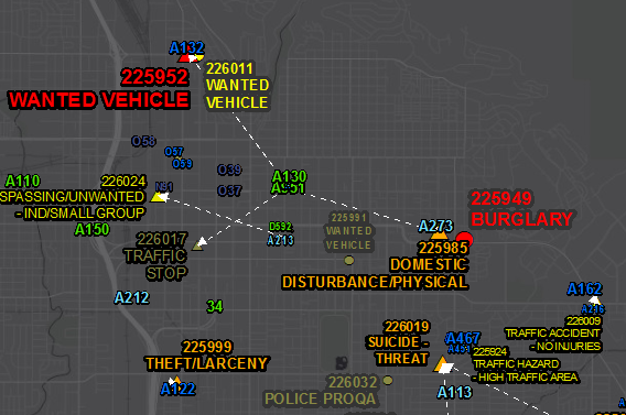
Thanks everyone! The application here's pretty cool. This will be like a live spider diagram showing police officers converging on a call for assistance.
- Mark as New
- Bookmark
- Subscribe
- Mute
- Subscribe to RSS Feed
- Permalink
cool. share a final output when you can .
- Mark as New
- Bookmark
- Subscribe
- Mute
- Subscribe to RSS Feed
- Permalink
Ok, my police "calls for service" map is done with lines showing who's assigned to whatever call! Thanks for your help everyone. (this refreshes every 30 seconds)
- Mark as New
- Bookmark
- Subscribe
- Mute
- Subscribe to RSS Feed
- Permalink
Cool! Nice Work!
- « Previous
-
- 1
- 2
- Next »
- « Previous
-
- 1
- 2
- Next »