- Home
- :
- All Communities
- :
- Developers
- :
- Python
- :
- Python Questions
- :
- Re: Feet to Decimal Degrees function
- Subscribe to RSS Feed
- Mark Topic as New
- Mark Topic as Read
- Float this Topic for Current User
- Bookmark
- Subscribe
- Mute
- Printer Friendly Page
Feet to Decimal Degrees function
- Mark as New
- Bookmark
- Subscribe
- Mute
- Subscribe to RSS Feed
- Permalink
The script is for Washington State South NAD27 and I use Florida State North NAD83. The constants are all in the projection file for Florida North NAD83 except the major radius and the eccentricity. I looked in the projection file for NAD83 and saw that it is built on the GRS1980 spheroid. The Wikipedia page for that spheroid doesn't have those values and there isn't and page dedicated to the values for NAD83. At lease the GRS1980 values which seem to be the ones I may need are named differently from the script so I cant tell if they are the right ones. Any help? I will post this once I get it converted for anyone to steal for their own projects.
- Mark as New
- Bookmark
- Subscribe
- Mute
- Subscribe to RSS Feed
- Permalink
You can achieve this using an Update Cursor. Cursors give you have the ability to set a working coordinate system. Take a look at the 5th post here.
- Mark as New
- Bookmark
- Subscribe
- Mute
- Subscribe to RSS Feed
- Permalink
- Mark as New
- Bookmark
- Subscribe
- Mute
- Subscribe to RSS Feed
- Permalink
Also, unless I am mistaken, the cursor SR parameter doesn't allow for datum transformations, so things could be off by quite a bit.
Safe method:
1. Project your centroid points (using the appropriate datum transformation)
2. Read the coordinates in a search cursor
- Mark as New
- Bookmark
- Subscribe
- Mute
- Subscribe to RSS Feed
- Permalink
- Mark as New
- Bookmark
- Subscribe
- Mute
- Subscribe to RSS Feed
- Permalink
def Ft_DD(x,y):
    ## This function converts coordinates from Florida State Plane North Zone NAD83 feet
    ## to Geographic coordinates in decimal degrees
    ##
    ## The formula this program is based on are from "Map Projections,
    ## A Working Manual" by John P. Snyder, U.S. Geological Survey
    ## Professional Paper 1395, 1987, pages 295-298
    ##
    ##Function originally provided by Dan Saul, Washington State Department of Ecology
    ##
    ## Set up the coordinate system parameters.
    A = 20925604.47                         ## major radius of GRS 1980 ellipsoid, feet
    Ec = 0.0818191910435                    ## eccentricity of GRD 1980 ellipsoid
    Ec2 = Ec * Ec                           ## eccentricity squared
    AngRad = 0.017453292519943299           ## number of radians in a degree
    Pi4 = 3.141592653582 / 4                ## Pi / 4
    P1 = 29.583333333333329000 * AngRad     ## latitude of first standard parallel
    P2 = 30.750000000000000000 * AngRad     ## latitude of second standard parallel
    P0 = 29.000000000000000000 * AngRad     ## latitude of origin
    M0 = -84.5 * AngRad                     ## central meridian
    X0 = 1968500.0                          ## False easting of central meridian, map units

    ## Calculate the coordinate system constants.
    m1 = math.cos(P1) / math.sqrt(1 - (Ec2 * pow((math.sin(P1)),2)))
    m2 = math.cos(P2) / math.sqrt(1 - (Ec2 * pow((math.sin(P2)),2)))
    t1 = math.tan(Pi4 - (P1 / 2)) / pow((1 - Ec * math.sin(P1)) / (1 + Ec * math.sin(P1)),(Ec/2))
    t2 = math.tan(Pi4 - (P2 / 2)) / pow((1 - Ec * math.sin(P2)) / (1 + Ec * math.sin(P2)),(Ec/2))
    t0 = math.tan(Pi4 - (P0 / 2)) / pow((1 - Ec * math.sin(P0)) / (1 + Ec * math.sin(P0)),(Ec/2))
    n = math.log(m1 / m2) / math.log(t1 / t2)
    F = m1 / (n * pow(t1,n))
    rho0 = A * F * pow(t0,n)
    ## Convert the coordinate to Latitude/Longitude.

    ## Calculate the Longitude.
    x = x - X0
    Pi2 = Pi4 * 2
    rho = math.sqrt(pow(x,2) + (pow(rho0 - y,2)))
    theta = math.atan(x/(rho0 - y))
    t = pow(rho / (A * F),(1 / n))
    LonR = theta / n + M0
    x = x + X0

    ## Estimate the Latitude
    Lat0 = Pi2 - (2 * math.atan(t))

    ## Substitute the estimate into the iterative calculation that
    ## converges on the correct Latitude value.
    part1 = (1 - (Ec * math.sin(Lat0))) / (1 + (Ec * math.sin(Lat0)))
    LatR = Pi2 - (2 * math.atan(t * pow(part1,(Ec/2))))

    Lat0 = LatR
    part1 = (1 - (Ec * math.sin(Lat0))) / (1 + (Ec * math.sin(Lat0)))
    ##LatR = Pi2 - (2 * math.atan2((t * (part1**(Ec/2))),1))
    LatR = Pi2 - (2 * math.atan(t * pow(part1,(Ec/2))))
    print LatR,LonR

    if (abs(LatR - Lat0) > 0.000000002):
        ## Convert from radians to degrees.
        Lat = LatR / AngRad
        Lon = LonR / AngRad
    print str(Lon) + "|" + str(Lat)
- Mark as New
- Bookmark
- Subscribe
- Mute
- Subscribe to RSS Feed
- Permalink
Hi Chris,
I need to do similar conversion of California II State Plane in US Survey feet to geographic coordinates in decimal degrees. I am not totally comfortable with python but need to have it in python. I updated the parameters in California values. But not getting desired output. Here is the updated part of the script your wrote in California values:
A = 20925604.47 ## major radius of GRS 1980 ellipsoid, feet
Ec = 0.0818191910435 ## eccentricity of GRD 1980 ellipsoid
Ec2 = Ec * Ec ## eccentricity squared
AngRad = 0.017453292519943299 ## number of radians in a degree
Pi4 = 3.141592653582 / 4 ## Pi / 4
P1 = 38.33333333 * AngRad ## latitude of first standard parallel
P2 = 39.83333333 * AngRad ## latitude of second standard parallel
P0 = 37.66666667 * AngRad ## latitude of origin
M0 = -122 * AngRad ## central meridian
X0 = 6561666.66666667 ## False easting of central meridian, map units
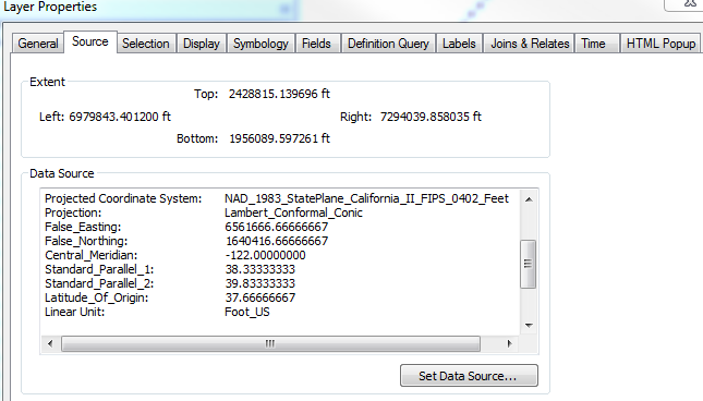
And here is the snapshot of Data Source:
Unsure where the problem is. If it is due to no parameter for False northing or...?
Basically, the sample CA State Plane II x,y: 7079975.52661,2184310.50409 should give me: 39.1457869, -120.1722625 and if I run your code with above updated parameters, I am getting: 43.642324406, -120.048031426.
Any ideas how to fix that would be great!!!
- Mark as New
- Bookmark
- Subscribe
- Mute
- Subscribe to RSS Feed
- Permalink
An alternative perhaps:
import arcpy
x = 7079975.52661
y = 2184310.50409
# WGS 1984 : (4326) Lat/Lon
# NAD_1983_2011_StatePlane_California_II_FIPS_0402_Ft_US - WKID: 6418
ptGeometry = arcpy.PointGeometry(arcpy.Point(x,y),arcpy.SpatialReference(6418)).projectAs(arcpy.SpatialReference(4326))
# print ptGeometry.JSON
print ptGeometry.firstPoint.X, ptGeometry.firstPoint.Y
# Result: -120.172262515 39.1457869508- Mark as New
- Bookmark
- Subscribe
- Mute
- Subscribe to RSS Feed
- Permalink
Thank you Randy. It worked!