- Home
- :
- All Communities
- :
- Developers
- :
- Python
- :
- Python Questions
- :
- Re: Example ArcPro Python Toolboxes
- Subscribe to RSS Feed
- Mark Topic as New
- Mark Topic as Read
- Float this Topic for Current User
- Bookmark
- Subscribe
- Mute
- Printer Friendly Page
- Mark as New
- Bookmark
- Subscribe
- Mute
- Subscribe to RSS Feed
- Permalink
I'm working on my first ArcGIS pro Python Toolbox and running into various problems with bugs/syntax/layer files etc and as I am relatively new I was wondering if there are good python toolboxes examples around specifically for ARCPro around the problems I am running into seem to be specific to the pro/python toolbox combination and sifting through ArcMap, Vanilla Toolbox examples and questions is time consuming.
I'm also starting to suspect that ArcGIS Pro Python Toolboxes just aren't being used in general for basic map automation and maybe I should be looking at something else instead to automate our basic mapping workflows for my team.
Note that I (and my team) will not have named user logins, but will have access to advanced ArcGis pro licences. We expect that the users we deliver the styled maps to will have access to basic licences to adjust thematics, colours etc.
Solved! Go to Solution.
Accepted Solutions
- Mark as New
- Bookmark
- Subscribe
- Mute
- Subscribe to RSS Feed
- Permalink
You might want to investigate 'custom' toolboxes unless you have a desire to write validation code etc.
This is an example toolbox, right-click on any of the tools and select Properties. It will open up the dialog used to define the script, the parameters and the validation code if needed.
Free Tools for ArcGIS Pro: Table Tools
This link....
Comparing custom and Python toolboxes—Geoprocessing and Python | Documentation
and the ones above and below it elaborate on toolboxes more generally.
This link...
will allow you to search for tools that may be more specifically focused to your needs maybe without the need to rewrite the wheel.
... sort of retired...
- Mark as New
- Bookmark
- Subscribe
- Mute
- Subscribe to RSS Feed
- Permalink
Thankyou Dan!
'custom' toolboxes - Interesting response 🙂
I've had a look at the 'custom' toolbox and decided against it as python toolboxes just look a lot more portable between team members with various skillsets. I am actually using a 'custom' toolbox that a previous team member started to develop and working with the parameters was a bit of a learning curve but I'm not having problems there as far as I can tell. If I get more issues I might switch to 'custom toolboxes' instead.
Thankyou so much for your example and the link provided - I figured there must be a code sharing area somewhere but I'm new to geonet as well. I really do not want to rewrite the wheel!
- Mark as New
- Bookmark
- Subscribe
- Mute
- Subscribe to RSS Feed
- Permalink
Leandra Gordon I just usually "zip" the toolbox and a "scripts" folder together, the others just need to unzip it where they want it. The key is to make the scripts "relative" to the toolbox. It is one of the options in the custom toolbox wizard.
ie inside the zip
MyToolbox.tbx
....Scripts folder
.... A.py scripts associated with tools in the toolbox or used as imports
.... B.py
.... etc
... sort of retired...
- Mark as New
- Bookmark
- Subscribe
- Mute
- Subscribe to RSS Feed
- Permalink
I've had a quick look and I'm coming around to your way of thinking. I might give 'custom toolboxes' a go. They seem to be a bit more widely used and that is a plus. Thanks for the advice, I'm at the start of building tools for my team to migrate us away from Mapinfo so I want to make the right choices now rather than later.
- Mark as New
- Bookmark
- Subscribe
- Mute
- Subscribe to RSS Feed
- Permalink
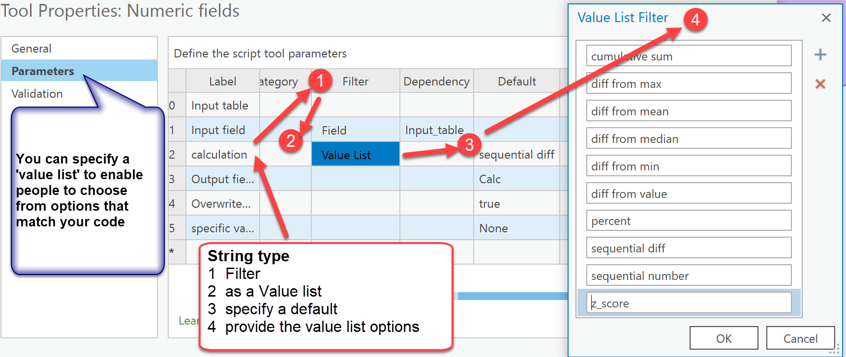
I will add, one of my big reasons too, is that I do screen grabs of the wizard showing how all the parameters are set for each tool, so I don't have to rely on a verbal description as to whether a parameter is input, output or derived and if I use 'value list' 's, what the defaults are and your thumbnails.I can then produce a pdf for a toolset.

... sort of retired...