- Home
- :
- All Communities
- :
- Developers
- :
- Python
- :
- Python Questions
- :
- Creating a raster based on extent coordinates
- Subscribe to RSS Feed
- Mark Topic as New
- Mark Topic as Read
- Float this Topic for Current User
- Bookmark
- Subscribe
- Mute
- Printer Friendly Page
Creating a raster based on extent coordinates
- Mark as New
- Bookmark
- Subscribe
- Mute
- Subscribe to RSS Feed
- Permalink
Hi! I will highly appreciate your help in matter that I am struggling with since few days. I would like to create a hazard map of selected area. I read that in order to do that, I need to create a raster and assign the values to each cell (and later add colors). I don't want to convert selected polygon to raster because I would like it to be visible when selected ( I would imagine it like showed on image in attachment). The process I started by creating an extent of the polygon in order to define Xmin, Xmax, Ymin and Ymax for future raster (see attachment). Later on I tried to calculate a length of raster sides and its area. I though that thanks to that I will be able to define cell size. Nevertheless when I run a script I receive errors about wrong parameter. I have to say that I am quite a beginner in python and I really don't know what I am doing wrong. I tried to change a code using many examples that I found but still errors occurred. Many thanks in advance for any opinions, suggestions, tips and comments!.
Regards,
Paulina
My code:
class NetButton(object):
"""Implementation for NetButton.button (Button)"""
def __init__(self):
self.enabled = True
self.checked = False
def onClick(self):
fc = ExcavationZone
ExtentOutput="\\\\abc\\home\\xyz\\Documents\\moje dokumenty\\xxx\\arcgis\\ExtentOutput"
mxd = arcpy.mapping.MapDocument ("CURRENT")
sr = mxd.activeDataFrame.spatialReference #RD_NEW
desc = arcpy.Describe(fc)
extent = desc.extent
pts = [arcpy.Point(extent.XMin, extent.YMin),
arcpy.Point(extent.XMax, extent.YMin),
arcpy.Point(extent.XMax, extent.YMax),
arcpy.Point(extent.XMin, extent.YMax)]
#print extent.XMin,extent.YMin,extent.XMax,extent.YMax
print ("XMax:",extent.XMax,"YMax:",extent.YMax)
print ("XMin:",extent.XMin,"YMin:",extent.YMin)
print ("XMax:",extent.XMax,"YMin:",extent.YMin)
print ("XMax:",extent.XMin,"YMax:",extent.YMax)
#Create raster: my trial
#CreateRasterDataset_management (out_path, out_name, {cellsize}, pixel_type, {raster_spatial_reference}, number_of_bands, {config_keyword}, {pyramids}, {tile_size}, {compression}, {pyramid_origin})
RiskMapRaster="\\\\abc\\home\\xyz\\Documents\\moje dokumenty\\xxx\arcgis\\riskmapraster"
c=int(extent.XMax-extent.XMin)
print c
d=int(extent.YMax-extent.YMin)
print d
cellsize= int(c*d)
print cellsize
arcpy.CreateRasterDataset_management ("RiskMapRaster", "", "cellsize", "16_BIT_UNSIGNED", "sr", "1", "", "PYRAMIDS -1 NEAREST JPEG", "", "NONE", "")
print "Done!"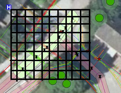