- Home
- :
- All Communities
- :
- Developers
- :
- Python
- :
- Python Questions
- :
- Re: create PDF for every polygon in the geodata.
- Subscribe to RSS Feed
- Mark Topic as New
- Mark Topic as Read
- Float this Topic for Current User
- Bookmark
- Subscribe
- Mute
- Printer Friendly Page
create PDF for every polygon in the geodata.
- Mark as New
- Bookmark
- Subscribe
- Mute
- Subscribe to RSS Feed
- Permalink
Hello,
I have the attribute table of Polygon. I would like to create Pdf for every polygon shape separately using Python Script. Can anyone suggest me?
- Mark as New
- Bookmark
- Subscribe
- Mute
- Subscribe to RSS Feed
- Permalink
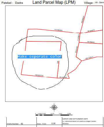
Is it possible can we make separate color?
- Mark as New
- Bookmark
- Subscribe
- Mute
- Subscribe to RSS Feed
- Permalink
Use feature to line,split lines at vetices to get your polygons as lines to be able to label the distances if you use a unique identifier for your polygons you can use that same identifier to show your labeled lines this is also a property of data driven pages as mentioned above.
- Mark as New
- Bookmark
- Subscribe
- Mute
- Subscribe to RSS Feed
- Permalink
Finding symbols—Help | ArcGIS for Desktop check out help on changing symbology to draw in different colors. You will have to have a unique identifier of the different classifications to symbolize. See Wes's response about splitting lines...the create/calc a new unique field if necessary.
Raj, these questions are getting away from your original question. You should Mark a reply as the Correct Answer and then fork these other questions as new questions. That will help others find solutions to you questions (vs having them get buried in one thread)
- Mark as New
- Bookmark
- Subscribe
- Mute
- Subscribe to RSS Feed
- Permalink
Hello Raj et al,
I would recommend using a parcel fabric. Every polygon has it's own set of lines and you will get many more benefits from it. The Land Records meetup has a whole session about printing maps using Data Driven Pages and dynamic elements (once you are a member open this page). After you watch the technical session you can download the Tax Parcel Map Book that is a part of the solution and use it as template.
Everything you are trying to do can be achieved without writing any code and in a couple of hours (excluding layout design)
Please also note that any dimension you show on the line converted from the polygon will be the inversed geometry using the GRID (projection) spatial reference that will not match the actual distance on the ground nor the legal document. If you want to do this correctly you have to use the parcel editing tools and a parcel fabric that are part of ArcGIS Desktop.
Amir
- Mark as New
- Bookmark
- Subscribe
- Mute
- Subscribe to RSS Feed
- Permalink
Hello,
I would to make separate colour for the current layout view in the polygon attribute table.
- Mark as New
- Bookmark
- Subscribe
- Mute
- Subscribe to RSS Feed
- Permalink
When you create your lines and use the unique identifier for the data driven pages, on the lines feature class you will be able to set a page definition that will allow only the lines for that unique identifier to show you can make those lines any color you want, so they will contrast with the surrounding polygons
- « Previous
-
- 1
- 2
- Next »
- « Previous
-
- 1
- 2
- Next »