- Home
- :
- All Communities
- :
- Developers
- :
- Python
- :
- Python Questions
- :
- Re: Create lines from points and cut rectangle wit...
- Subscribe to RSS Feed
- Mark Topic as New
- Mark Topic as Read
- Float this Topic for Current User
- Bookmark
- Subscribe
- Mute
- Printer Friendly Page
Create lines from points and cut rectangle with line and assign attributes
- Mark as New
- Bookmark
- Subscribe
- Mute
- Subscribe to RSS Feed
- Permalink
Ok, attached I have the point data and the rectangle as polygon. I want to draw vertical line from each point (from the top to the bottom) and keep the information written in the LN column. After I want to make single polygons (resulting from the underlying rectangle and the lines together) and also keep the LN information in the single polygons. So in the end it shoudl be 13 single polygons, I hope you understand what I mean.
Best,
Tim
Branched from: https://community.esri.com/thread/176544
Solved! Go to Solution.
Accepted Solutions
- Mark as New
- Bookmark
- Subscribe
- Mute
- Subscribe to RSS Feed
- Permalink
Hi Tim Gattinger , see below the code I created based on the information in the point shapefile:
#-------------------------------------------------------------------------------
# Name: create_rectangles.py
# Purpose:
#
# Author: Xander
#
# Created: 01-04-2017
#-------------------------------------------------------------------------------
import arcpy
import os
def main():
arcpy.env.overwriteOutput = True
# parameters
fc_in = r'C:\GeoNet\GW1\ref_kal_ln\ref_kal_ln.shp'
fc_out = r'C:\GeoNet\GW1\rectangles_v01.shp'
where = '"ID" <14'
fld_x_max = 'X'
fld_y_max = 'Y'
fld_width = 'width'
fld_height = 'length'
# create output featureclass
sr = arcpy.Describe(fc_in).spatialReference
CreateFeatureClassTemplate(fc_out, fc_in, "POLYGON", fc_in, sr)
# nested insert and search cursor
flds = GetAllFieldsWithoutSystemFields(fc_in)
with arcpy.da.InsertCursor(fc_out, flds) as curs_out:
with arcpy.da.SearchCursor(fc_in, flds, where) as curs:
for row in curs:
x_max = row[flds.index(fld_x_max)]
y_max = row[flds.index(fld_y_max)]
width = row[flds.index(fld_width)]
height = row[flds.index(fld_height)]
polygon = CreateRectangle(x_max, y_max, width, height, sr)
if polygon is not None:
lst_row = list(row)
lst_row[0] = polygon
row_out = tuple(lst_row)
curs_out.insertRow(row_out)
def GetAllFieldsWithoutSystemFields(fc):
flds = [fld.name for fld in arcpy.ListFields(fc)]
desc = arcpy.Describe(fc)
fld_shape = desc.shapeFieldName
fld_oid = desc.OIDFieldName
for fld_name in [fld_shape, fld_oid]:
if fld_name in flds:
flds.pop(flds.index(fld_name))
flds.insert(0, 'SHAPE@')
return flds
def CreateFeatureClassTemplate(fc_out, fc_in, geomtype, template, sr):
ws_name, fc_name = os.path.split(fc_out)
arcpy.CreateFeatureclass_management(ws_name, fc_name, geomtype, template, spatial_reference=sr)
def CreateRectangle(x_max, y_max, width, height, sr):
pnt1 = arcpy.Point(x_max - width, y_max - height)
pnt2 = arcpy.Point(x_max - width, y_max)
pnt3 = arcpy.Point(x_max, y_max)
pnt4 = arcpy.Point(x_max, y_max - height)
lst_pnts = [pnt1, pnt2, pnt3, pnt4, pnt1]
return arcpy.Polygon(arcpy.Array(lst_pnts), sr)
if __name__ == '__main__':
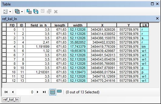
main()The upper part of the shapefile looks like this:
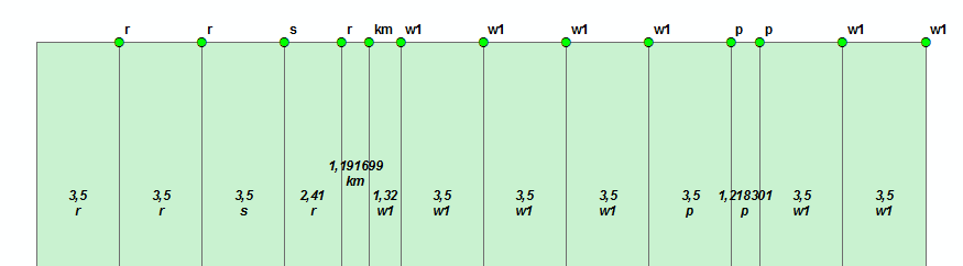
The attribute table of the resulting shapefile (attributes are transferred):
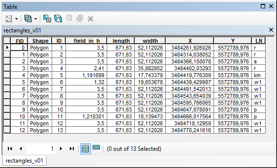
I have attached the resulting shapefile for you to examine.
- Mark as New
- Bookmark
- Subscribe
- Mute
- Subscribe to RSS Feed
- Permalink
When I look at the data I see that you are using a format (point featureclass) that is different from the original format used in the thread Create a line from points using attributes
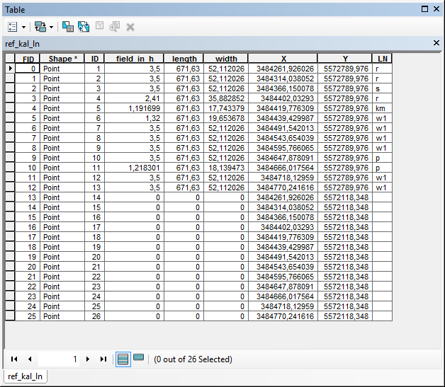
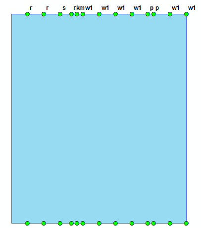
I understand that you want to create vertical lines and use these to cut a rectangle in smaller parts in order to generate the smaller rectangles and assign values from the attributes of the input points. This may not be as straight forward as you hope, since the input points do not hold details on which points should be used together to form the line (although this will probably be those with the same X-coordinates):
I would like to suggest another input format (if possible) to make this process a lot easier. You basically have a constant Y (min and max) and a Xmin. When you know the width of each rectangle and you start with Xmin and apply the width you will be able to form the rectangles with little effort and it will be easy to maintain the attributes (for instance field LN):
Could you elaborate a little on what the data represents and where it comes from and what you want to achieve (apart from the smaller rectangles)?
Kind regards, Xander
- Mark as New
- Bookmark
- Subscribe
- Mute
- Subscribe to RSS Feed
- Permalink
Hi Tim Gattinger , see below the code I created based on the information in the point shapefile:
#-------------------------------------------------------------------------------
# Name: create_rectangles.py
# Purpose:
#
# Author: Xander
#
# Created: 01-04-2017
#-------------------------------------------------------------------------------
import arcpy
import os
def main():
arcpy.env.overwriteOutput = True
# parameters
fc_in = r'C:\GeoNet\GW1\ref_kal_ln\ref_kal_ln.shp'
fc_out = r'C:\GeoNet\GW1\rectangles_v01.shp'
where = '"ID" <14'
fld_x_max = 'X'
fld_y_max = 'Y'
fld_width = 'width'
fld_height = 'length'
# create output featureclass
sr = arcpy.Describe(fc_in).spatialReference
CreateFeatureClassTemplate(fc_out, fc_in, "POLYGON", fc_in, sr)
# nested insert and search cursor
flds = GetAllFieldsWithoutSystemFields(fc_in)
with arcpy.da.InsertCursor(fc_out, flds) as curs_out:
with arcpy.da.SearchCursor(fc_in, flds, where) as curs:
for row in curs:
x_max = row[flds.index(fld_x_max)]
y_max = row[flds.index(fld_y_max)]
width = row[flds.index(fld_width)]
height = row[flds.index(fld_height)]
polygon = CreateRectangle(x_max, y_max, width, height, sr)
if polygon is not None:
lst_row = list(row)
lst_row[0] = polygon
row_out = tuple(lst_row)
curs_out.insertRow(row_out)
def GetAllFieldsWithoutSystemFields(fc):
flds = [fld.name for fld in arcpy.ListFields(fc)]
desc = arcpy.Describe(fc)
fld_shape = desc.shapeFieldName
fld_oid = desc.OIDFieldName
for fld_name in [fld_shape, fld_oid]:
if fld_name in flds:
flds.pop(flds.index(fld_name))
flds.insert(0, 'SHAPE@')
return flds
def CreateFeatureClassTemplate(fc_out, fc_in, geomtype, template, sr):
ws_name, fc_name = os.path.split(fc_out)
arcpy.CreateFeatureclass_management(ws_name, fc_name, geomtype, template, spatial_reference=sr)
def CreateRectangle(x_max, y_max, width, height, sr):
pnt1 = arcpy.Point(x_max - width, y_max - height)
pnt2 = arcpy.Point(x_max - width, y_max)
pnt3 = arcpy.Point(x_max, y_max)
pnt4 = arcpy.Point(x_max, y_max - height)
lst_pnts = [pnt1, pnt2, pnt3, pnt4, pnt1]
return arcpy.Polygon(arcpy.Array(lst_pnts), sr)
if __name__ == '__main__':
main()The upper part of the shapefile looks like this:
The attribute table of the resulting shapefile (attributes are transferred):
I have attached the resulting shapefile for you to examine.
- Mark as New
- Bookmark
- Subscribe
- Mute
- Subscribe to RSS Feed
- Permalink
Dear Xander,
may I send you a message? Afaik in this community it only works if you would follow me..
- Mark as New
- Bookmark
- Subscribe
- Mute
- Subscribe to RSS Feed
- Permalink
Sure, I will follow you.