- Home
- :
- All Communities
- :
- Developers
- :
- Python
- :
- Python Questions
- :
- Cost path values are smaller than cost surface
- Subscribe to RSS Feed
- Mark Topic as New
- Mark Topic as Read
- Float this Topic for Current User
- Bookmark
- Subscribe
- Mute
- Printer Friendly Page
Cost path values are smaller than cost surface
- Mark as New
- Bookmark
- Subscribe
- Mute
- Subscribe to RSS Feed
- Permalink
Hi All,
I'm recently do cost path calculations using cost distance and cost surface layer.
My cost surface values are between 1 to 19 (to simplify).
The result that made me confused was the final cost path surface really small, smaller than cost surface's.
Cost path values are around 0.00....
I use cost surface cell size of 30 m * 30 m.
And it calculated with model builder and python script which result the same values.
Is there anything I missed?
Thank you,
[bayu]
Solved! Go to Solution.
Accepted Solutions
- Mark as New
- Bookmark
- Subscribe
- Mute
- Subscribe to RSS Feed
- Permalink
No, you should be using projected data when performing these types of analysis that is why your outputs are in decimal degrees. Project your data to a suitable projected coordinate system specifying an appropriate cell size and extent and try the analysis again. Also, why are your origin and destination points so close together?
- Mark as New
- Bookmark
- Subscribe
- Mute
- Subscribe to RSS Feed
- Permalink
do you mean the size of the raster is much smaller than the input raster? or do you mean the values are smaller than you expect? Is there a chance that you didn't specify/check you Environments options in the Cost Path tool? or within the script or model that you use? Don't assume that the extents have been set, nor previously set extents maintained. Another possibility is that you path may not have reached a destination because it can't be reached. If you have any screen grabs to show what you mean, they would be useful
- Mark as New
- Bookmark
- Subscribe
- Mute
- Subscribe to RSS Feed
- Permalink
Hi Dan,
I mean the values which smaller than I expected.
Below are the screenshots of cost path and cost surface values.
1) cost path
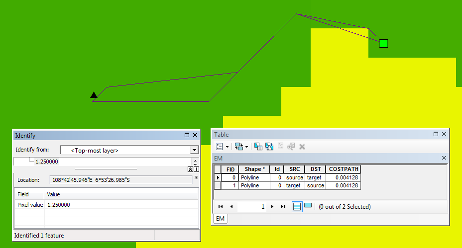
The pic above contains 2 lines (a to b and b to a) with same costpath values (0.004128).
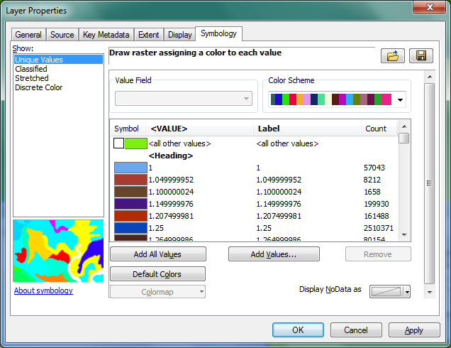
2) cost surface (symbology's unique values: 1 to 25.4)
Here is the python cost path parameter used:
costPath = arcpy.gp.CostPath_sa(DPath, CostDis_shp9, COSTBACKLINK, CostPat_shp6, "EACH_CELL", "FID")
Thanks,
- Mark as New
- Bookmark
- Subscribe
- Mute
- Subscribe to RSS Feed
- Permalink
are your maps in unprojected coordinates (ie in decimal degrees)?
- Mark as New
- Bookmark
- Subscribe
- Mute
- Subscribe to RSS Feed
- Permalink
Did you mean my cost surface layer?
I checked it was GCS_WGS_1984.
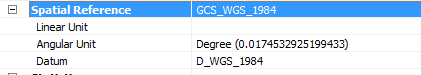
Is it correct?
- Mark as New
- Bookmark
- Subscribe
- Mute
- Subscribe to RSS Feed
- Permalink
No, you should be using projected data when performing these types of analysis that is why your outputs are in decimal degrees. Project your data to a suitable projected coordinate system specifying an appropriate cell size and extent and try the analysis again. Also, why are your origin and destination points so close together?
- Mark as New
- Bookmark
- Subscribe
- Mute
- Subscribe to RSS Feed
- Permalink
OK, I will change the projection and recalculate.
About the short distance, it's only for a quick calculations 🙂
I will update the result soon.
Thanks!
- Mark as New
- Bookmark
- Subscribe
- Mute
- Subscribe to RSS Feed
- Permalink
Make sure you use the appropriate Project tool and not the Define Projection tool
- Mark as New
- Bookmark
- Subscribe
- Mute
- Subscribe to RSS Feed
- Permalink
Final result should looks fine now.
It's another lines (path) calculations:
Before: 0.00706413015723
After: 762.926025391
One question,
Is it already correct since it's still contains decimal?
- Mark as New
- Bookmark
- Subscribe
- Mute
- Subscribe to RSS Feed
- Permalink
762 ish meters ...