- Home
- :
- All Communities
- :
- Developers
- :
- Python
- :
- Python Questions
- :
- Re: Conditional Statement with ArcPy.GetParameters...
- Subscribe to RSS Feed
- Mark Topic as New
- Mark Topic as Read
- Float this Topic for Current User
- Bookmark
- Subscribe
- Mute
- Printer Friendly Page
Conditional Statement with ArcPy.GetParameters as Text, Need to Update Latitude and Longitude Based on User Pref
- Mark as New
- Bookmark
- Subscribe
- Mute
- Subscribe to RSS Feed
- Permalink
#python #ArcPy #for #syntaxerror
I am updating this tool that calculates the latitude and longitude values for all node poles. Originally the user could select Original Latitude and Longitude or Adjusted Latitude and Longitude. The selection was for one or the other. The update allows the user to select both. It utilizes #arcpy.GetParametersAsText . I created a new variable for the selection of Both, Original and Adjusted. In doing this, I created a syntax error in my conditional statement ( line 49), and I cannot figure out how to fix it. Any help on the error (or completing the tool, I imagine I have a few more errors left) would be much appreciated.
#########################################################################################################################
# Name: Calculate Node - Locations
# Author: Heather Wigell
# Description: This tool calculates the latitude and longitude values for all node poles
##################################################################
#########################
# Import system modules
#########################
import arcpy
#########################
# Set universal variables
#########################
nodeFeatures = r'OSP Mapping Layers\Node Locations'
inTable = nodeFeatures
orig_adj = arcpy.GetParameterAsText(0)
mxd = map.MapDocument("CURRENT")
################
#parameters
arcpy.GetParameterAsText(0) = "Original or Adjusted Lat Long"
orig_adj = arcpy.GetParameterAsText(0)
name = 'orig_adj'
displayName = "Original or Adjusted Lat Long"
datatype = 'String'
direction = 'Input'
filters[0].list = ['Original', 'Adjusted', 'Both']
filters[1].type = 'ValueList'
######################
#local variables
latField = "OriginalLatitude"
longField = "OriginalLongitude"
adlatField = "AdjustedLatitude"
adlongField = "AdjustedLongitude"
btlatField = "OriginalLatitude" + "AdjustedLatitude"
btlongField = "OriginalLongitude" + "AdjustedLongitude"
mxd = map.MapDocument("CURRENT")
###########
#add message about coordinate options
arcpy.AddMessage("Are you updating the Original or Adjusted coordinates?")
#############
#Print Parameter Value (User Input {Original, Adjusted, Both}) on Line 49.
arcpy.GetParameterAsText(0)
arcpy.SetParameterAsText(0,x)
x
###############
#pick original, adjusted, or both and match it to ValueList
def(x)
if:
x == "Original" = 'true'
and x == "Original" = 'true'
latField = "OriginalLatitude"
longField = "OriginalLongitude";
elif x == "Adjusted" = 'true'
and x = "Adjusted" = 'true'
adlatField = "AdjustedLatitude"
adlongField = "AdjustedLongitude";
else: x == "Both" = 'true'
btlatField == "BothLatitude"
btlongField = "BothLongitude"
#########################
# Calulate latitude
#########################
# Start message
arcpy.AddMessage("Calculating the latitude values for all node features...")
# Set local variables
expression = "!Shape.Centroid.Y!"
# Execute CalculateField
arcpy.CalculateField_management(inTable, latField, adlatField, btlatField, expression, "PYTHON_9.3", "")
# End message
arcpy.AddMessage("The latitude values have been calculated for all node features!")
arcpy.AddMessage("...")
arcpy.AddMessage("...")
#########################
# Calculate Longitude
#########################
# Start message
arcpy.AddMessage("Calculating the longitude values for all node features...")
# Set local variables
expression = "!Shape.Centroid.X!"
# Execute CalculateField
arcpy.CalculateField_management(inTable, longField, adlongField, btlongField, expression, "PYTHON_9.3", "")
# End message
arcpy.AddMessage("The longitude values have been calculated for all node features!")
arcpy.AddMessage("...")
arcpy.AddMessage("...")
################################################################################ Name: Calculate Node - Locations# Author: Heather Wigell# Description: This tool calculates the latitude and longitude values for all node poles############################################################################################ Import system modules#########################import arcpy########################## Set universal variables#########################nodeFeatures = r'OSP Mapping Layers\Node Locations'inTable = nodeFeaturesorig_adj = arcpy.GetParameterAsText(0)mxd = map.MapDocument("CURRENT")#################parametersarcpy.GetParameterAsText(0) = "Original or Adjusted Lat Long"orig_adj = arcpy.GetParameterAsText(0)name = 'orig_adj',displayName = "Original or Adjusted Lat Long",datatype = 'String',direction = 'Input',filters[0].list = ['Original', 'Adjusted', 'Both']filters[1].type = 'ValueList'#######################local variableslatField = "OriginalLatitude"longField = "OriginalLongitude"adlatField = "AdjustedLatitude"adlongField = "AdjustedLongitude"btlatField = "OriginalLatitude" + "AdjustedLatitude"btlongField = "OriginalLongitude" + "AdjustedLongitude"mxd = map.MapDocument("CURRENT")############add message about coordinate optionsarcpy.AddMessage("Are you updating the Original or Adjusted coordinates?")##############pick original, adjusted, or both and match it to ValueListarcpy.GetParameterAsText(0) for "Original or Adjusted Lat Long"arcpy.SetParameterAsText(0) for "Original or Adjusted Lat Long"if ValueList: "Original" and "Original or Adjusted Lat Long": "Original" latField = "OriginalLatitude" longField = "OriginalLongitude";elif ValueList = "Adjusted": and adj = "Adjusted" adlatField = "AdjustedLatitude" adlongField = "AdjustedLongitude" else: ValueList = "Both" btlatField == "BothLatitude" btlongField = "BothLongitude"########################## Calulate latitude########################## Start messagearcpy.AddMessage("Calculating the latitude values for all node features...")# Set local variablesexpression = "!Shape.Centroid.Y!"# Execute CalculateFieldarcpy.CalculateField_management(inTable, latField, adlatField, btlatField, expression, "PYTHON_9.3", "")# End messagearcpy.AddMessage("The latitude values have been calculated for all node features!")arcpy.AddMessage("...")arcpy.AddMessage("...")########################## Calculate Longitude########################## Start messagearcpy.AddMessage("Calculating the longitude values for all node features...")# Set local variablesexpression = "!Shape.Centroid.X!"# Execute CalculateFieldarcpy.CalculateField_management(inTable, longField, adlongField, btlongField, expression, "PYTHON_9.3", "")# End messagearcpy.AddMessage("The longitude values have been calculated for all node features!")arcpy.AddMessage("...")arcpy.AddMessage("...")- Mark as New
- Bookmark
- Subscribe
- Mute
- Subscribe to RSS Feed
- Permalink
Could you post a screenshot of the error? Your line 49 appears to be blank, so it's probably not causing the syntax error.
- Mark as New
- Bookmark
- Subscribe
- Mute
- Subscribe to RSS Feed
- Permalink
arcpy.SetParameterAsText in this case the index number should be 1 you already havearcpy.GetParameterAsText index set at 0. also you need to set x = "something" before set parameter as text
- Mark as New
- Bookmark
- Subscribe
- Mute
- Subscribe to RSS Feed
- Permalink
Originally, the error was on error Line 54. I added to the code and now I am getting an error on 53 also. They are both generating the same errors.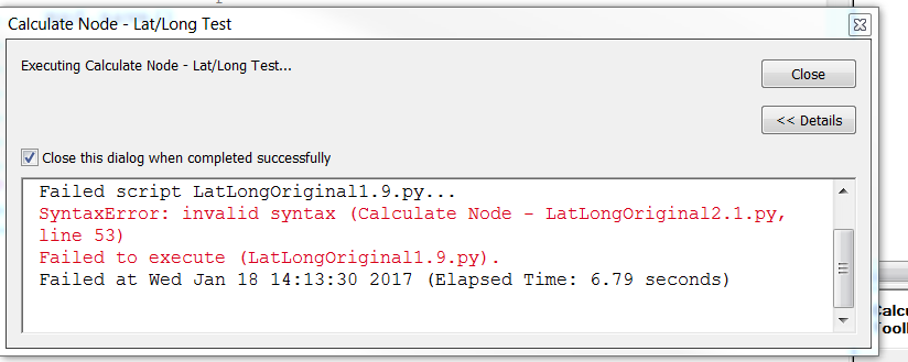
- Mark as New
- Bookmark
- Subscribe
- Mute
- Subscribe to RSS Feed
- Permalink
Since the Syntax Highlighter can do funky things with formatting at times, can you upload the script in a ZIP file?
- Mark as New
- Bookmark
- Subscribe
- Mute
- Subscribe to RSS Feed
- Permalink
Joshua,
Thank you for your comments. Here is the zip file. The original project file has CP at the end. You will see, I changed directions a few times. Zip file
Regards,
Heather
- Mark as New
- Bookmark
- Subscribe
- Mute
- Subscribe to RSS Feed
- Permalink
I think line 48 in the 2.1 version of the script in the zip file (lines 48-52 in the code block of your original post) should read:
x = arcpy.GetParameterAsText(0)Also lines 53-67 of the zip file (lines 57-71 in your original post) has indentation problems. This section does not appear to be a properly defined function, and the if else syntax appears incorrect.
- Mark as New
- Bookmark
- Subscribe
- Mute
- Subscribe to RSS Feed
- Permalink
Thank you, Randy. 57-71 is what I was referring to in my question with syntax. Do you have any specific advice on this section? Or anyone else?
- Mark as New
- Bookmark
- Subscribe
- Mute
- Subscribe to RSS Feed
- Permalink
If I am understanding what you are trying to accomplish, I would suggest something like:
import arcpy
# set up the input table
nodeFeatures = r'OSP Mapping Layers\Node Locations'
inTable = nodeFeatures
# GetParametersAsText will set latField and longField to the
# names of the field to be calculated
x = arcpy.GetParameterAsText(0)
if x == "Original":
latField = "OriginalLatitude"
longField = "OriginalLongitude"
elif x == "Adjusted":
latField = "AdjustedLatitude"
longField = "AdjustedLongitude"
else:
# assume x == "Both" (or add error code as needed)
latField = "BothLatitude"
longField = "BothLongitude"
# the calculation expression
expression = "!Shape.Centroid.Y!"
# CalculateField_management (in_table, field, expression, {expression_type}, {code_block})
# help page: http://desktop.arcgis.com/en/arcmap/10.3/tools/data-management-toolbox/calculate-field.htm
arcpy.CalculateField_management(inTable, latField, expression, "PYTHON_9.3")
expression = "!Shape.Centroid.X!"
arcpy.CalculateField_management(inTable, longField, expression, "PYTHON_9.3")
Please note that I have simplified the code to show the major parts. I may have omitted code that you are using for other purposes.