- Home
- :
- All Communities
- :
- Developers
- :
- Python
- :
- Python Questions
- :
- Calulate geometry results in ArcMap vs. ArcGIS Pro
- Subscribe to RSS Feed
- Mark Topic as New
- Mark Topic as Read
- Float this Topic for Current User
- Bookmark
- Subscribe
- Mute
- Printer Friendly Page
Calulate geometry results in ArcMap vs. ArcGIS Pro
- Mark as New
- Bookmark
- Subscribe
- Mute
- Subscribe to RSS Feed
- Permalink
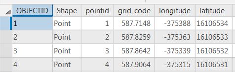
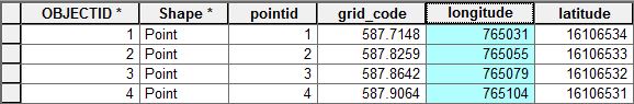
When attempting to calculate geometry for X coord and Y coord in ArcMap and then in ArcGIS Pro the results for the X coord are different, (Y coord results are the same). See the attached jpegs with results. Both were calculated in interactive sessions. I believe the results from ArcMap are correct after comparing to surveyed values. The end result are calculations from geographic coordinates to UTM Zone 15N, NAD83, feet. So, I'm hoping to run a python script that will loop thru 1,455 layers and get the "right" results. I have tried running a script in ArcGIS Pro but get erroneous X coord results. When running the same script in ArcMap (below) the error message shows up. Any help would be appreciated!
>>> import arcpy
>>> arcpy.env.overwriteOutput = 1
>>> outrastertopoint = r"S:/General-Offices-GO-Trans/SLR-Mapping/GIS_Projects_2018/Smart_T_Line_Model/geodata/RASTERTOPOINT_TEST2.gdb/"
>>> arcpy.env.workspace = outrastertopoint
>>> featureClassList = arcpy.ListFeatureClasses()
>>> for featureClass in featureClassList:
... arcpy.management.CalculateGeometryAttributes(featureClass, "X_coord POINT_X;Y_coord POINT_Y", None, None, "PROJCS['NAD 1983 UTM Zone 15N_1',GEOGCS['GCS_North_American_1983',DATUM['D_North_American_1983',SPHEROID['GRS_1980',6378137.0,298.257222101]],PRIMEM['Greenwich',0.0],UNIT['Degree',0.0174532925199433]],PROJECTION['Transverse_Mercator'],PARAMETER['False_Easting',500000.0],PARAMETER['False_Northing',0.0],PARAMETER['Central_Meridian',-93.0],PARAMETER['Scale_Factor',0.9996],PARAMETER['Latitude_Of_Origin',0.0],UNIT['Feet',0.3048]]")
...
Runtime error
Traceback (most recent call last):
File "<string>", line 1, in <module>
TypeError: 'NoneType' object is not iterable
>>> - Mark as New
- Bookmark
- Subscribe
- Mute
- Subscribe to RSS Feed
- Permalink
the error message means that listfeatureclasses returns None, so you can't cycle through it.
The reason? I suspect that the "/" after *.gdb is the culprit... remove it.
As for your Longitude/Latitude (poorly named columns, how about EastingFT, NorthingsFT) something is wrong, check manually