- Home
- :
- All Communities
- :
- Developers
- :
- Python
- :
- Python Questions
- :
- Calculate Field - Convert Meters to Feet
- Subscribe to RSS Feed
- Mark Topic as New
- Mark Topic as Read
- Float this Topic for Current User
- Bookmark
- Subscribe
- Mute
- Printer Friendly Page
- Mark as New
- Bookmark
- Subscribe
- Mute
- Subscribe to RSS Feed
- Permalink
I am trying to calculate a field from the SHAPE.LEN field and convert it from meters to feet....
I ran the calculate field in ArcPro and it worked fine.. I exported the Python and it gave me this
import arcpy
arcpy.management.CalculateField("GIS_DATA.SDE_DITCHING", "LENGTH_FT", "MetersToFeet((float(!SHAPE.LEN!)))", "PYTHON3", """import math
def MetersToFeet(length):
    return (3.280839895) * length
""", "TEXT", "NO_ENFORCE_DOMAINS")
ANY THOUGHTS on why this is failing?
I now want to put this in a stand alone .py script that I will run with a bunch of other code... I did this and am getting this error... I tried all
import arcpy

layers_to_Update = {
"DitchingLayers": "Database Connections\\DEV@gis_data.sde\\GIS_DATA.SDE_DITCHING"
}

def updateLengthField():
    for layer in layers_to_Update.keys():
        fromSDE = layer
        updateLayer = layers_to_Update[layer]
        fieldUpdate = "LENGTH_FT"
        arcpy.env.workspace = "Database Connections\\DEV@gis_data.sde"

        arcpy.management.CalculateField(updateLayer, fieldUpdate, "MetersToFeet((float(!SHAPE.LEN!)))", "PYTHON3", """import math
        def MetersToFeet(length):
            return (3.280839895) * length
        """, "TEXT", "NO_ENFORCE_DOMAINS")

if __name__ == '__main__':
    updateLengthField()
ERROR:
arcgisscripting.ExecuteError: Failed to execute. Parameters are not valid.
ERROR 000989: Python syntax error: File "<string>", line 2
def MetersToFeet(length):
^
IndentationError: unexpected indent
Failed to execute (CalculateField).
I then tried this and got this error
import arcpy

layers_to_Update = {
"DitchingLayers": "Database Connections\\DEV@gis_data.sde\\GIS_DATA.SDE_DITCHING"
}

def updateLengthField():
    for layer in layers_to_Update.keys():
        fromSDE = layer
        updateLayer = layers_to_Update[layer]
        print(updateLayer)
        fieldUpdate = "LENGTH_FT"
        print(fieldUpdate)
        arcpy.env.workspace = "Database Connections\\DEV@gis_data.sde"

        arcpy.management.CalculateField("GIS_DATA.SDE_DITCHING", "LENGTH_FT", "MetersToFeet((float(!SHAPE.LEN!)))", "PYTHON3", """import math def MetersToFeet(length):return (3.280839895) * length""", "TEXT", "NO_ENFORCE_DOMAINS")

if __name__ == '__main__':
    updateLengthField()
ERROR:
arcgisscripting.ExecuteError: Failed to execute. Parameters are not valid.
ERROR 000989: Python syntax error: File "<string>", line 1
import math def MetersToFeet(length):return (3.280839895) * length
^
SyntaxError: invalid syntax
Failed to execute (CalculateField).
Solved! Go to Solution.
Accepted Solutions
- Mark as New
- Bookmark
- Subscribe
- Mute
- Subscribe to RSS Feed
- Permalink
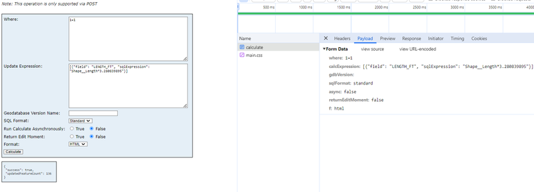
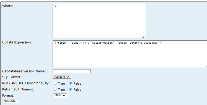
got it... hunting and hunting finally looking at the network payload in the browser i saw the parameter was called calcExpression not expression or Update Expresstion in the image above... ... gotta love cryptic naming conventions ESRI puts out... parameter names are different for each method of updating... uggg
    url = urlCalculateFeatures
    whereclause='1=1'
    gis_payload = {
        'token': currenttoken,
        'f': 'json',
        'calcExpression':'[{"field": "LENGTH_FT", "sqlExpression": "Shape__Length*300.280839895"}]',
        'sqlFormat':'standard',
        'where': f'''{whereclause}'''
        }
    print(gis_payload)
    response = requests.request("POST", url=urlCalculateFeatures, data=gis_payload)
- Mark as New
- Bookmark
- Subscribe
- Mute
- Subscribe to RSS Feed
- Permalink
Never mind I got it with this
def MetersToFeet(length):
    return (3.280839895) * length

def updateLengthField():
    for layer in layers_to_Update.keys():
        fromSDE = layer
        updateLayer = layers_to_Update[layer]
        fieldUpdate = "LENGTH_FT"
        arcpy.env.workspace = "Database Connections\\GIS_3_DEV@gis_data.sde"

arcpy.management.CalculateField("GIS_DATA.SDE_VDOT_MAINT_DITCHING", "LENGTH_FT", "MetersToFeet((float(!SHAPE.LEN!)))", "PYTHON3", "", "TEXT", "NO_ENFORCE_DOMAINS")- Mark as New
- Bookmark
- Subscribe
- Mute
- Subscribe to RSS Feed
- Permalink
The above now works BUT I want to get this working against a REST service ...
So something like the below but not DELETE rather CACULATE
Any thoughts?
    url = urlDeleteFeatures
    whereclause='1=1'
    gis_payload = {
        'token': currenttoken,
        'f': 'json',
        'where': f'''{whereclause}'''
        }
    response = requests.request("POST", url=url, data=gis_payload)
    print("Done Deleting")
I am not sure how the expression would look
- Mark as New
- Bookmark
- Subscribe
- Mute
- Subscribe to RSS Feed
- Permalink
Got with this:
BUT not sure how to get that into a python script..
Tried this... no error but nothing happening..
    url = urlCalculateFeatures
    whereclause='1=1'
    gis_payload = {
        'token': currenttoken,
        'f': 'json',
        'url':'https://xxxx.xxx.xx.gov/env/rest/services/DEV/UpdateLengthField/FeatureServer/0',
        'expression':'[{"field": "LENGTH_FT", "sqlExpression": "Shape__Length*30.280839895"}]',
        'where': f'''{whereclause}'''
        }
response = requests.request("POST", url=url, data=gis_payload)- Mark as New
- Bookmark
- Subscribe
- Mute
- Subscribe to RSS Feed
- Permalink
got it... hunting and hunting finally looking at the network payload in the browser i saw the parameter was called calcExpression not expression or Update Expresstion in the image above... ... gotta love cryptic naming conventions ESRI puts out... parameter names are different for each method of updating... uggg
    url = urlCalculateFeatures
    whereclause='1=1'
    gis_payload = {
        'token': currenttoken,
        'f': 'json',
        'calcExpression':'[{"field": "LENGTH_FT", "sqlExpression": "Shape__Length*300.280839895"}]',
        'sqlFormat':'standard',
        'where': f'''{whereclause}'''
        }
    print(gis_payload)
    response = requests.request("POST", url=urlCalculateFeatures, data=gis_payload)


