- Home
- :
- All Communities
- :
- Industries
- :
- Transportation
- :
- Public Transit
- :
- Public Transit Questions
- :
- Re: How to snap multimodal stops/points precisely/...
- Subscribe to RSS Feed
- Mark Topic as New
- Mark Topic as Read
- Float this Topic for Current User
- Bookmark
- Subscribe
- Mute
- Printer Friendly Page
How to snap multimodal stops/points precisely/exactly!!! to transportation lines?
- Mark as New
- Bookmark
- Subscribe
- Mute
- Subscribe to RSS Feed
- Permalink
Hi,
I have a problem that I can not solve. I have pretty much experience with ArcGIS, especially with transportation analysis.
I have one layer of multimodal stops, where is possible to change transportation mode, i.e. between bus and metro. In network dataset such stops represent connection points between bus and metro. Therefore such stops must be assigned to both connectivity groups - bus and metro.
One important condition is that these points must be located exactly on the line of transportation network. I tried to do it by geoprocessing tool Snap. It looked good, but when I zoomed in, I found out that the points do not lie exactly on the line. I tried many other tricks, but no success.
Then I used tool Locate Features Along Route. The result was a table, which I used to perform a Display Route Events. The result was a point layer Route Events. Only in this layer all points (multimodal stops) were located exactly on the transport lines, even when I zoomed in to maximum. But..... I can not use the point-layer Point Events as an input layer for network dataset. I must change it to shapefile or feature class. But then - points move a little bit away from transport lines.
I am in a kind of trap and I can not go on with my work.
Thank you very much for your help!
Klemen
Solved! Go to Solution.
Accepted Solutions
- Mark as New
- Bookmark
- Subscribe
- Mute
- Subscribe to RSS Feed
- Permalink
I've seen that problem with Snap before if the points and the lines don't have the same spatial reference. If they have different datums, then the snapping doesn't work exactly right. Use the Project tool (making sure to use a geographic transformation) to project your points and your lines into the same spatial reference. Then try Snap again.
- Mark as New
- Bookmark
- Subscribe
- Mute
- Subscribe to RSS Feed
- Permalink
Thank you very much for your answer! And I apologize for my late answer.
You are right. My transformation from WGS 84 to Clarke 1866 was not correct.
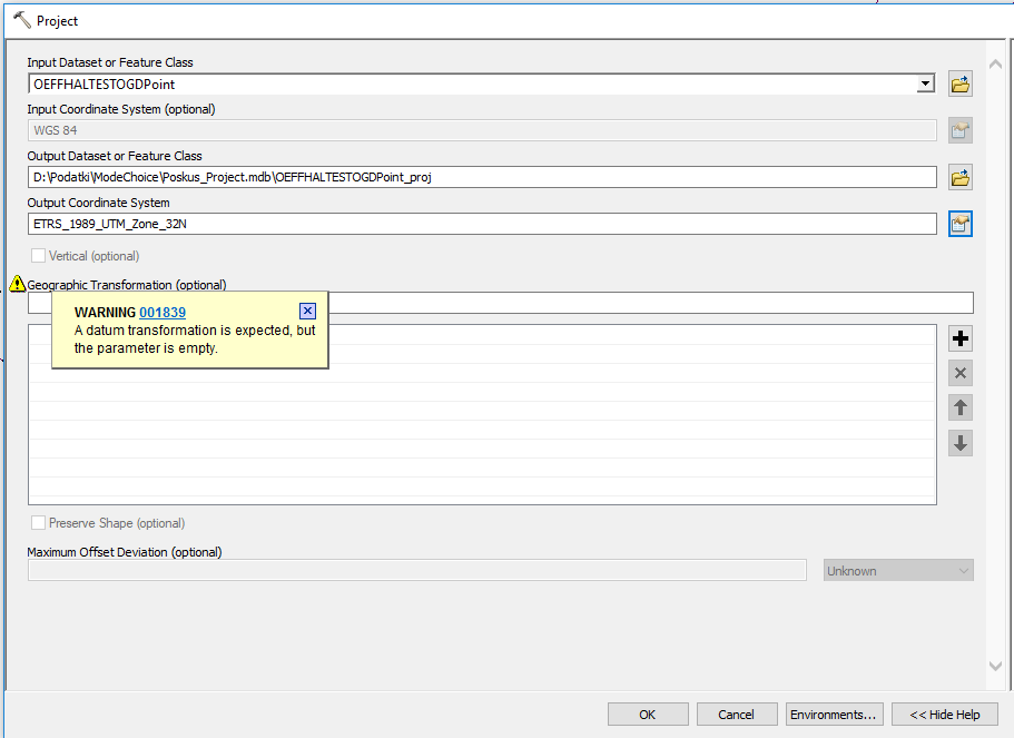
But here I have another problem. I can not perform transformation from WGS 84 to any other coordinate system (I must do the transformation because WGS 84 is not appropriate for network analysis). Certainly, I use tool Project. After I define a Geographic Transformation, I get the information: invalid geographic transformation? Could be something wrong with my original layers in WGS 84? But they are official from Austrian government.
- Mark as New
- Bookmark
- Subscribe
- Mute
- Subscribe to RSS Feed
- Permalink
Could you please share a screenshot with the inputs to Project tool? Which version of ArcGIS you are on? ArcGIS Desktop (ArcMap) or ArcGIS Pro?
- Mark as New
- Bookmark
- Subscribe
- Mute
- Subscribe to RSS Feed
- Permalink
Hello and thank you very much for your answer! I enclose a screenshot. I've tried different projected coordinate systems, but the answer is always the same. And the dropdown list for Geographic Transformation never appears. If I type certain geographic transformation, the answer is "invalid geographic transformation". I work with ArcMap. Would it be better to use ArcGIS Pro?
- Mark as New
- Bookmark
- Subscribe
- Mute
- Subscribe to RSS Feed
- Permalink
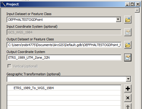
With your data I can see a valid transformation showing up. However, I'm on 10.7 - which version of Desktop you are on?
- Mark as New
- Bookmark
- Subscribe
- Mute
- Subscribe to RSS Feed
- Permalink
I am on ArcGIS Desktop 10.6.1
- Mark as New
- Bookmark
- Subscribe
- Mute
- Subscribe to RSS Feed
- Permalink
That looks like a slightly non-standard definition of GCS_WGS_1984.
That why Arc cannot find the appropriate transformation.
You should redefine it using the properties in Catalog.
- Mark as New
- Bookmark
- Subscribe
- Mute
- Subscribe to RSS Feed
- Permalink
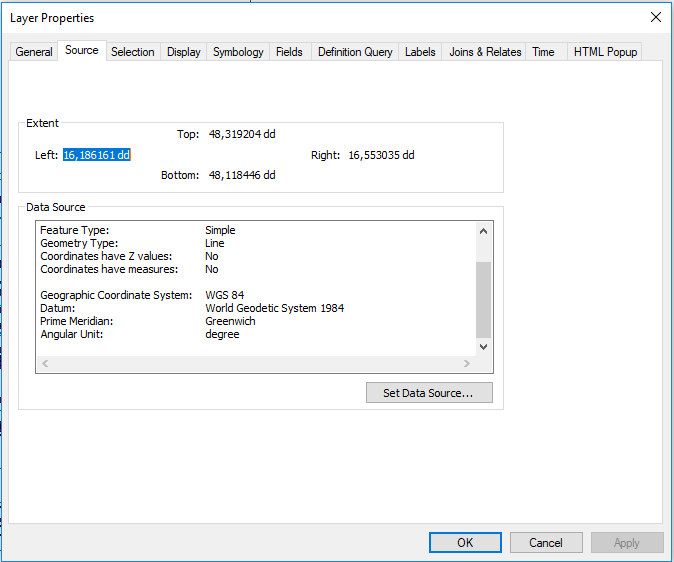
Hi Klemen Prah, could you please let us know the geographic extent of your input data?
- Mark as New
- Bookmark
- Subscribe
- Mute
- Subscribe to RSS Feed
- Permalink
Hi Nobbir Ahmed! The geographic extent is the whole city of Vienna (capitol city of Austria). Here are two links to both shapefiles: public transport lines and public transport stations.
Thank you very much!