- Home
- :
- All Communities
- :
- User Groups
- :
- New to GIS
- :
- Questions
- :
- Spatial reference does not match data frame
- Subscribe to RSS Feed
- Mark Topic as New
- Mark Topic as Read
- Float this Topic for Current User
- Bookmark
- Subscribe
- Mute
- Printer Friendly Page
Spatial reference does not match data frame
- Mark as New
- Bookmark
- Subscribe
- Mute
- Subscribe to RSS Feed
- Permalink
Hi everyone,
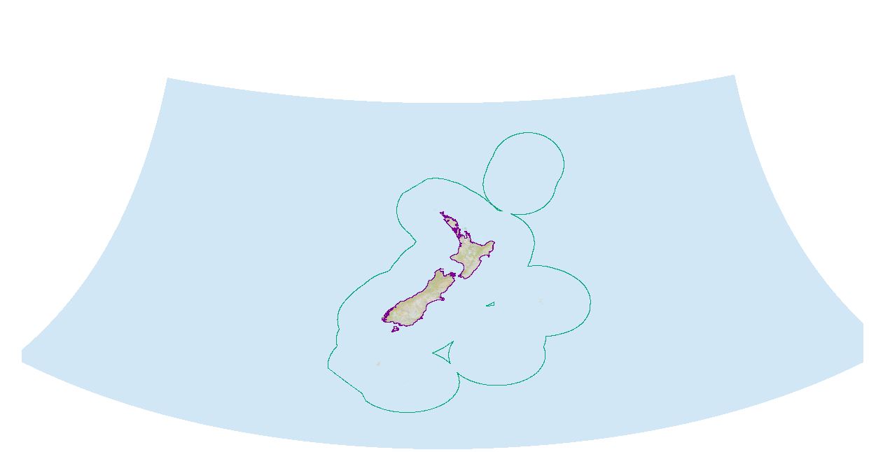
I'm new to the world of GIS, and a little confused as to why I'm getting the error ' Spatial reference does not match data frame'. The data frame and the layer(s) that I want to edit are in the same coordinate system (GCS_WGS84), but this error still pops up. So I tried to play around and start a new map where I am using just two layers (that according to their properties have the same coordinate system) and a base map from ArcGIS online. I noticed that the way the base map is displayed is different depending on which layer I pull in first from ArcCatalog, (even though they have the same coordinate system.) Could this be the reason? (and more importantly, will it have an effect on editing these layers?) Also why and how do you get the base map to display differently for the same coordinate system? (As I would prefer to have the base map with the ocean surrounding the landmass, not the base map where half the ocean is displayed on the other side of the screen.) I have attached images to show what I mean.
Any help with this would be much appreciated!
- Mark as New
- Bookmark
- Subscribe
- Mute
- Subscribe to RSS Feed
- Permalink
ArcMap will always project the data frame using the first layer you bring into the Table of Contents. Looking at your screenshot, it seems like your dataframe isn't actually projected, but is rather being drawn in the WGS84 Geographic Coordinate System (GCS WGS 84).
You have at least one layer that is projected using the NZGD_2000 Transverse Mercator projection, and a couple layers that are not projected (your economic zone and coastlines topo 150k).
Here's what I would do - I would start by projecting all of my source data to the same projected coordinate system. Then I would insert a new data frame into my ArcMap document. Bring all the layers you're interested in analyzing, and then finally add your basemap. ArcMap will project the basemap on-the-fly and you shouldn't see any warnings.
Please let me know if this is helpful information.
Edit - it would be worthwhile to familiarize yourself with the differences between geographic coordinate systems and projected coordinate systems. Namely why it is that you can't reliably measure distances using a GCS (hint - distances between degrees aren't uniform across the globe  ).
).
- Mark as New
- Bookmark
- Subscribe
- Mute
- Subscribe to RSS Feed
- Permalink
For the layers where the existing projection/coordinate system is already defined and one wants to change them to a different projection/coordinate system, one way to do this is by using the Project geoprocessing tool, which can be found in the Data Management toolbox.
Project—Data Management toolbox | ArcGIS Desktop
If instead the projection/coordinate system is unknown or incorrectly assigned and one is sure what it should be instead, one can use the Define Projection geoprocessing tool to update it.
Define Projection—Data Management toolbox | ArcGIS Desktop
Chris Donohue, GISP
- Mark as New
- Bookmark
- Subscribe
- Mute
- Subscribe to RSS Feed
- Permalink
Thanks for adding this Chris Donohue, GISP. Since we're posting in New to GIS this is especially useful information...
- Mark as New
- Bookmark
- Subscribe
- Mute
- Subscribe to RSS Feed
- Permalink
Thanks so much, Josh and Chris for taking the time to answer my question. I'm in the process of projecting all my source data to New Zealand Continental Shelf Lambert Conformal 2000 (the recommended projected coordinate system for the NZ continental shelf), and so hopefully once I get that done it will be full steam ahead with my analysis. Thanks again
- Mark as New
- Bookmark
- Subscribe
- Mute
- Subscribe to RSS Feed
- Permalink
You bet. If you run into any further issues please don't hesitate to ask