- Home
- :
- All Communities
- :
- Developers
- :
- Native Maps SDKs
- :
- .NET Maps SDK Questions
- :
- Re: MMPK - Scale-Based Sizing
- Subscribe to RSS Feed
- Mark Topic as New
- Mark Topic as Read
- Float this Topic for Current User
- Bookmark
- Subscribe
- Mute
- Printer Friendly Page
- Mark as New
- Bookmark
- Subscribe
- Mute
- Subscribe to RSS Feed
- Permalink
Is scale-based sizing supported in the Runtime SDK with MMPKs generated from ArcGIS Pro 2.1.2 (or will it ever be)? It doesn't seem to be carrying over whatsoever from Pro to Runtime. Opening the MMPK in Pro displays everything exactly as it does editing within the original project.
Solved! Go to Solution.
Accepted Solutions
- Mark as New
- Bookmark
- Subscribe
- Mute
- Subscribe to RSS Feed
- Permalink
Good news - the latest release of ArcGIS Runtime supports reference scales! https://www.esri.com/arcgis-blog/products/developers/announcements/welcome-to-arcgis-runtime-100-5/
https://developers.arcgis.com/net/latest/wpf/sample-code/mapreferencescale.htm
- Mark as New
- Bookmark
- Subscribe
- Mute
- Subscribe to RSS Feed
- Permalink
Hopefully to give you a better idea of the issue...
What the map looks like in ArcGIS Pro:

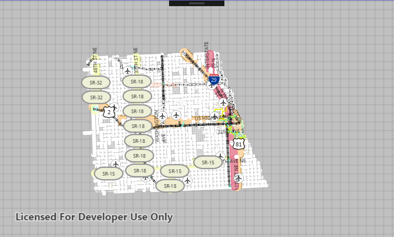
What the map looks like when loading the MMPK into a simple WPF app:

Many things don't seem to be sizing correctly, some labels are completely missing (or I now notice barely showing up) for unknown reasons (the city names highlighted in orange). The thick white lines throughout the county appear to be the roads that shouldn't be showing up with the scale sizing.
Any help or clarification on these differences would be greatly appreciated!
- Mark as New
- Bookmark
- Subscribe
- Mute
- Subscribe to RSS Feed
- Permalink
Any ideas/clarification on this? Even a simple yes/no on scale based sizing support would be helpful, and let me know I'm not doing something wrong.
Furthermore, this project consists of imported shapefiles that have styled/labeled. I'm taking GIS data (roads, addresses, ESN, hydrants, etc) from municipal GIS departments in this format because they are not prepared to migrate from ArcMap to ArcGIS Pro. The application we're developing has to follow an offline-first model, so taking this shapefile data and creating MMPKs from them seems to be the best way to handle this (I'm aware that the Runtime SDK directly supports reading shapefiles, but we're trying to move away from this model, and it still seems to be a bit buggy in the 100.x series compared to reading MMPKs). Am I totally off-base here, is this an unrealistic method of going about this?
- Mark as New
- Bookmark
- Subscribe
- Mute
- Subscribe to RSS Feed
- Permalink
I don't know the answer to the question, but we have had the behavior you expect with vector tile packages.
-Joe
- Mark as New
- Bookmark
- Subscribe
- Mute
- Subscribe to RSS Feed
- Permalink
Joe,
Thank you very much for the information. After wrestling with it for a few hours getting 9999 error codes trying to generate a vector tile package, I was finally able to accomplish this. Are you actually loading the vtpk file locally, and if so, would you mind pointing me in the right direction on how to do so? Every attempt using ArcGISVectorTiledLayer has resulted in a blank map, and I get a "File Not Found" error when actually calling LoadAsync on the layer which I believe actually means that it's not a supported file type (this is a known, misleading exception).
EDIT: Joe, I'm an idiot, and you're a genius. Forgot that you use forward slashes with URIs pointing to file paths. Map looks perfect as a Vector Tile Package, thank you so much!!
- Mark as New
- Bookmark
- Subscribe
- Mute
- Subscribe to RSS Feed
- Permalink
Kyle,
Scaling symbols when a reference scale is set for the map is not honored / supported by the ArcGIS runtime for Mobile Map Packages.
Internally it has been discussed, but no action so far, or currently no defined plan to support.
Mark
- Mark as New
- Bookmark
- Subscribe
- Mute
- Subscribe to RSS Feed
- Permalink
Thank you for the clarification! I do think this would be a very crucial feature to support for MMPKs, it sort of kills the styling and readability of the map without it. I do however think I have found a pattern of splitting files based on feature type and setting min/max visibilities that will end up accomplishing what I am looking for. Sometimes you just have to ask stupid questions to spark a good idea.
- Mark as New
- Bookmark
- Subscribe
- Mute
- Subscribe to RSS Feed
- Permalink
Kyle,
It will be supported, I just can't give any confirmation for when it will be available in release.
Since responding I have learned that support for it is being worked on.
Mark
- Mark as New
- Bookmark
- Subscribe
- Mute
- Subscribe to RSS Feed
- Permalink
Adding in support for a reference scale would be a great enhancement, and I'm excited that Esri is working on it. Do you have an update on when this will be available?
- Mark as New
- Bookmark
- Subscribe
- Mute
- Subscribe to RSS Feed
- Permalink
Good news - the latest release of ArcGIS Runtime supports reference scales! https://www.esri.com/arcgis-blog/products/developers/announcements/welcome-to-arcgis-runtime-100-5/
https://developers.arcgis.com/net/latest/wpf/sample-code/mapreferencescale.htm