- Home
- :
- All Communities
- :
- Developers
- :
- Native Maps SDKs
- :
- .NET Maps SDK Questions
- :
- Geodatabase v100.1
- Subscribe to RSS Feed
- Mark Topic as New
- Mark Topic as Read
- Float this Topic for Current User
- Bookmark
- Subscribe
- Mute
- Printer Friendly Page
Geodatabase v100.1
- Mark as New
- Bookmark
- Subscribe
- Mute
- Subscribe to RSS Feed
- Permalink
Hello, i am trying work with geodatabase in ArcGISRuntime v100.1 for .NET. I created from .tif files .gdb folder (with files), but when i want load data, it throw exception.
Geodatabase geodatabase = await Geodatabase.OpenAsync(@"C:\Users\myname\Desktop\MapTest.gdb");
-> Exception: ErrorCode = 20, Message = "No data".
What that mean? Is even possible load .gdb in v100.1? I found some examples with .geodatabase for v100.1, but when i want generate it in ArcMap (ArcGIS Runtime Content) it show few errors.
What is the best way for load a large number of .tif files to layers? I thought about create for each file one Raster and then RasterLayer, but how can i effective set data about each Raster? I have actualy .mdb file with this informations (minx, maxx, miny, maxy,..). Is possible generate .json file for my rasters from .gdb?
Thanks for every idea!
- Mark as New
- Bookmark
- Subscribe
- Mute
- Subscribe to RSS Feed
- Permalink
Hi Jana,
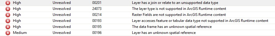
I have the same issue but with ".geodatabase" file. I have tried to load the same data and it worked from Runtime samples code, but did not work from my. I found that my application is UWP and sample application is WPF. I have generated new ArcGIS Runtime for WPF application, pasted my code and it worked.
I am new to ArcGIS Runtime too, but I haven't found that you can load ".gdb" databases to Runtime application. I have made my ".geodatabase" file from ArcMap. At startup I have got errors like you, but I checked and eliminated errors.
- Mark as New
- Bookmark
- Subscribe
- Mute
- Subscribe to RSS Feed
- Permalink
File Geodatabases aren't supported. You will have to export the data to an "ArcGIS Runtime Geodatabase" (using the ArcGIS Runtime Content tool) for it to work.