- Home
- :
- All Communities
- :
- Industries
- :
- Natural Resources
- :
- Natural Resources Questions
- :
- Re: Flow Distance tool generates areas of NoData
- Subscribe to RSS Feed
- Mark Topic as New
- Mark Topic as Read
- Float this Topic for Current User
- Bookmark
- Subscribe
- Mute
- Printer Friendly Page
- Mark as New
- Bookmark
- Subscribe
- Mute
- Subscribe to RSS Feed
- Permalink
Hi,
I am trying to calculate the Flow Distances for North-American catchments, but the result shows several areas of NoData (there is a picture attached, explanation below). Input is a void-filled DEM and a rivers polyline feature that I converted to a raster, both products are provided by HydroSHEDS and therefore should be linked and suitable for that operation.
The areas of NoData might be associated with a projection issue, since running the tool with the original geographic coordinate system (NAD 1983 (2011)/EPSG 6318) gives an output without gaps. But running the tool with a GCS, the resulting pixel values have unit in degrees!! Preferably the flow distances should be given in meters and for cellsizes of 100*100m.
I ran the tool on one catchment of 104467.82 km^2 to check for several combinations, such as projections and flow models (D8, MFD, DINF), cell sizes, additional input of a flow direction raster (gives even more NoData), which all did not work.
Is there a workaround to get the preferred meters out of the degrees? I am aware of the conversion from dergrees to meters since the calculation needs to be done for the North American continent.
Or, even better, is there a way to calculate the flow distance in a projected coordinate system?
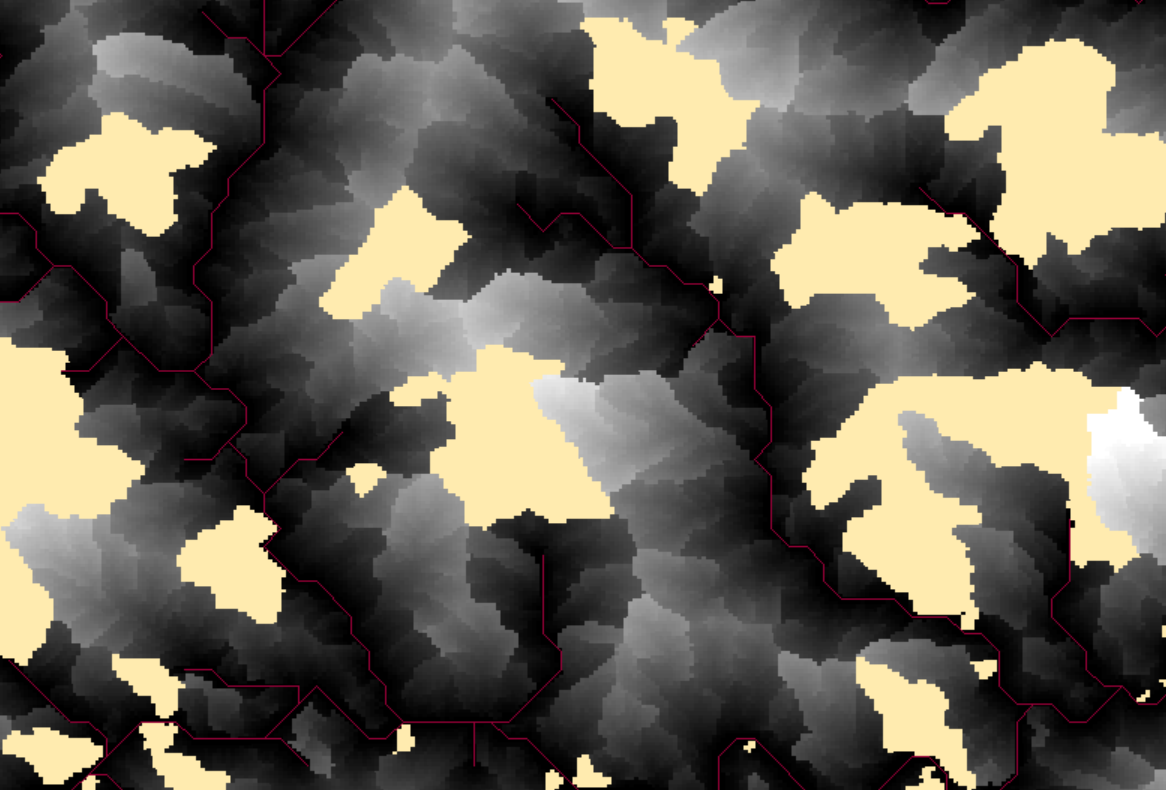
Please find attached a picture of a small extent, 1 pixel = 100m*100m, red lines= rivers, yellow=NoData, in gray the calculated flow distances are displayed
I am using ArcGIS 10.8
Thanks!
Solved! Go to Solution.
Accepted Solutions
- Mark as New
- Bookmark
- Subscribe
- Mute
- Subscribe to RSS Feed
- Permalink
The issue comes with the projection.
I solved it under utilization of the tool "Fill"
- Mark as New
- Bookmark
- Subscribe
- Mute
- Subscribe to RSS Feed
- Permalink
I think you need to clarify your projections. I'm suspecting you mean that NAD83 is the Datum of your original Planimetric Coordinate System (not geographic coordinate system). Which you've then converted to something like GCS WGS84?
I'm not aware of any Hydro tools having any Geodesic methods, and any analysis involving a raster with a GCS input would be invalid analysis for a variety of reasons, one of which being the horizontal and vertical scale relationship being off.
Depending on your area (size and location etc.) you may be able to use a UTM projection based on NAD83, or reproject to some area or scale preserving projection, Lambert Conformal Conic, Lambert Azimuthal Equidistant etc. but I'm straying out of my experience/knowledge there so only take that as a guide - hopefully someone with a finer grasp of Geodesy/North America CRSs can chip in.
- Mark as New
- Bookmark
- Subscribe
- Mute
- Subscribe to RSS Feed
- Permalink
Hi David, thanks for your reply!
Here is the overview for the involved Coordinate Systems:
original void-filled DEM: EPSG 6318
original flow direction raster: EPSG 6318 (since it's based on the DEM)
original rivers polyline feature: EPSG 4269
by converting all layers to EPSG 6318, a continuous result of flow distances is calculated
flow distance tool fails at EPSG 4269, EPSG 6343 (which is UTM Zone 14, suitable for the extracted catchment), WKID 102008 (North America Albers Equal Area Conic), and now I have also checked the WKID 102009 (North America Lambert Conformal Conic)
As an additional information: for the rivers polyline feature, the projection was done before converting the polyline to raster
Using an UTM projection for the whole area of North America is not possible
I could not find usable information to explain the Planimetric Coordinate System. Since the used DEM shows cellsizes of 0.00083333333, the unit should be degrees and therefore belong to a Geographic CS.
If the flow distance analysis with a GCS is invalid and the conversion therefore, too, it is even more important to me to find a suitable workaround..!
- Mark as New
- Bookmark
- Subscribe
- Mute
- Subscribe to RSS Feed
- Permalink
It should run if every raster is initially reprojected to 102008 or 102009 (I think these all preserve the original 1983 datum). Ensure the geoprocessing environments aren't overriding anything during processing.
- Mark as New
- Bookmark
- Subscribe
- Mute
- Subscribe to RSS Feed
- Permalink
Unfortunately this is what I did, giving me the flow distance results containing areas of NoData.
Geoprocessing environments should be fine I think, the output CS is the same as input CS
- Mark as New
- Bookmark
- Subscribe
- Mute
- Subscribe to RSS Feed
- Permalink
The issue comes with the projection.
I solved it under utilization of the tool "Fill"
- Mark as New
- Bookmark
- Subscribe
- Mute
- Subscribe to RSS Feed
- Permalink
Hi,
Could you please explain how you solved the problem? Did you use Fill tool to the flow distance layer?