Turn on suggestions
Auto-suggest helps you quickly narrow down your search results by suggesting possible matches as you type.
Cancel
- Home
- :
- All Communities
- :
- Products
- :
- ModelBuilder
- :
- ModelBuilder Questions
- :
- Basic functions and Route Measure Editing in Model...
Options
- Subscribe to RSS Feed
- Mark Topic as New
- Mark Topic as Read
- Float this Topic for Current User
- Bookmark
- Subscribe
- Mute
- Printer Friendly Page
Basic functions and Route Measure Editing in ModelBuilder
Subscribe
4629
4
10-30-2012 11:53 AM
10-30-2012
11:53 AM
- Mark as New
- Bookmark
- Subscribe
- Mute
- Subscribe to RSS Feed
- Permalink
I will grovel around, maybe even go to Google Searching, maybe even call ESRI, but here goes:
1) I want to add basic a File function into Model Builder, as in: File-Add Data-Add Route Events. Is there a way to create a function like this in Model Builder? I have tried Insert-Create Variable in ModelBuilder but there's nothing that says Route Event. What do I do?
2) I have a polyline file in ModelBuilder (add data). How do I create something in Model Builder that allows me to add a Projected Coordinate System (State Plane California Zone II FIPS 03 or something like that) and Modify the projection from Foot_US to Mile_US. Is this even possible? Or do I need to bring the file I created like this into the Model Builder before I start creating a Toolbox? (As in Add Data in Model Builder)?
3) How do I add in Vertice/Route Measure Editing functions into ModelBuilder ? As in: Customize--ToolBars--Route Measure Editing. Again, I go to Create Variable in Model Builder but there's nothing on this.
The reason I ask all of this is that I will be ultimately working with Counties' roads layers which will have a very large number of road segments that will need Linear Referencing and will ultimately be submitted to an FHWA application. I would like to automate the procedures above and integrate them with the other Linear Referencing functions.
Dan B
4 Replies
11-01-2012
09:31 AM
- Mark as New
- Bookmark
- Subscribe
- Mute
- Subscribe to RSS Feed
- Permalink
Luke,
I do appreciate your attempts at helping me, but I'm afraid you misread my questions entirely.
I will say that one of the functions I would like to bring in to my model is selecting a Projection and Modifying its measurement units. How would I go about that in the Model Builder process?
I have attached jpgs of screen shots of the functions I'm talking about. These are quite basic questions.
Off Sys 1-4 are screen shots of the functions and stages of them that I am trying to add to the Model itself in Off Sys 5. The Model is in the process of being built so bear with me on that end.
Go back to what I am referring to. I just want to add functions that come with ArcCatalog, the File menu, and layers--such as Route Measure Editing of Vertices.
I might guess that I won't be able to bring these in, but at the same time it couldn't hurt to ask.
Dan B
11-03-2012
09:44 PM
- Mark as New
- Bookmark
- Subscribe
- Mute
- Subscribe to RSS Feed
- Permalink
Luke,
I do appreciate your attempts at helping me, but I'm afraid you misread my questions entirely.
I will say that one of the functions I would like to bring in to my model is selecting a Projection and Modifying its measurement units. How would I go about that in the Model Builder process?
I have attached jpgs of screen shots of the functions I'm talking about. These are quite basic questions.
Off Sys 1-4 are screen shots of the functions and stages of them that I am trying to add to the Model itself in Off Sys 5. The Model is in the process of being built so bear with me on that end.
Go back to what I am referring to. I just want to add functions that come with ArcCatalog, the File menu, and layers--such as Route Measure Editing of Vertices.
I might guess that I won't be able to bring these in, but at the same time it couldn't hurt to ask.
Dan B
You can do the things shown in the first three screen shots in ModelBuilder, because these are geoprocessing tools. Look at the Data Management Toolbox and the Lineaer Referencing Toolbox. You cannot do the Route Measure Editiing in ModelBuilder directly. This is a manual editing method available only in an ArcMap session and has no geoprocessing equivelent out of the box. You could write a python script to manipulate the individual vertices (such as sum the lengths of each vertice segment in a polyline made up of straight line segments), but there is no variable or tool in ModelBuilder to do this directly. Look in the Python forums for ideas on how to write such a script. I have written vertice editing routines in VBA and .Net as an ArcMap Editor extension, but those cannot be used in ModelBuilder. I don't have a ready made Python sample for you.
11-05-2012
06:53 AM
- Mark as New
- Bookmark
- Subscribe
- Mute
- Subscribe to RSS Feed
- Permalink
Can you explain which route editing functions you would want to perform in your model? Perhaps, using the right geoprocessing tools, you won't need to use them at all?
11-19-2012
01:59 PM
- Mark as New
- Bookmark
- Subscribe
- Mute
- Subscribe to RSS Feed
- Permalink
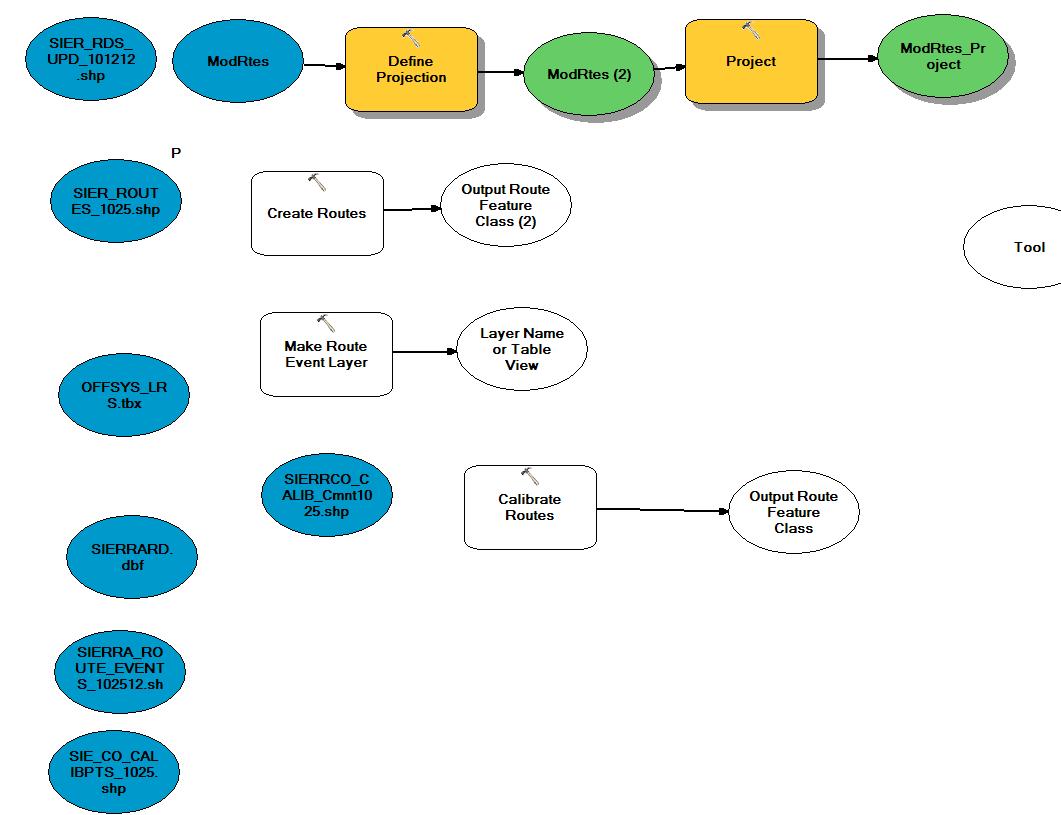
I talked with another ESRI Support person and he told me the same stuff you did about vertex editing and ModelBuilder. I was able to create a ModelBuilder for the first 3 actions, but part of me wonders what's the use if they're that simple to do, even for a large county and its roads (i.e. LA County). That's another discussion.
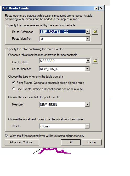
What I'm curious about now is that I am going File--Add Data--Add Route Events, using a calibrated roads layer which I believe has perfectly good geometry, adding an event table, using the correct Begin and End fields, and I end up with a layer that is missing vertices and whole roads as well! Even a section where I edited the vertices during Route Measure Editing didn't mess up! I did at one point take a look at the Route Table I had and fixed up things here and there and the coverage got better, but things that I didn't think would screw up, did!
Here are some screen shots of what I'm talking about.
I will admit at one point I went back to the Events table I have and edited some names of the routes and that helped some, and on another try I got roads to show up that aren't right now. Something is really bizarre here, because I never had this problem before?!
Daniel Brenner