Turn on suggestions
Auto-suggest helps you quickly narrow down your search results by suggesting possible matches as you type.
Cancel
- Home
- :
- All Communities
- :
- Products
- :
- Mapping
- :
- Mapping Questions
- :
- Re: Representation VS Layer File
Options
- Subscribe to RSS Feed
- Mark Topic as New
- Mark Topic as Read
- Float this Topic for Current User
- Bookmark
- Subscribe
- Mute
- Printer Friendly Page
by
Anonymous User
Not applicable
08-27-2012
12:59 PM
- Mark as New
- Bookmark
- Subscribe
- Mute
- Subscribe to RSS Feed
- Permalink
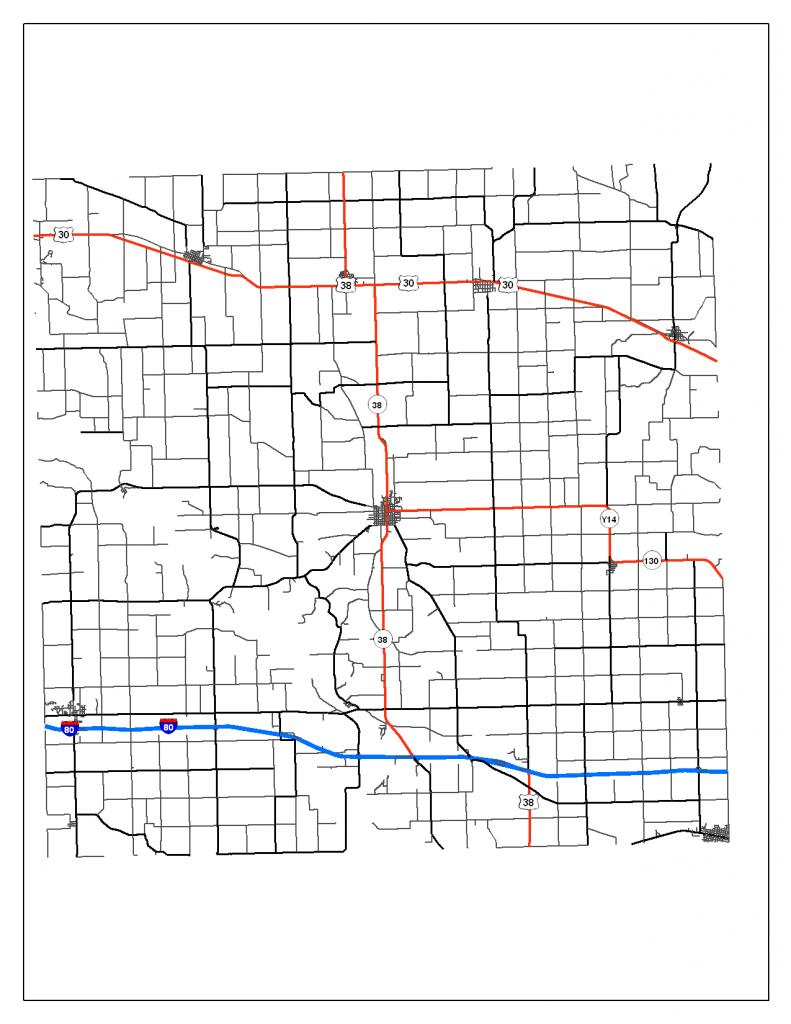
I was playing around with the symbology and labels for our County Roads and wanted to save the display settings as a representation and some weird things started to happen. The first screenshot is the Roads FC before converting to representation.
[ATTACH=CONFIG]17271[/ATTACH]
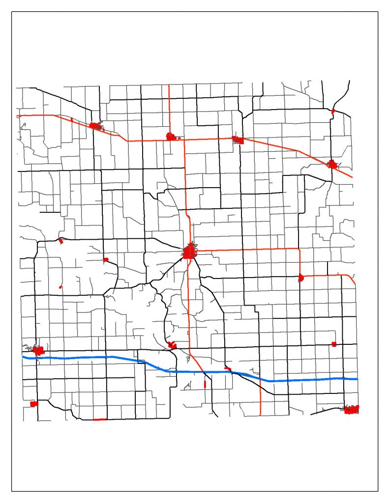
So Far so good, it gets converted to representation fine. However, when I pull in the Roads FC with the updated representation it looks like this:
[ATTACH=CONFIG]17272[/ATTACH]
I do not know why some of the city roads are showing up as red like the state highways. Some of the roads are state and city highways but the way I have the symbology set up, they are symbolized and labeled by the appropriate fields for the appropriate scales. Also, I saved the Roads FC as a layer file and the layer file looks exactly like the first screenshot with no problems. Does anyone know why the representation does not work the same way?
Caleb
[ATTACH=CONFIG]17271[/ATTACH]
So Far so good, it gets converted to representation fine. However, when I pull in the Roads FC with the updated representation it looks like this:
[ATTACH=CONFIG]17272[/ATTACH]
I do not know why some of the city roads are showing up as red like the state highways. Some of the roads are state and city highways but the way I have the symbology set up, they are symbolized and labeled by the appropriate fields for the appropriate scales. Also, I saved the Roads FC as a layer file and the layer file looks exactly like the first screenshot with no problems. Does anyone know why the representation does not work the same way?
Caleb
Solved! Go to Solution.
1 Solution
Accepted Solutions
08-27-2012
05:38 PM
- Mark as New
- Bookmark
- Subscribe
- Mute
- Subscribe to RSS Feed
- Permalink
I was playing around with the symbology and labels for our County Roads and wanted to save the display settings as a representation and some weird things started to happen. The first screenshot is the Roads FC before converting to representation.
[ATTACH=CONFIG]17271[/ATTACH]
So Far so good, it gets converted to representation fine. However, when I pull in the Roads FC with the updated representation it looks like this:
[ATTACH=CONFIG]17272[/ATTACH]
I do not know why some of the city roads are showing up as red like the state highways. Some of the roads are state and city highways but the way I have the symbology set up, they are symbolized and labeled by the appropriate fields for the appropriate scales. Also, I saved the Roads FC as a layer file and the layer file looks exactly like the first screenshot with no problems. Does anyone know why the representation does not work the same way?
Caleb
Hi Caleb.
I suggest you check if your city roads have their correct Rule ID Field in the attribute table, because you can have those red lines because of one of two reasons:
a. The feature's RuleID doesn't have a RuleID assigned and it displays as a NoRule Representation.
b. The feature's RuleID it's the same as your highways and it's representation is the same.
Remember that using representations use the RuleID as the field that assign the symbol.
Good Luck
2 Replies
08-27-2012
05:38 PM
- Mark as New
- Bookmark
- Subscribe
- Mute
- Subscribe to RSS Feed
- Permalink
I was playing around with the symbology and labels for our County Roads and wanted to save the display settings as a representation and some weird things started to happen. The first screenshot is the Roads FC before converting to representation.
[ATTACH=CONFIG]17271[/ATTACH]
So Far so good, it gets converted to representation fine. However, when I pull in the Roads FC with the updated representation it looks like this:
[ATTACH=CONFIG]17272[/ATTACH]
I do not know why some of the city roads are showing up as red like the state highways. Some of the roads are state and city highways but the way I have the symbology set up, they are symbolized and labeled by the appropriate fields for the appropriate scales. Also, I saved the Roads FC as a layer file and the layer file looks exactly like the first screenshot with no problems. Does anyone know why the representation does not work the same way?
Caleb
Hi Caleb.
I suggest you check if your city roads have their correct Rule ID Field in the attribute table, because you can have those red lines because of one of two reasons:
a. The feature's RuleID doesn't have a RuleID assigned and it displays as a NoRule Representation.
b. The feature's RuleID it's the same as your highways and it's representation is the same.
Remember that using representations use the RuleID as the field that assign the symbol.
Good Luck
by
Anonymous User
Not applicable
08-28-2012
05:21 AM
- Mark as New
- Bookmark
- Subscribe
- Mute
- Subscribe to RSS Feed
- Permalink
Original User: Caleb1987
Leonardo,
Thanks for the reply. Your suggestions helped me find the problem. It turns out that everything was fine in the representation file and I had just forgotten that I had all the allies not symbolized in the original file due to a definition query. I guess I should have checked that first!
Caleb
Leonardo,
a. The feature's RuleID doesn't have a RuleID assigned and it displays as a NoRule Representation.
Thanks for the reply. Your suggestions helped me find the problem. It turns out that everything was fine in the representation file and I had just forgotten that I had all the allies not symbolized in the original file due to a definition query. I guess I should have checked that first!
Caleb