- Home
- :
- All Communities
- :
- Products
- :
- Mapping
- :
- Mapping Questions
- :
- Layer does not match imagery by 400 meters..
- Subscribe to RSS Feed
- Mark Topic as New
- Mark Topic as Read
- Float this Topic for Current User
- Bookmark
- Subscribe
- Mute
- Printer Friendly Page
- Mark as New
- Bookmark
- Subscribe
- Mute
- Subscribe to RSS Feed
- Permalink
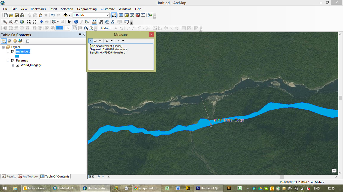
Hello all,
I have been looking for answers, from coordinate systems issues to projection issues but have not found a solution to this sticky one yet. As you can see below, my river SHP does not match the river on the satellite imagery... only by... 400 meters. Coordinate systems and projections are the same (I projected the river shapefile (was WGS84UTMzone47N) to the projection of the imagery. Would anyone have a clue what the problem is?
Thanks!
GGN406
Solved! Go to Solution.
Accepted Solutions
- Mark as New
- Bookmark
- Subscribe
- Mute
- Subscribe to RSS Feed
- Permalink
This sort of shift is caused by an incorrect datum (change in the underlying ellipsoidal model).
I took your mainrivers shapefile, I see it is of the Mekong river in Cambodia.
Yes, it's coordinate system is defined as UTM 47N and based on the WGS84 datum. However, if you assume that WGS84 is not the original datum for this data (depends on the source of these river polys, old carto sheets perhaps).
I looked up at ASPRS Clifford Mugnier Grids & Datums page and also at EPSG.org. There are several suggestions as to the original classical datums used by the French authorities in colonial days. One of which is India1960. (Don't know why they would have used this).
So, I copied the shapefile, gave it a new name, and then redefined the coord sys, changing the GCS to India 1960.
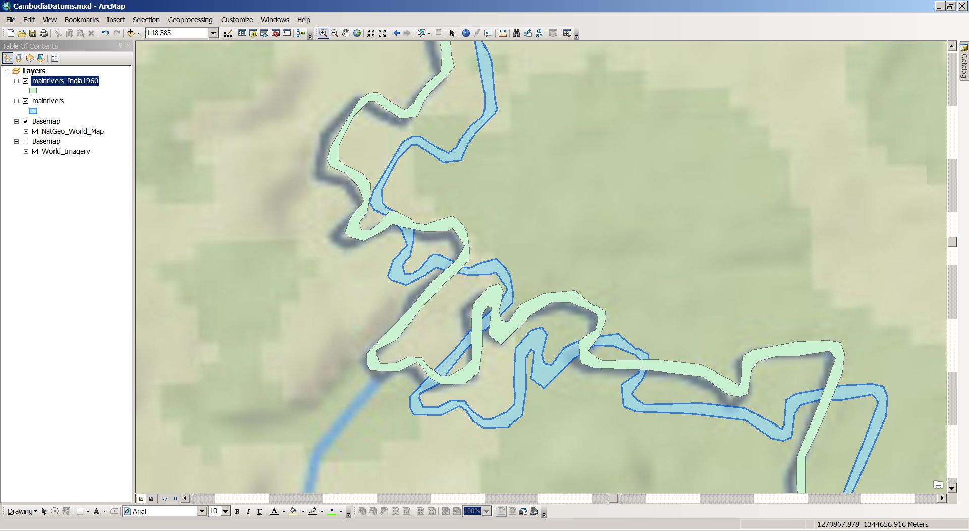
So the blue is the original, the green te new one, and I have applied one of the available transforms between India1960 & WGS84.
The base map in National Geographic (good enough in this case).
You can see that the green one is much closer to the basemap image. The difference here between old and new is ~500m.
The fit is not exact (I wouldn't expect it to be), because we do not know on which datum this data was originally based.
The only thing we do know for sure is that it definitely wasn't WGS84.
- Mark as New
- Bookmark
- Subscribe
- Mute
- Subscribe to RSS Feed
- Permalink
The basemaps projection is 'WGS_1984_Web_Mercator_Auxiliary_Sphere'. Could you please try reprojecting our shp in this projection? Then open a new ArcMap session, add basemap first and add shapefile and observe the behavior. If possible, attach your shp file.
Hope this is helpful
Kishor
- Mark as New
- Bookmark
- Subscribe
- Mute
- Subscribe to RSS Feed
- Permalink
Can you put on another layer that you know is the same projection as the imagery to see if the imagery is accurate?
For example cadastre (lot boundaries) is generally quite accurate, and I will use them as a reference file sometimes to check the accuracy of aerial imagery and data captured by consultants. Does the river/imagery align to a known accurate feature class?
Similarly check the accuracy of the river in its original projection (again use a feautre you know to be accurate).
- Mark as New
- Bookmark
- Subscribe
- Mute
- Subscribe to RSS Feed
- Permalink
I have done the same with another SHP i.e. add SHP first then added basemap. Much better results ie only 40 meters mismatch (see below, blue SHP is still 400 meters off but new (red) SHP is much closer to the river). So it looks like my first SHP is not of very good quality...
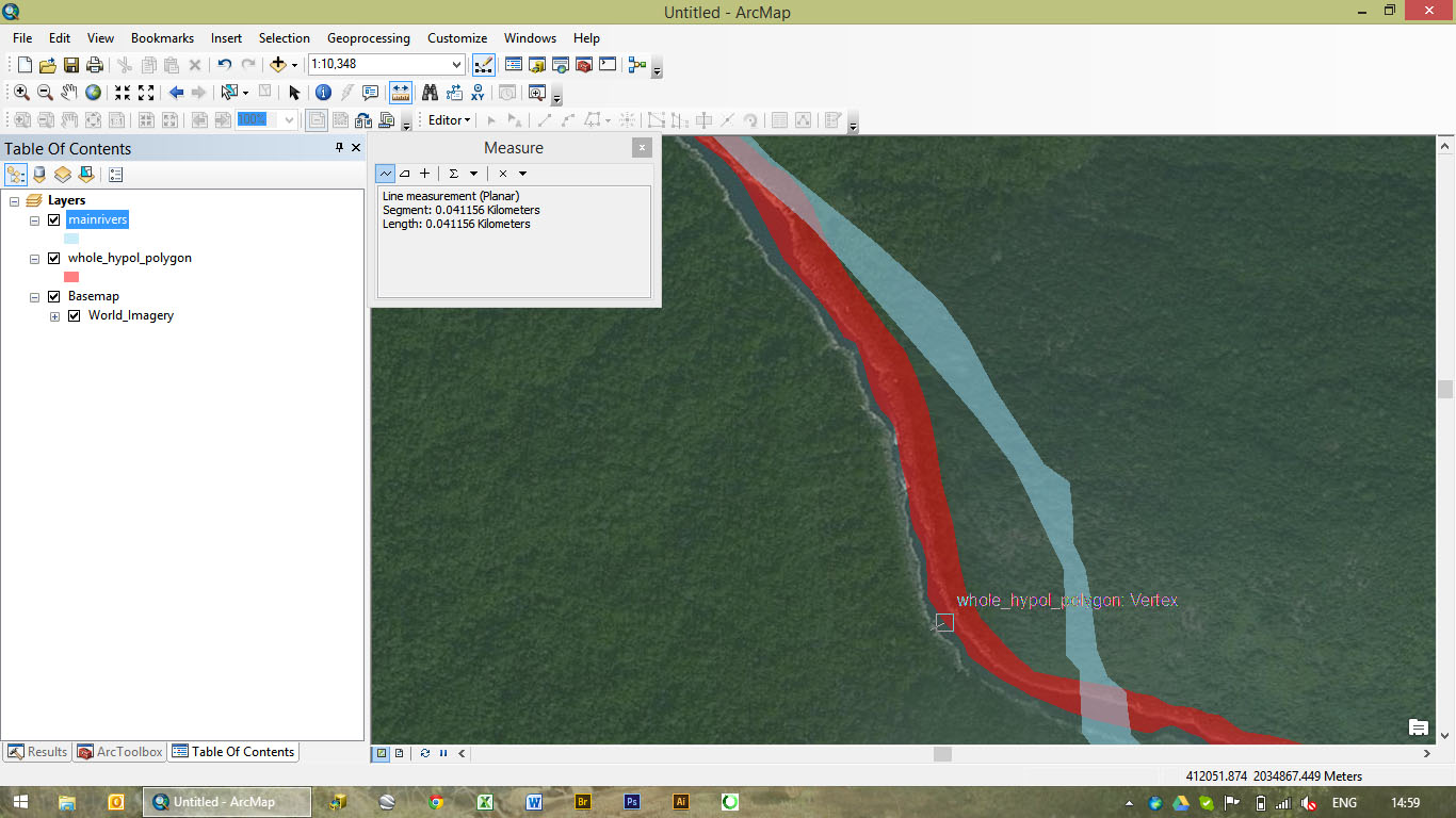
Now the question is what can I do to move my original SHP 400 meters? This is I guess where my GIS skills are too limited but I would like to learn!
- Mark as New
- Bookmark
- Subscribe
- Mute
- Subscribe to RSS Feed
- Permalink
just editing and moving the SHP manually worked alright actually!
- Mark as New
- Bookmark
- Subscribe
- Mute
- Subscribe to RSS Feed
- Permalink
That's a lot of work if you have to do it on bigger or other datasets.
It would be a better way forward to do some research on the origins of the data. And tell whoever captured the data not to just "rename" the datum.
- Mark as New
- Bookmark
- Subscribe
- Mute
- Subscribe to RSS Feed
- Permalink
This sort of shift is caused by an incorrect datum (change in the underlying ellipsoidal model).
I took your mainrivers shapefile, I see it is of the Mekong river in Cambodia.
Yes, it's coordinate system is defined as UTM 47N and based on the WGS84 datum. However, if you assume that WGS84 is not the original datum for this data (depends on the source of these river polys, old carto sheets perhaps).
I looked up at ASPRS Clifford Mugnier Grids & Datums page and also at EPSG.org. There are several suggestions as to the original classical datums used by the French authorities in colonial days. One of which is India1960. (Don't know why they would have used this).
So, I copied the shapefile, gave it a new name, and then redefined the coord sys, changing the GCS to India 1960.
So the blue is the original, the green te new one, and I have applied one of the available transforms between India1960 & WGS84.
The base map in National Geographic (good enough in this case).
You can see that the green one is much closer to the basemap image. The difference here between old and new is ~500m.
The fit is not exact (I wouldn't expect it to be), because we do not know on which datum this data was originally based.
The only thing we do know for sure is that it definitely wasn't WGS84.
- Mark as New
- Bookmark
- Subscribe
- Mute
- Subscribe to RSS Feed
- Permalink
Thanks a lot Neil! This is really useful and I believe this is the correct answer. Indeed moving SHP around in editing mode is neither scientific nor time efficient. I will look more into this datum issue as I have a lot of SHP in my library that display similar issues. Interesting how colonial history is helping understand current GIS issues!
- Mark as New
- Bookmark
- Subscribe
- Mute
- Subscribe to RSS Feed
- Permalink
Hi Neil,
I have been trying to do this following your guidelines but to no avail. Should I do this directly in Catalog or should it be through the toolbox i.e. either Project or Define Projection? If there are guidelines online that you know and could refer to that would be great.
Thanks again!
Francois