- Home
- :
- All Communities
- :
- Products
- :
- Mapping
- :
- Mapping Questions
- :
- Label direction for Streets / lines?
- Subscribe to RSS Feed
- Mark Topic as New
- Mark Topic as Read
- Float this Topic for Current User
- Bookmark
- Subscribe
- Mute
- Printer Friendly Page
- Mark as New
- Bookmark
- Subscribe
- Mute
- Subscribe to RSS Feed
- Permalink
I am creating a street map and the client would like all of the north-south streets to have labels that read in the same direction (i.e. all labels starting at the southern end of the street).
I have done a lot of searching and the only information I have found is that I can control the direction of text for a polyline label by orienting it to the line direction. This doesn't help me. Does anyone know of a way to make this happen without having to convert to annotation and then rotating all offending labels?
In a related matter, is there a way to limit how far a label can be moved from a feature when using key numbering for labels?
Solved! Go to Solution.
Accepted Solutions
- Mark as New
- Bookmark
- Subscribe
- Mute
- Subscribe to RSS Feed
- Permalink
The answer is ultimately that this is not something that can be controlled through either labeling engine and there will always be offending labels to any labeling strategy you want using automated labeling. You have to get as close to what you want and then convert to annotation if your client demands labeling to show the ends of roads and start at a specific road end.
The Regular Placement Option gives you the ability to play with the most combinations of parameters. That option does expose a Label Offset option to control which line end the label starts at, but this option requires every line to be oriented exactly to fit your labeling strategy (i.,e. all north/south lines must start at the south and end at the north or vice versa). You should combine that with a reduction of units allowed for the Overrun Feature option. Even if every line in your network is perfectly oriented to fit your ideal labeling strategy the results will have odd placements in numerous areas of your map.
- Mark as New
- Bookmark
- Subscribe
- Mute
- Subscribe to RSS Feed
- Permalink
Ariana,
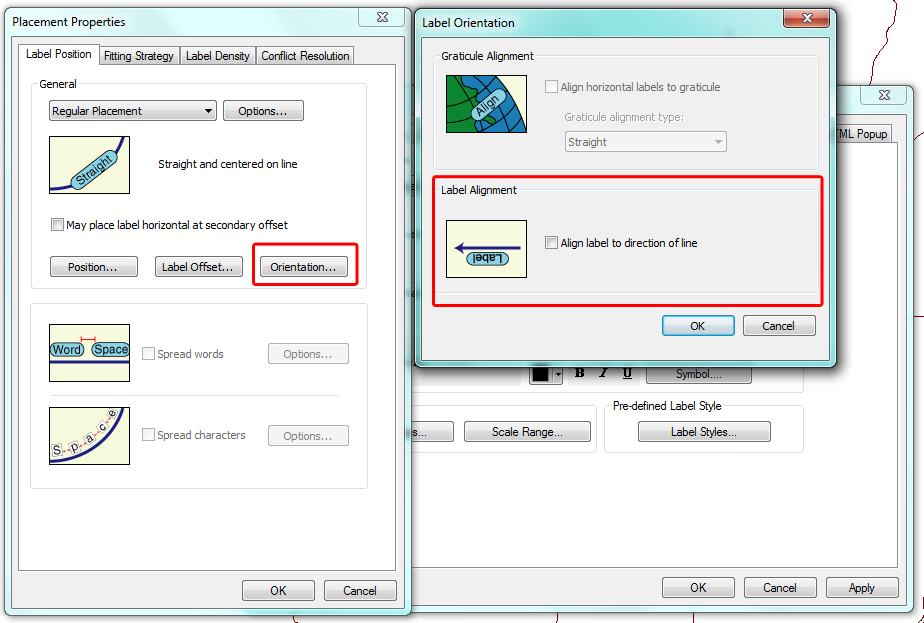
You should have access to the Maplex label engine. Using the Maplex label engine you have much more control over label placement and orientation. You can choose the label placement tab and in the General box click the Orientation... button and then you will find the Label Alignment option for Align label with direction of line.

P.S. I am also moving this post to the mapping space and that is a more appropriate space for this question.
- Mark as New
- Bookmark
- Subscribe
- Mute
- Subscribe to RSS Feed
- Permalink
The answer is ultimately that this is not something that can be controlled through either labeling engine and there will always be offending labels to any labeling strategy you want using automated labeling. You have to get as close to what you want and then convert to annotation if your client demands labeling to show the ends of roads and start at a specific road end.
The Regular Placement Option gives you the ability to play with the most combinations of parameters. That option does expose a Label Offset option to control which line end the label starts at, but this option requires every line to be oriented exactly to fit your labeling strategy (i.,e. all north/south lines must start at the south and end at the north or vice versa). You should combine that with a reduction of units allowed for the Overrun Feature option. Even if every line in your network is perfectly oriented to fit your ideal labeling strategy the results will have odd placements in numerous areas of your map.
- Mark as New
- Bookmark
- Subscribe
- Mute
- Subscribe to RSS Feed
- Permalink
Thanks Richard. I had a feeling that it wasn't going to be possible but for as long as ESRI has been in the game I felt like it should be possible.
- Mark as New
- Bookmark
- Subscribe
- Mute
- Subscribe to RSS Feed
- Permalink
Yes labeling street segments "properly" requires a large amount of time invested. However, once accomplished the final product will only have to be "maintained" when new streets are added or existing streets are re-aligned. The labeling engine I used only provided about 60% of the labels in the correct position and orientation. The remainder had to be "manually" adjusted!