- Home
- :
- All Communities
- :
- Products
- :
- Mapping
- :
- Mapping Questions
- :
- Re: how to make grid index for data driven pages t...
- Subscribe to RSS Feed
- Mark Topic as New
- Mark Topic as Read
- Float this Topic for Current User
- Bookmark
- Subscribe
- Mute
- Printer Friendly Page
how to make grid index for data driven pages the correct extent and location
- Mark as New
- Bookmark
- Subscribe
- Mute
- Subscribe to RSS Feed
- Permalink
I am using the cartography grid index features tool for ArcGIS 10.3.1.
It does not appear to have all of the options and boxes that i see in the tutorials and instructions online
Here is the map i am hoping to make into data driven pages with a grid of square polygons
I have tried all sorts of different combinations in the boxes. I either get one big square polygon over my map, or i get a giant grid of square polygons above my map (my map is the small blob in the lower left of the photo below).
Any advice on what i am doing wrong?
thanks
- Mark as New
- Bookmark
- Subscribe
- Mute
- Subscribe to RSS Feed
- Permalink
I suspect your coordinate systems are at play, perhaps you have geographic data in a projected coordinate system but entering planar coordinates which are being interpreted as degrees. Rectify or confirm that your data are in a useful projected coordinate system, then you can enter planar units
- Mark as New
- Bookmark
- Subscribe
- Mute
- Subscribe to RSS Feed
- Permalink
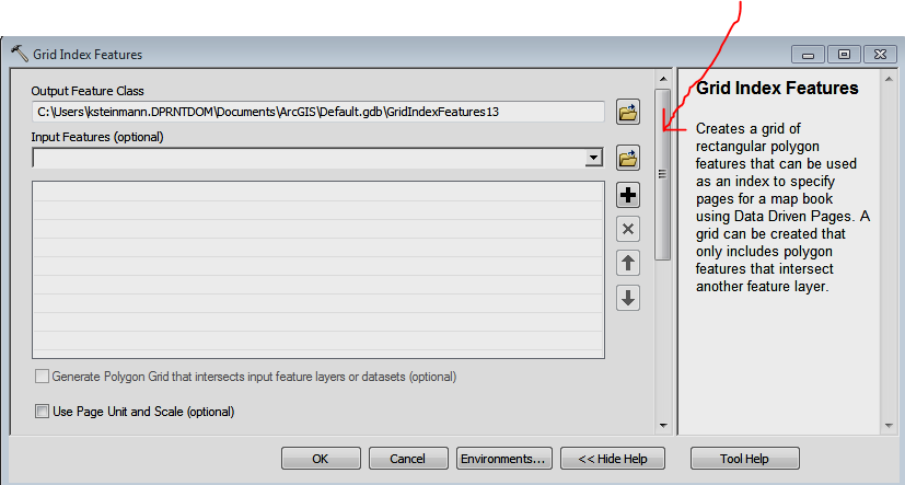
Hmmm... scroll down? ![]()

- Mark as New
- Bookmark
- Subscribe
- Mute
- Subscribe to RSS Feed
- Permalink
I think Dan is on the likely issue.
Also, a question - is the line layer (streets?) being used as the Input Features (optional) when running the tool? Doing so will cause grids to just be created where the lines are. If things are still going awry, can you post a screenshot of your tool settings input just before running the tool.
Chris Donohue, GISP
- Mark as New
- Bookmark
- Subscribe
- Mute
- Subscribe to RSS Feed
- Permalink
About the shift between the grid and your extend polygon is think it is coordinate system error like DAN said. may be your feature class has not defined coordinate system.
after you project your feature class make sure that you checked on Generate polygon Grid that intersect input feature datasets , to get the grid that you asked.

- Mark as New
- Bookmark
- Subscribe
- Mute
- Subscribe to RSS Feed
- Permalink
thank you all so much - i now have the grid i was looking for!
- Mark as New
- Bookmark
- Subscribe
- Mute
- Subscribe to RSS Feed
- Permalink
Kimberly, make sure to mark all those that were helpful, and the one that answered you question as correct. Or if you resolved it yourself, it would be helpful to others if you gave a summary.